Previous Forecast
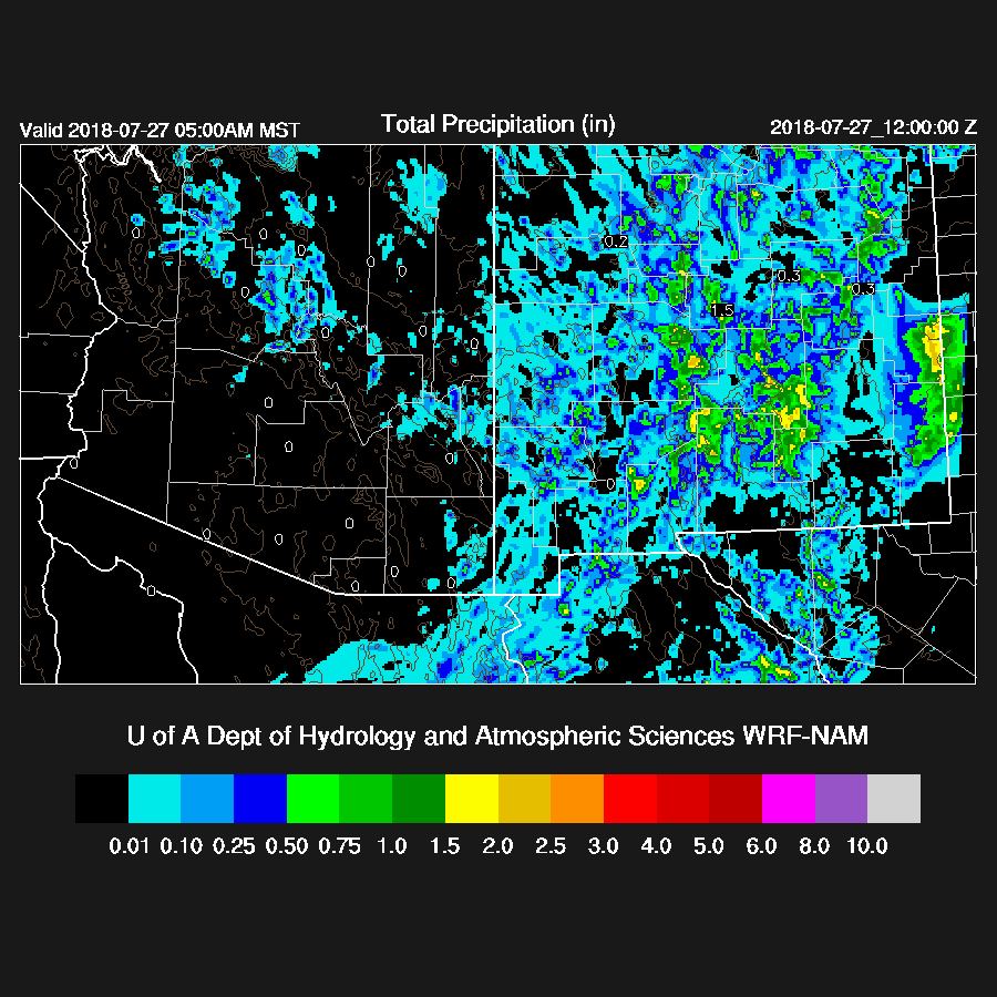
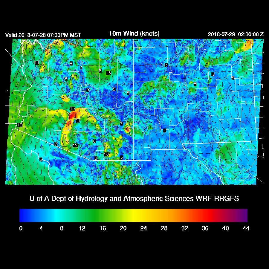
Areas of scattered strong storms were over the high country and SE Arizona while NM had large areas of heavy precipitation. All the 12Z runs were pretty good but the WRFNAM was the best. It didn’t have quite enough precipitation in Cochise county though.

Initializations
The 500mb high center continues over far western Arizona which puts much of the state in generally light northerly flow and -6 to -7C temperatures. A large MCS continues to move across southern Sonora this morning and looking at the initializations, the IT is just part of a much larger cyclonic circulation associated with the MCS. Both the NAM and RR have this feature.
Scattered to broken mid and high level clouds are over southern Arizona and it’s mostly clear elsewhere. Mid-level clouds are moving rapidly to the SSW as the circulation around the MCS is quite strong with 20-30 knots across far SE Arizona and into Sonora. Cloud initializations are good.
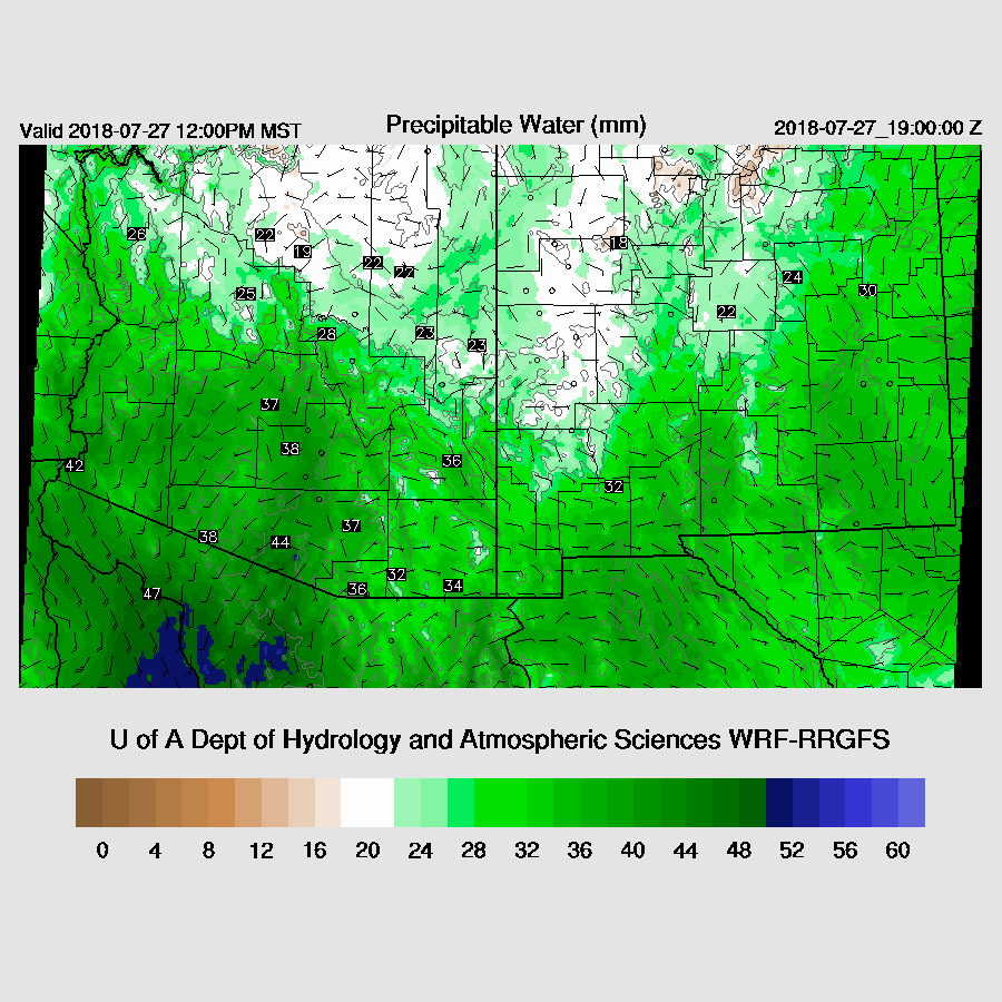
Again, the NAM has some major PW errors in southern NM and into Sonora near the MCS, as high as 20mm too wet at Hermosillo. On the other hand, the RR has minimal errors except for about 5mm too wet at Hermosillo. Looking at the first few hours of the forecast, the WRFNAM is doing okay vs observed values so it’s probably okay for today. The WRFRR initialized well.
Day 1
Moist and cool air continues to stream into the state due to a strong gulf surge while low level easterly flow is present over far SW NM into SE Arizona. This boundary, which looks to be around the Cochise/Pima County and up into Gila, may be the focal point for storms today.
Good mid-level steering continues over southern along with some cooler air advecting southward which will help steepen lapse rates. The big question is how much cooling there is in the lower atmosphere.

A lack of CAPE is not going to be a problem as it’s moderate to high over much of the state.

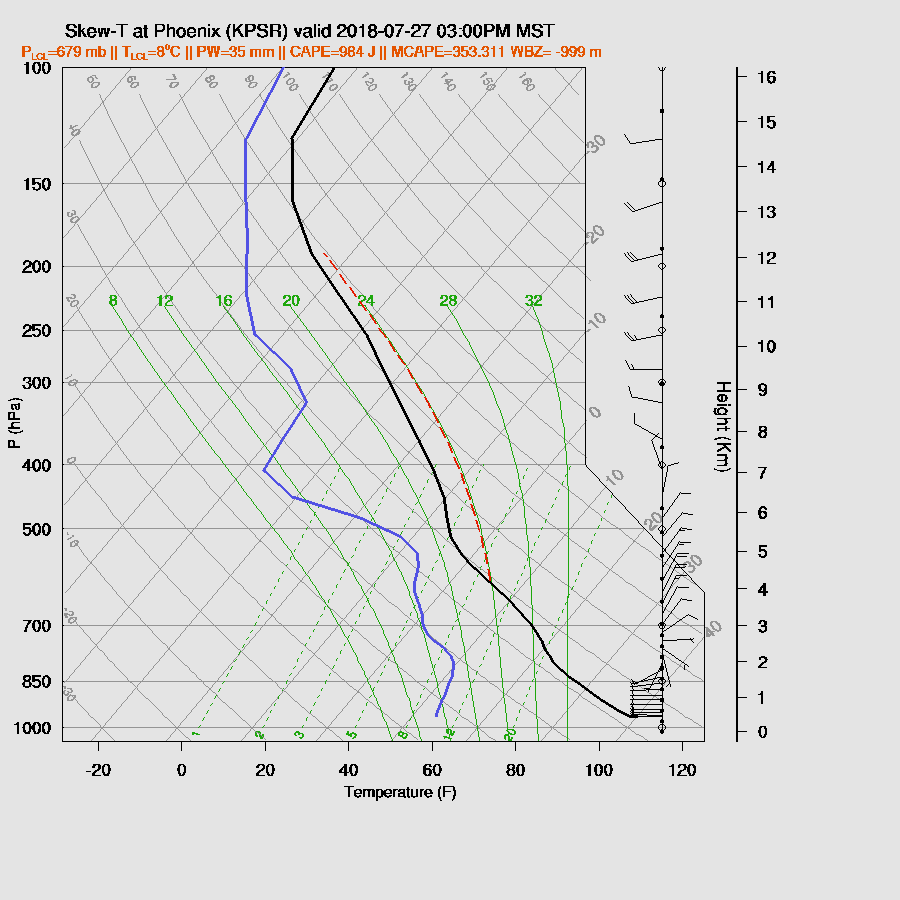
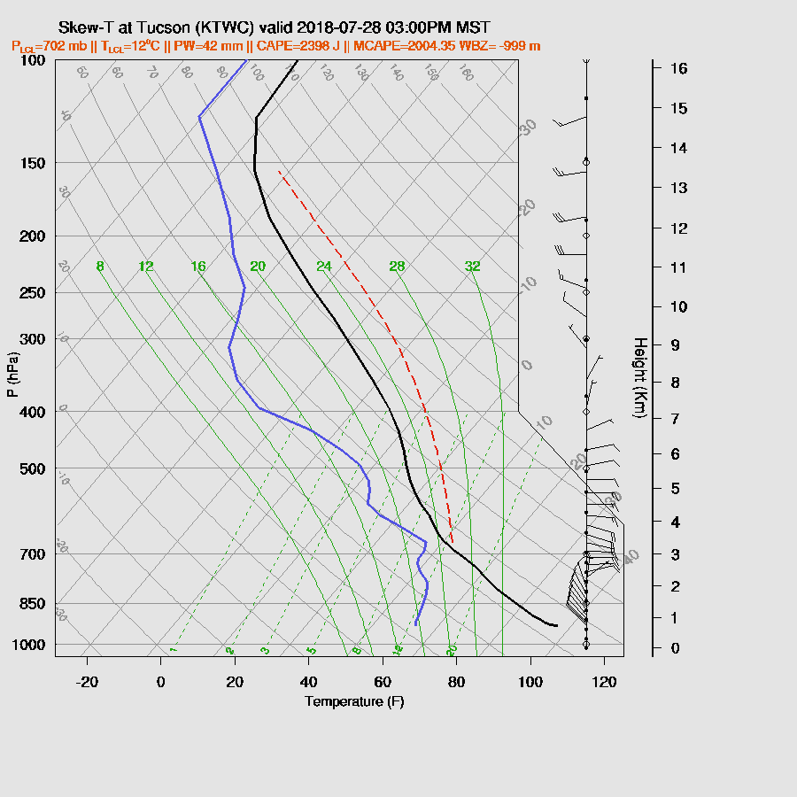
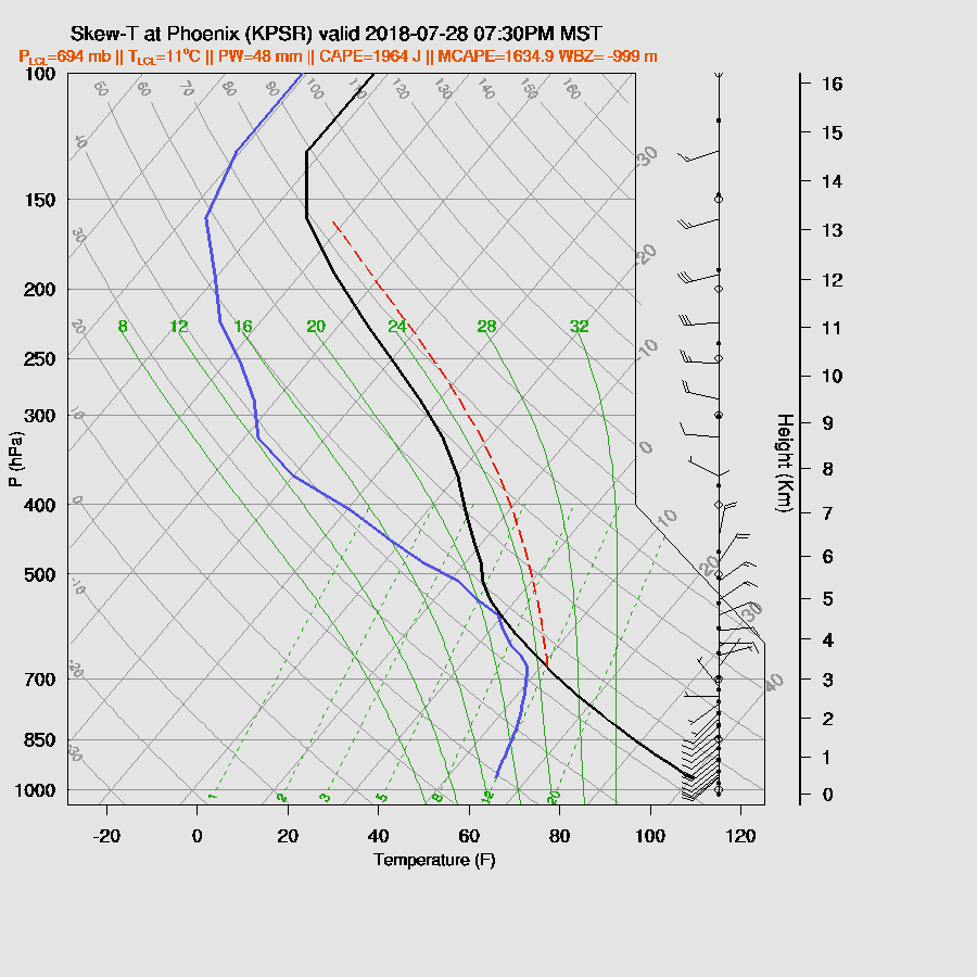
At least for Tucson, the PBL cooling doesn’t look to be too bad as the PBL is mixed fairly well with only a weak inversion present. The wind profile is excellent.

Phoenix has a stronger inversion at the top of the PBL with quite warm air above thus it’s going to be difficult for deep convection there.
Once again, some strong storms are scattered about over the Rim and the White Mountains. SE Arizona is mainly devoid of deep convection this afternoon.

Storms once again get close to Phoenix but die off before they get there. It looks like the best case is just a moderate outflow during the early evening.

By early evening, storms decrease over much of the high country but a few pop up over far SE Arizona. There is less activity forecast for this area compared to what was forecast yesterday. My guess is the cooler air from the Mexican MCS has prevented much of southern Arizona from heating up enough for widespread storms.

It’s possible for a storm or two in and around Tucson this evening as the PBL is mixed fairly deeply by this time and there is around 900 J/kg of CAPE.

The WRFNAM redevelops activity late this evening over SE Arizona which may or may not happen as it’s the only run that has this forecast.

Day 2
Moist air continues to stream into western and central Arizona as a weak surge continues.

CAPE is impressive over much of the state except for the far SE where a little drier air moved in from NM.

The 500mb anticyclone center is over NW Arizona which places much of the state in easterly or northeasterly flow and favorable for storm propagation. We sure have had some good flow the last week or two but it hasn’t resulted in much activity for the lower deserts.

Wow, the afternoon model vertical profile certainly looks good for Tucson. Enormous CAPE and an excellent wind profile.
Day 2 forecast accuracy have been pretty bad lately (today is a prime example) because the day 1 situations have been so active in Mexico, so I’m not too confident in the forecast. The WRFRR develops strong storms over the high country very strong/severe storms along the border. As upper winds are from the southwest, anvil shading could be an issue for the Tucson area.

The anvils don’t seem to be a problem for the WRFRR! Strong to severe storms develop over eastern Pima and into Pinal Counties during the late afternoon.

Strong storms move into western Pinal during the evening. The WRFNAM has about the same timing but storm intensity and coverage are much less.

A strong outflow boundary moves into Maricopa county likely accompanied by a large haboob.
This outflow boundary may be able to provide enough mesoscale lifting for deep convection in the Phoenix area. Phoenix has quite a bit of CAPE so any storms that form are likely to be strong and produce very strong winds as the sub cloud layer is quite deep.
The WRFRR develops only a few storms near Phoenix as it appears that the outflow boundary isn’t quite enough to really get things going. It’s too bad that no good outflows are generated to the north of Phoenix as it looks like outflow boundary intersections would be needed for widespread storms.

No comments:
Post a Comment
Note: Only a member of this blog may post a comment.