Wednesday, August 24, 2022

20220824

 Previous Forecast

Severe storms rampaged across western Arizona again, while the Phoenix and Tucson area only saw a little activity.  The forecasts had a lot of uncertainty for the urban areas as some had limited activity, and some had a lot.  SE Arizona was much more active than it's been recently, and in my neck of the woods, Portal picked up over 3" of rain.  Most runs missed Cochise County activity, but not all!  If I continue making these forecasts next year, one of my goals is a better display of the suite of morning runs, similar to what the NWS does with their HREF.


Discussion

It is a complicated flow regime over the western NA at 12Z with a high amplitude ridge over BC and stretches nearly to the north pole.  Another cutoff low is trapped in the ridge over gton.  Arizona has quite cool temperatures over northern Arizona at -8C, but southern Arizona is warmer at -6C.  A weak trough is located near the NM Bootheel or south in Chihuahua and seems rible for the clouds there.


A weak surge is underway in southwestern Arizona as surface dewpoints are again in the mid-70s, and PW rebounded into the low 50s despite the strong activity in the area last night.  This is interesting as yesterday's model forecasts had drying and less CAPE in the wake of the activity.  Despite not having much activity, Phoenix looks worked over, with only 175 J/kg of MLCAPE.  Steering flow is good with 10 to 20 knot ENE flow, but there is no low-level shear.

I've been using ACARS data quite a bit this season to watch the evolution of the vertical profile at Phoenix.  Here's a 1210Z pprettye; you can see it's quite accurate.  However, the winds are always weaker than observed.  Maybe they are in m/s? 
Tucson doesn't look any better.  Zero CAPE and no low-level shear.  Westerlies have made it to almost 500mb.  

It's also dried out as PW is in the mid-30s.  It's not looking good for Tucson unless there is an increase in moisture/CAPE.

Initializations
Cloud initializations were mostly accurate except for the RR runs, as coverage was too much over western Arizona and a few showers/storms.  However, these errors shouldn't matter for central/eastern Arizona.  The weak IT south of the bootheel is mostly initialized OK, except for the GFS, which didn't have the circulation.  The WRFHRRR and RR have better initializations.  Generally, the WRFGFS has been too active this year, just like the regular GFS are for the medium term. 

Day 1
The weak surge continues into the afternoon but isn't strong enough to reverse the flow from easterly, which is in place over much of eastern and central Arizona.  PW remains at high to very high levels.

850mb dewpoints are back to extreme levels of 15-17C for much of central and western Arizona.  They are even high in the southeasterly flow in southeastern AZ and SW NM.  This is one of the few cases where SE flow doesn't result in drying.

It's the same old story with CAPE as much of the eastern 1/2 of the state is below 1000 J/kg, which is enough for medium and high elevations but not good for lower elevations.  CAPE continues to be good for southrelativelyrn Arizona.  CAPE is quite high for the Grand Canyon region, so maybe some good storms there?


The high terrain of the Rim to the White Mountains is quite active by mid-afternoon, while the rest of the state is quiet.

Heating results in some CAPE at Tucson, but there is a subsidence inversion at 500mb.  Steering is OK, but there is no low-level shear.  The PBL is mixed well, but with the lack of CAPE, any storms that form will be weak.

Much the same story in Phoenix.  The PBL is mixed deeply by late afternoon, but CAPE is insufficient to support big storms.

Some weak activity is expected in the Phoenix area as storms from the north and east move into the valley this evening.


It looks like another big night for far western Arizona.  Casino flooder in Vegas?


Day 2
Moisture decreases somewhat as 850mb dewpoints are from 14-16C.  They are still very high, though.

CAPE is also a little lower but still sufficient for high terrain storms.  Despite OK CAPE, western Arizona's string of storms is probably over.


Only scattered, mainly weak storms are expected tomorrow.


Tuesday, August 23, 2022

20220823

 Previous Forecast

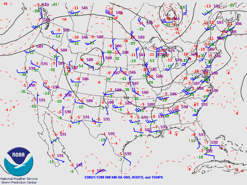
The below plots are from 21-22 Aug. Several strong/severe lines of storms moved north to south over much of western Arizona.  While the runs missed the heavies precipitation near Prescott, they mainly had the right idea.

Discussion

The 500mb pattern is optimal for steering high elevation storms from northern and eastern Arizona into the lower deserts.  Another positive is that 500mb temperatures have lowered to -6 to -7C, with cooler -9C air upstream in Ut and CO.  A weak trough is over eastern NM.


It is difficult to decipher what is going on at 300mb.  However, the WV imagery indicates a cyclonic circulation is off the coast of northern Baja, which may result in some upper divergence/difluence over southern Arizona.

PW continues to decrease, and it's below 40mm at Tucson, with the trend being down, but there is still more than enough.  MLCAPE isn't that great, as it's only 475 J/kg, but it should improve as the day goes on due to good heating.  An inversion at 800mb will need to be removed before deep convection can go.  The vertical wind profile is OK as there are about 10 knots of ENE flow and upper winds are pretty strong, at 40 knots from the southwest.


Phoenix looks better as MLCAPE is 1100 J/kg, the steering flow is northeasterly at 10 to 15, and the upper flow is in the opposite direction of the steering.  Like Tucson, there is a bit of an inversion at 750mb.

Initializations
Clouds, or the lack of them, were initialized well.  One issue is the location of the upper-level trough, as the initialization has quite a sharp trough over western Arizona and nothing obvious west of there.  WV imagery shows a weak trough over Puerto Penasco and another circulation west.  Other than that, everything looks well initialized, including CAPE.

Day 1
A weak, shallow surge continues for SW Arizona while the easterly downslope flow is underway for eastern Arizona.

This slight drying results in only low CAPE for much of southeastern Arizona.  The rest of the southern 1/2 of the state has moderate to high CAPE.

Some big storms get going over the higher terrain of the Rim and the higher terrain SW of Flagstaff, as well as in the high CAPE areas of central/western Pima County.

The forecast calls for a very impressive CAPE at Phoenix by late afternoon.  A moderately strong cap is at the top of the fairly shallow mixed layer, so it may take strong outflow or outflow interactions to get storms to pop.  There isn't any shear in the low levels, but mid and upper winds are favorable.
CAPE is "meh" at Tucson, and the steering flow is only about 5 to 10 knots.  Check out the 50 knots at 250mb!  Anvils from the activity over central and western Pima County will likely move over the valley later in the afternoon. suppose the 250mb forecast location of the trough is correct. In that case, it lifts out over SE Arizona later this afternoon, resulting in unfavorable convergence over southern Arizona but favorable divergence over northern Arizona.

There is no real consistency in what happens in either Tucson or Phoenix.  Some runs have activity, while others run storms around Tucson and Phoenix, as we've seen quite a few times this season.  As CAPE is so high in Phoenix, I'm inclined to go with the more active Phoenix runs.  Tucson, who knows?

15Z WRFHRRR is much less active for Tucson and Phoenix.


All runs agree on moving strong/severe storms into southwestern Arizona again.  They certainly have seen a lot of activity over the past week.

Day 2
A weak surge continues for southwestern Arizona, keeping PW relatively high there.  Easterly flow continues over much of southeastern Arizona, keeping activity limited there.

Combined with the easterly downslope flow and the considerable activity from the previous day, CAPE is mainly low over most of the eastern 1/3 of the state but probably sufficient for mountain storms.  It's still moderate for parts of western Arizona.  Like today, some runs have some storm activity for Tucson/Phoenix, and some do not.


Sunday, August 21, 2022

20220821

Previous Forecast

It was another active afternoon and evening.  Storms developed multiple times north of Phoenix and moved south into the lower elevations.  NM really got slammed near Roswell with over 11".


This is shocking to me that one of the runs, the 12Z WRFRR, could predict this extreme event( lower left).  Elsewhere, the forecasts were quite good as well.  


Discussion
It looks like central and western Arizona will have another high to low elevation event.  I've been keeping my eye on the cutoff low over UT as it reminded me of the multiple-night heavy rain and resulting flood event in Tucson in 2006.  A low parked itself around the Four Corners for a few days resulting in storms forming over NE Arizona during the afternoon hours and then making it all the way to southeastern Arizona overnight.  Something similar happened yesterday as storms developed over SW Utah and eventually moved across western Arizona early this morning.

2006.  Note the lack of sounding data from Mexico...this was the case for many years until SNM got their act together around 5 years ago.  It wasn't any fun trying to forecast with no data from upstream.

Tucson and Phoenix are quite worked over and have minimal MLCAPE.  But, that doesn't seem to matter much in central and western Arizona, as heating has been sufficient for recovery.  NE steering flow is excellent, and the upper level is now dominated by south-westerlies.   PW has decreased but is still very high.


Initializations
Again, thick clouds are in place over most of southeastern and southcentral Arizona, but clouds and showers are dissipating.  It looks like the tropical low is ejecting over the Bootheel of NM.  Clouds were initialized accurately by all runs, but the earlier initializations had the NM low too far to the SW. 


Day 1
The models say the low-level remnant circulation is still over the northern Gulf of California.  Nothing seems evident from the satellite imagery.  There is still a lot of deep convection near Hermosillo, though.  Afternoon 850mb flow continues to advect 15-16C dewpoints into much of the state.

CAPE is extremely high over the Colorado River but is probably strongly capped.  CAPE recovers from the Rim to the south and is high by afternoon.  CAPE has improved over southeastern Arizona, so a few storms are possible there as well.

Storms develop around Flagstaff by early afternoon and are threatening Phoenix by late afternoon.  All morning runs are very similar, so confidence is high.

I might as well call it now... "here we go."  This is one of Phoenix's best model forecast Skew-Ts of the year.  Low-level shear, mid-level steering, westerly upper-level.  CAPE is very high, from 2000-2300 J/kg.  Phoenix is strongly capped but should be broken with the monster storms moving in.

Many runs predict widespread strong to severe winds as the storms move into the Phoenix area.


Some earlier runs have storms clipping the west side of Phoenix, but later runs have storms in and around Phoenix. 


Earlier runs were much more active in and around Tucson, but the 12Z runs have backed off, which makes sense with only 800 CAPE.  Other features are positive: low-level shear, steering, upper winds, and a minimal inversion on top of the mixed layer.  It could happen.

There is a big difference between the 12Z WRFRR and WRFHRRR as the WRFRR keeps the line of storms going into SW Arizona and has quite a bit of activity around Tucson.  Maybe 15Z runs will shed some light on the situation.

Day 2
The atmosphere is highly modified in central and western Arizona, but much of southeastern Arizona has a bit more CAPE.