Friday, October 7, 2016

20161007

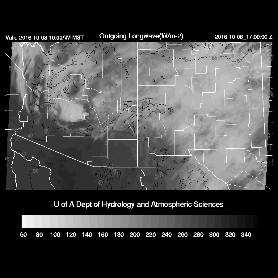
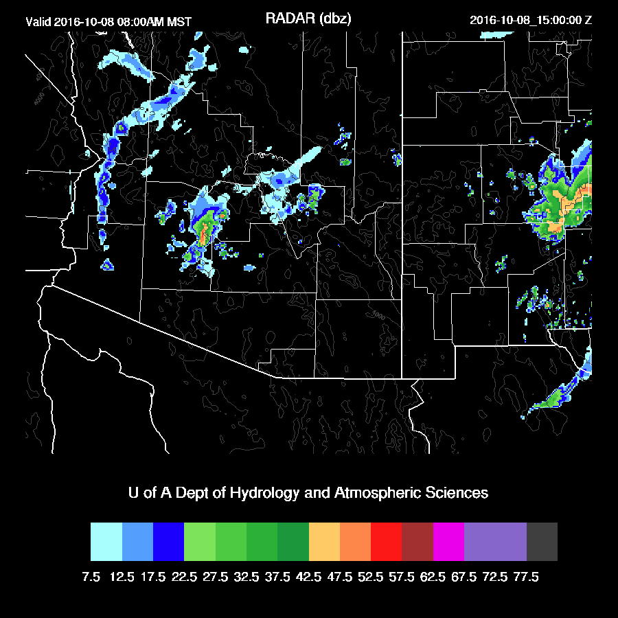
Another round of strong to possibly severe thunderstorms are possible over parts of the state tomorrow as moisture pools in the vicinity of a backdoor front. Activity gets off to an early start as a blob of moisture is forecast to be present over the Phoenix area around sunrise with some CAPE present.
surface_td_24.gif

Showers and few storms may form around 6-10am in the Phoenix vicinity.
mdbz_27.gif

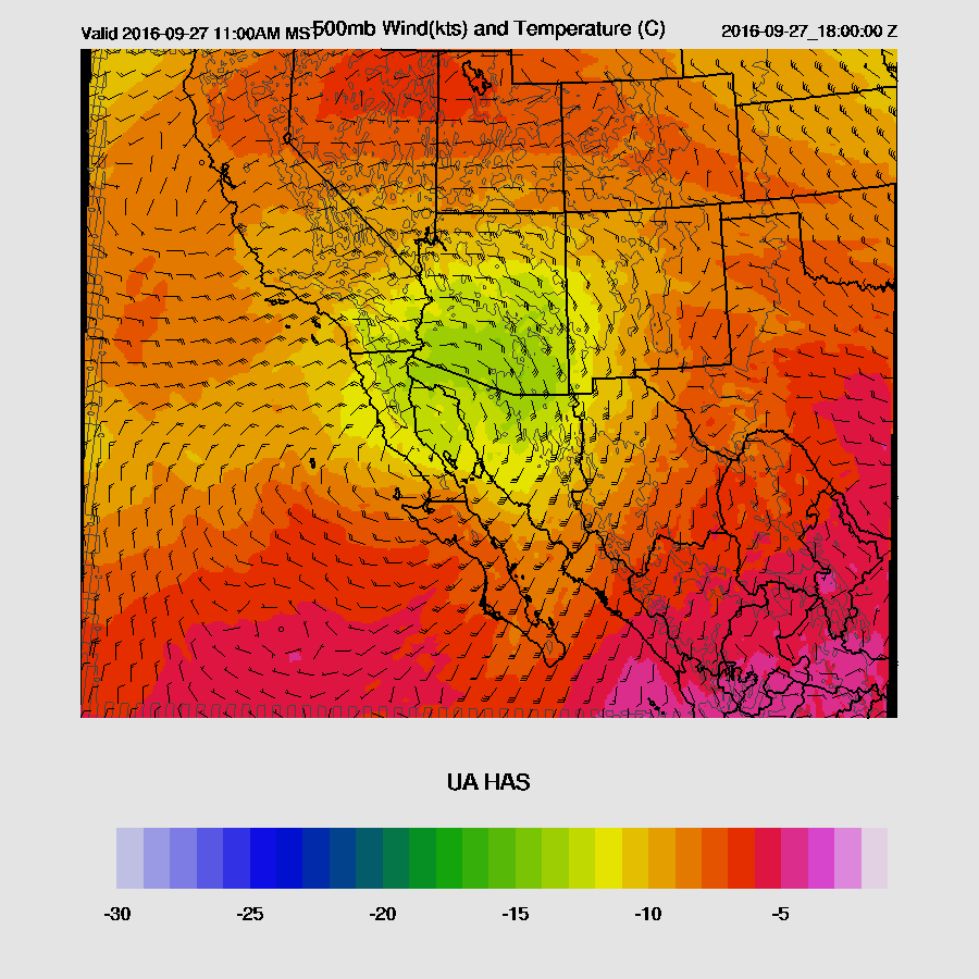
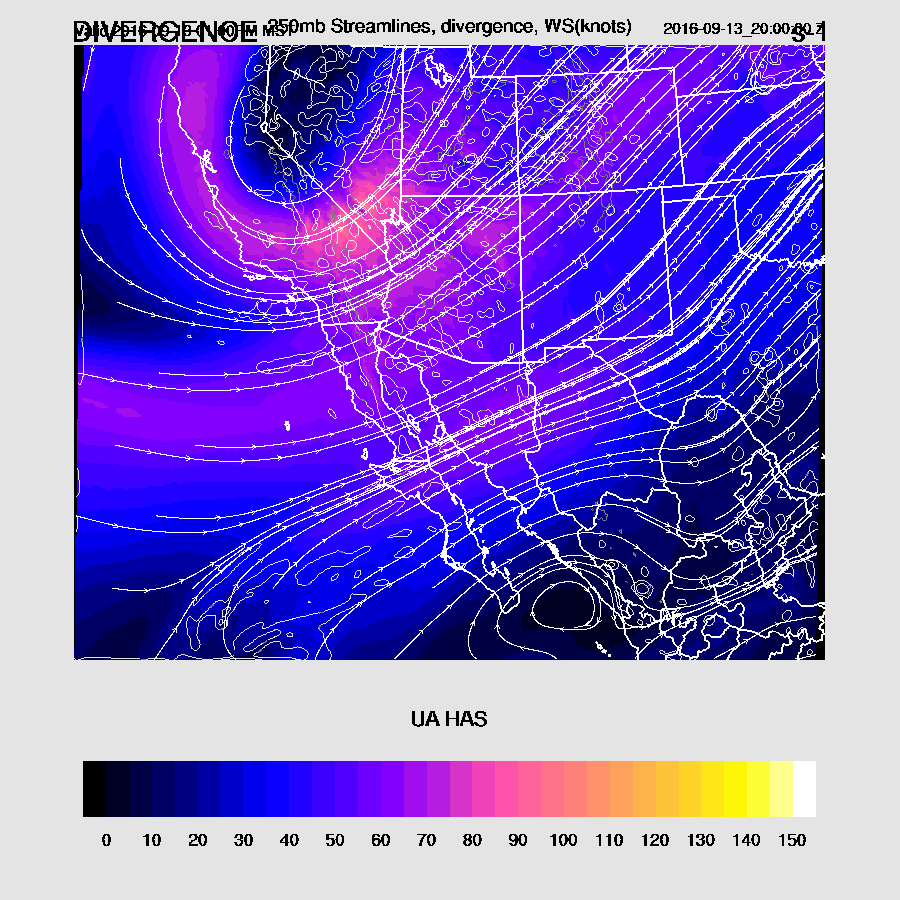
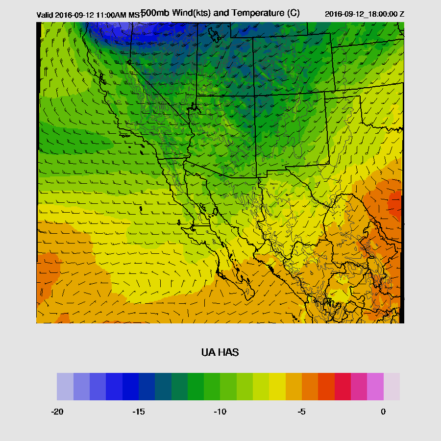
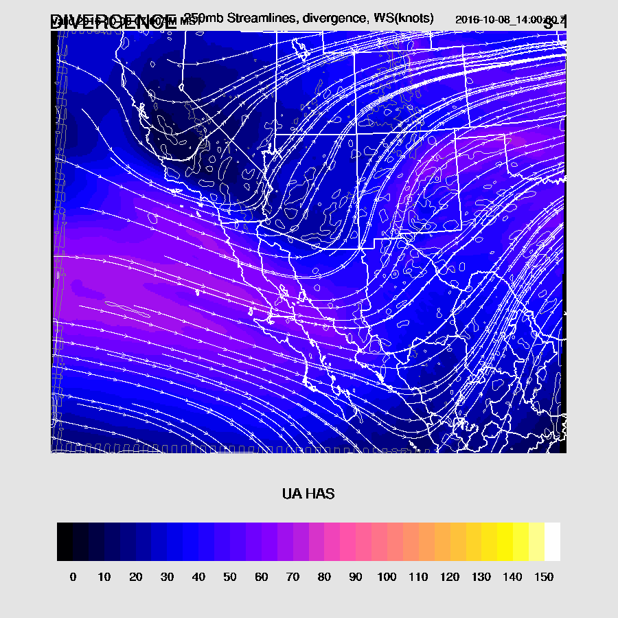
This activity is being forced by a weak trough over SW Arizona as upper divergence is quite strong along the trough axis.
250_32.gif
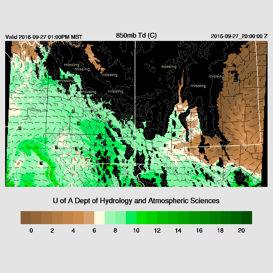
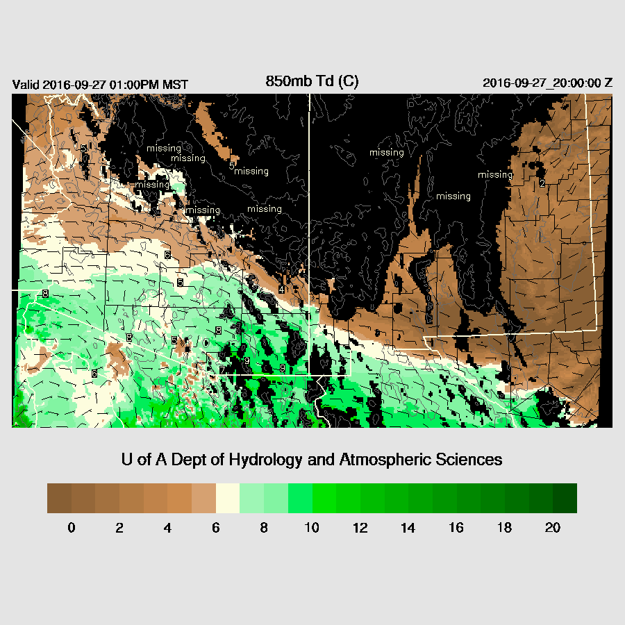
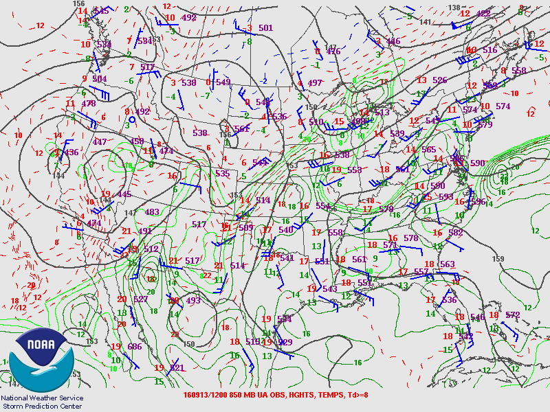
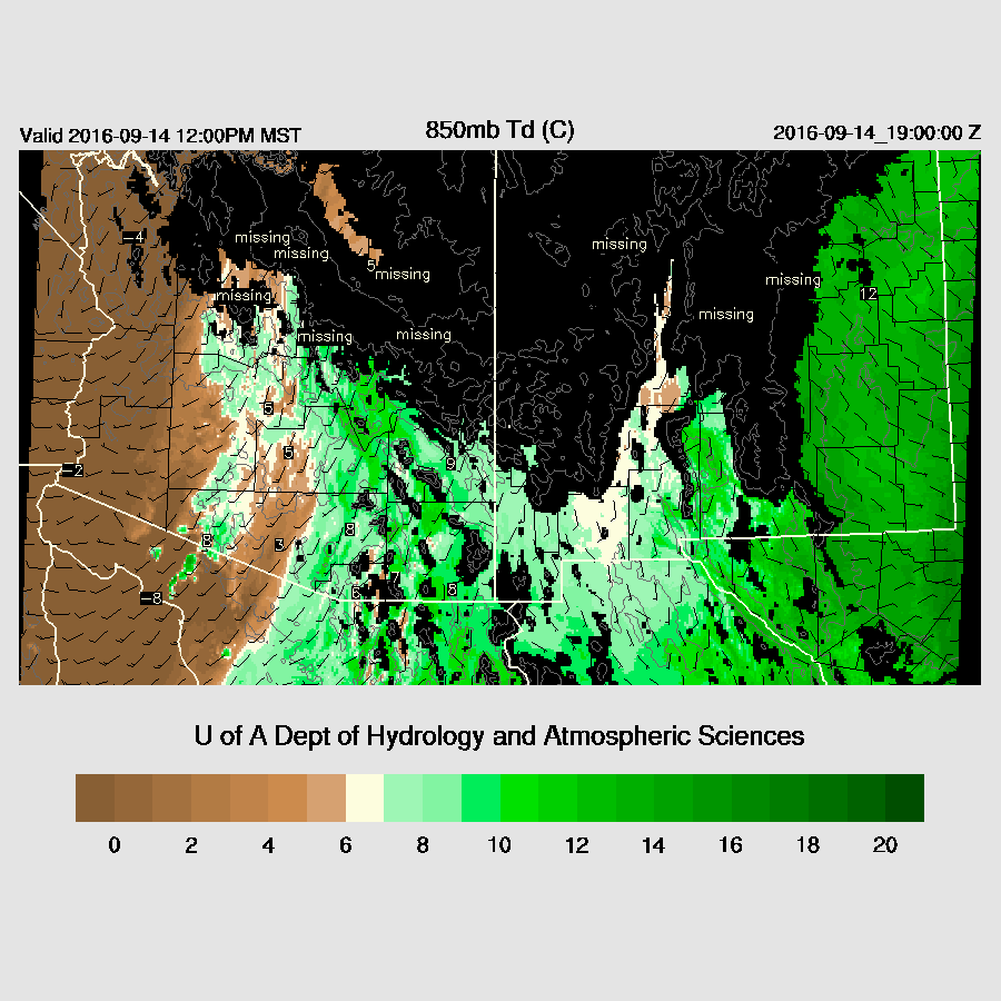
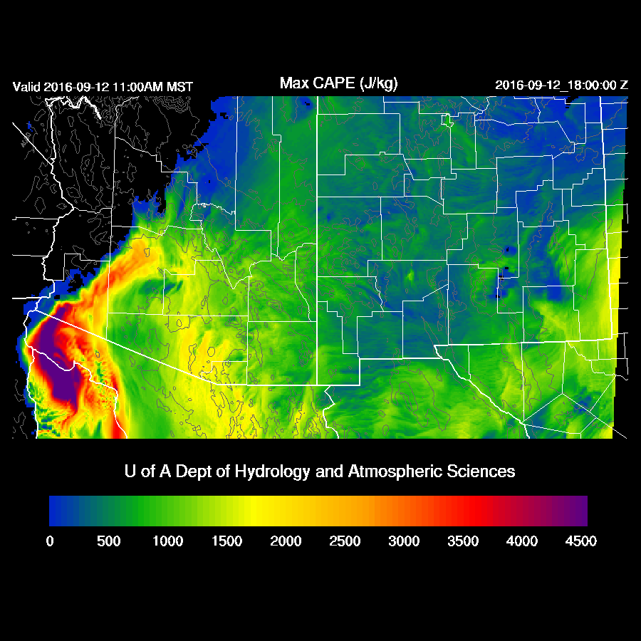
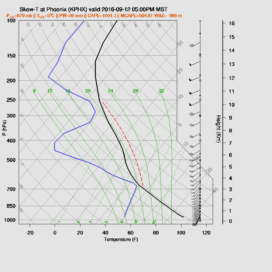
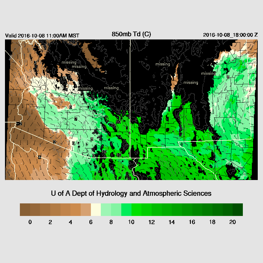
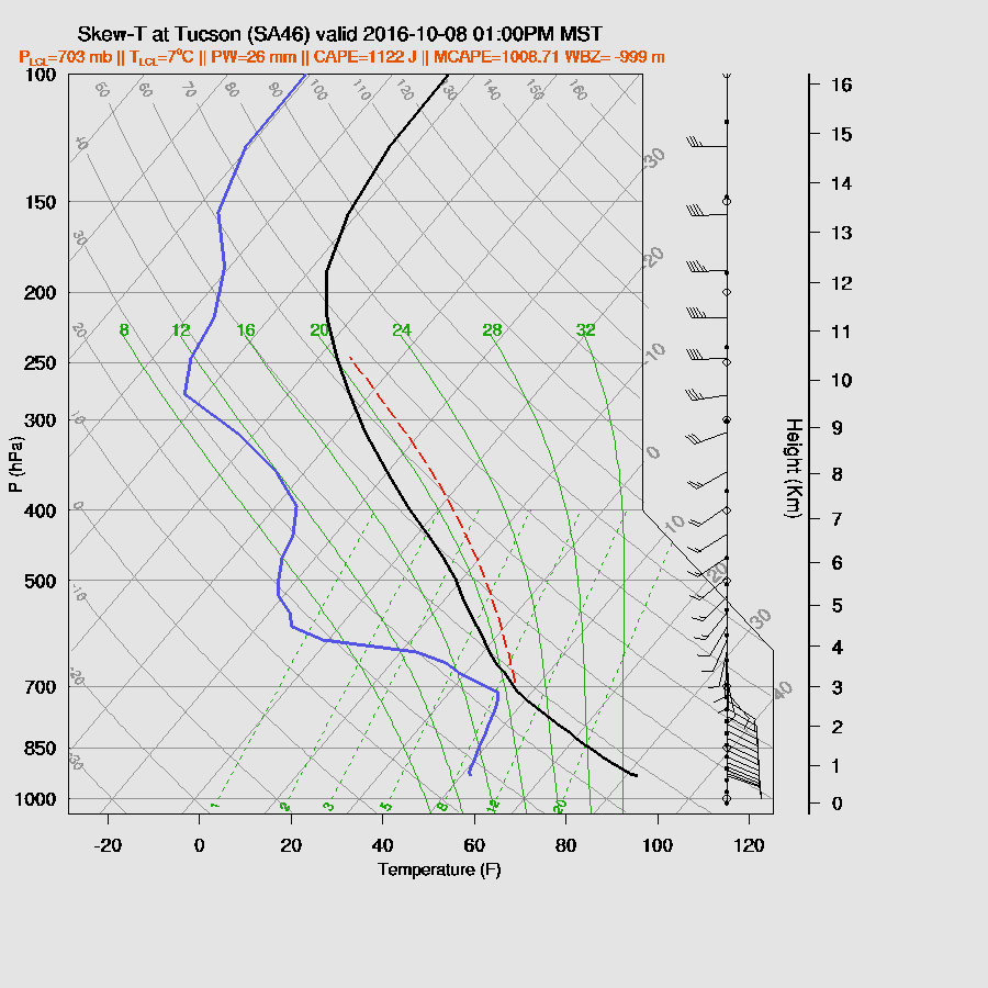
By early afternoon, moisture continues to increase over SE Arizona/SW NM with impressive 850 dewpoint temperatures around 10C.
850_30.gif
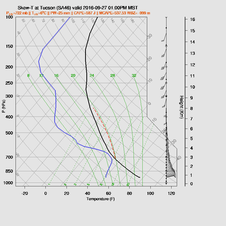
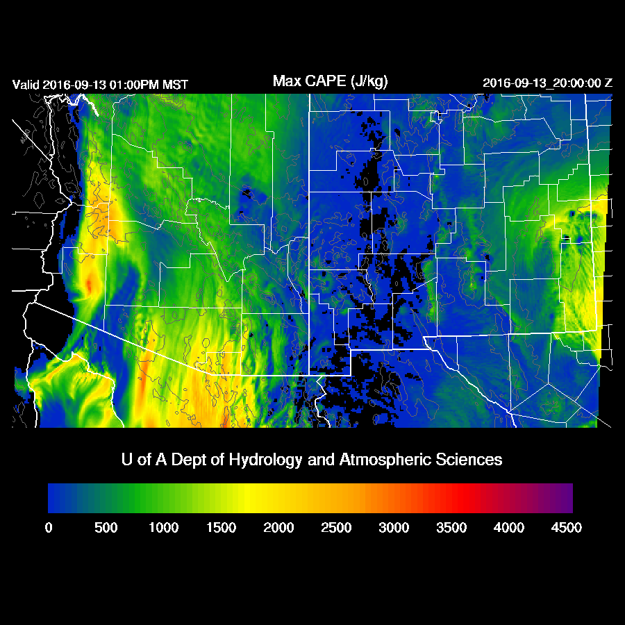
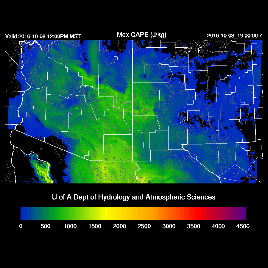
CAPE is also impressive with 1000 J/Kg and higher over SE Arizona.  CAPE is also present over the White Mountains up towards Flagstaff which will also support strong storms.
mcape_31.gif
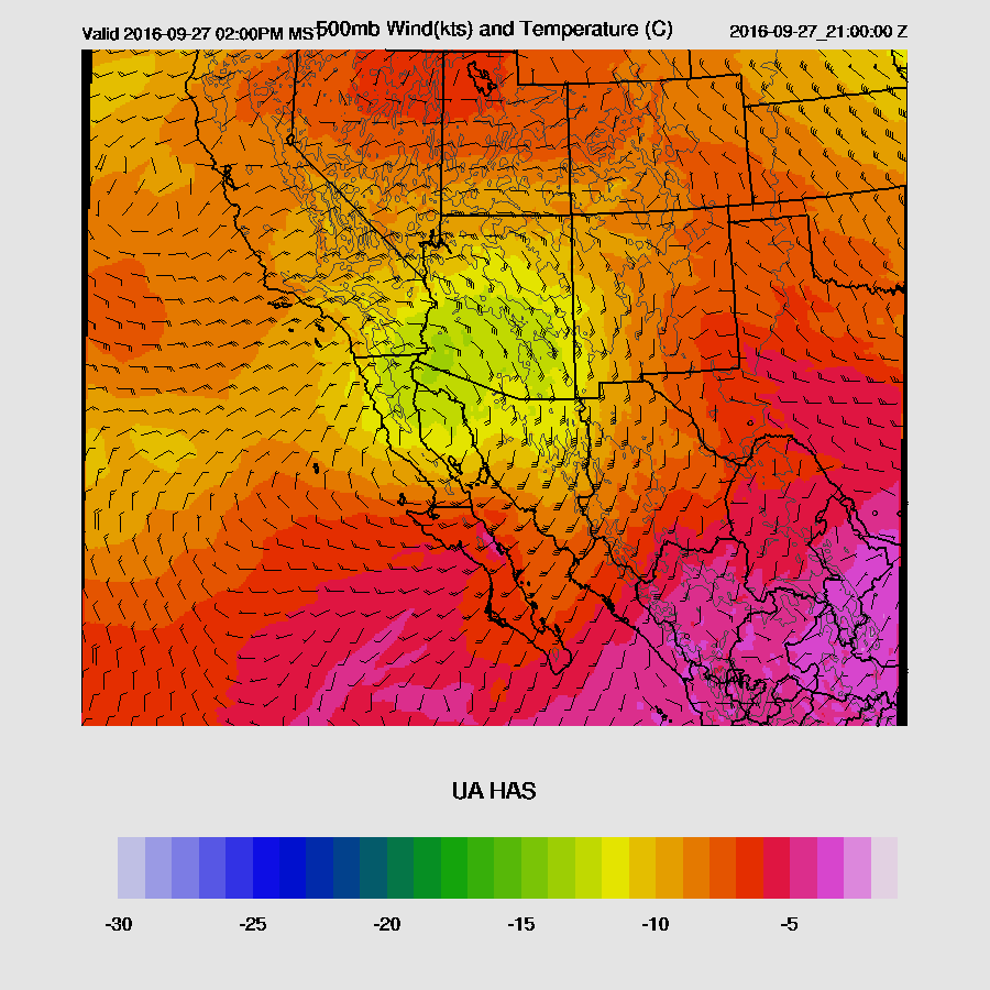
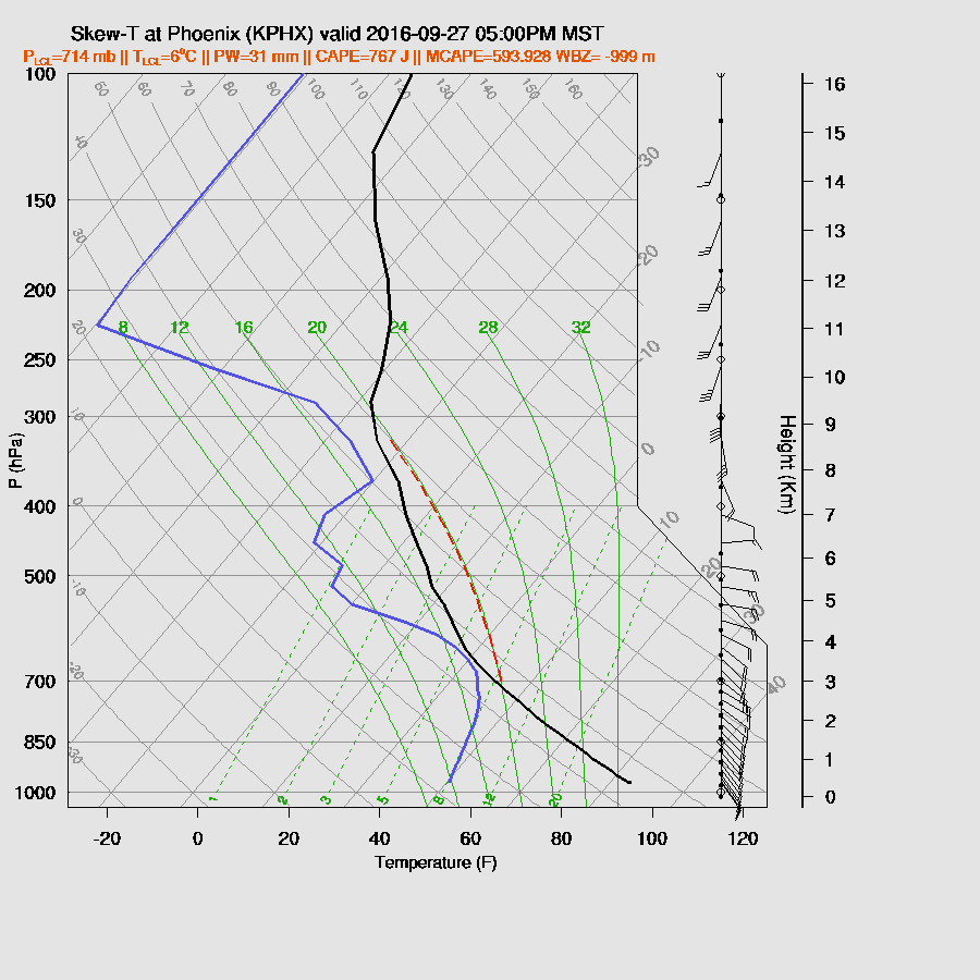
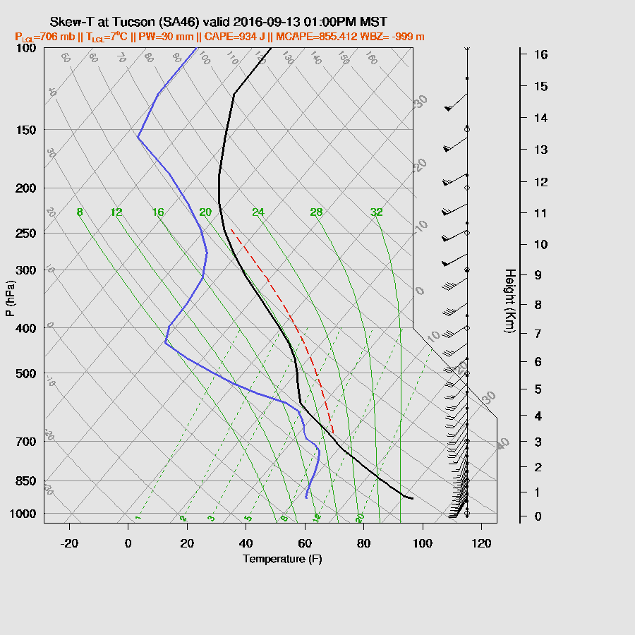
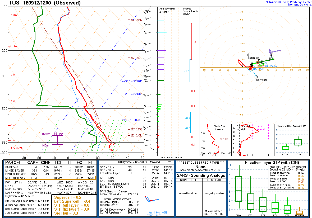
As Bob Maddox pointed out, the wind profile is excellent with strong directional shear and with 1000+ CAPE, strong to severe storms are likely with isolated strong wind and some hail possible.  This is one of the more impressive vertical profiles I’ve seen this transition season due to high CAPE and good directional shear.
skewt_1_32.gif

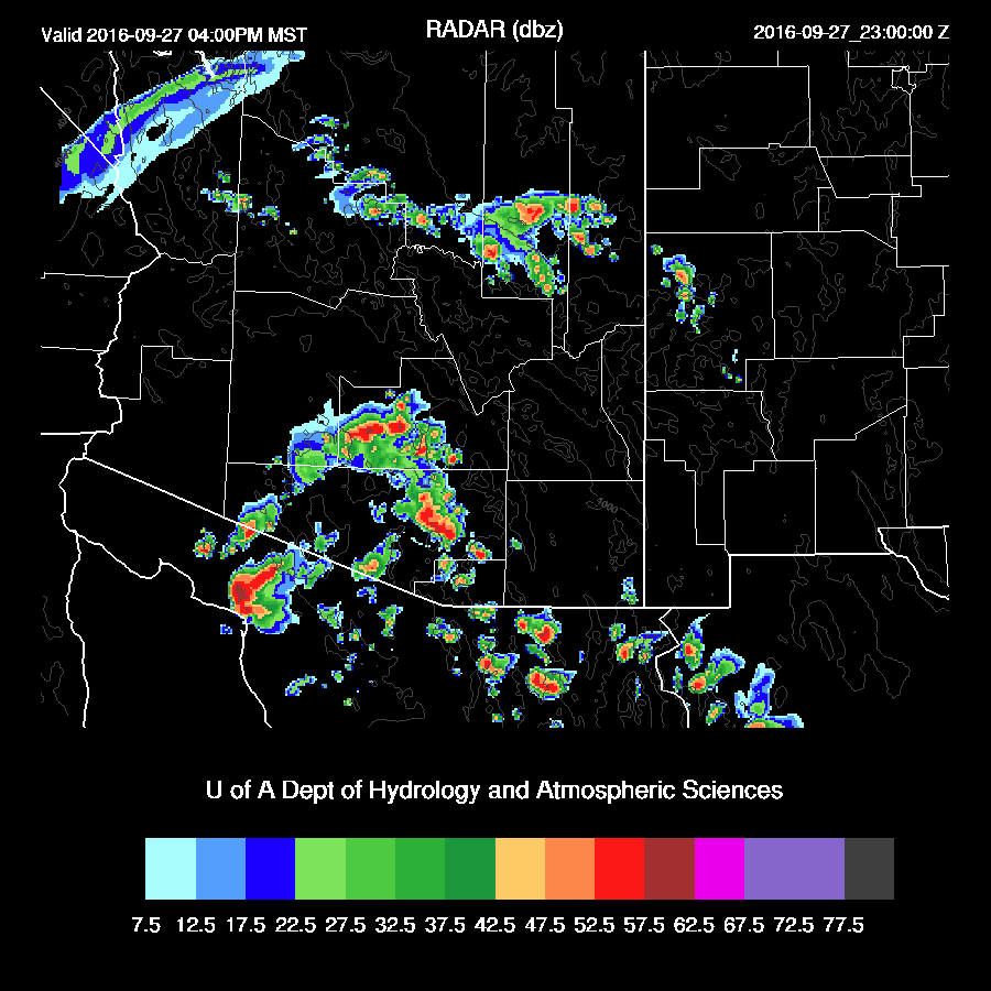
Deep convection develops over the high terrain of the Rim/White Mountains during the afternoon.
mdbz_33.gif
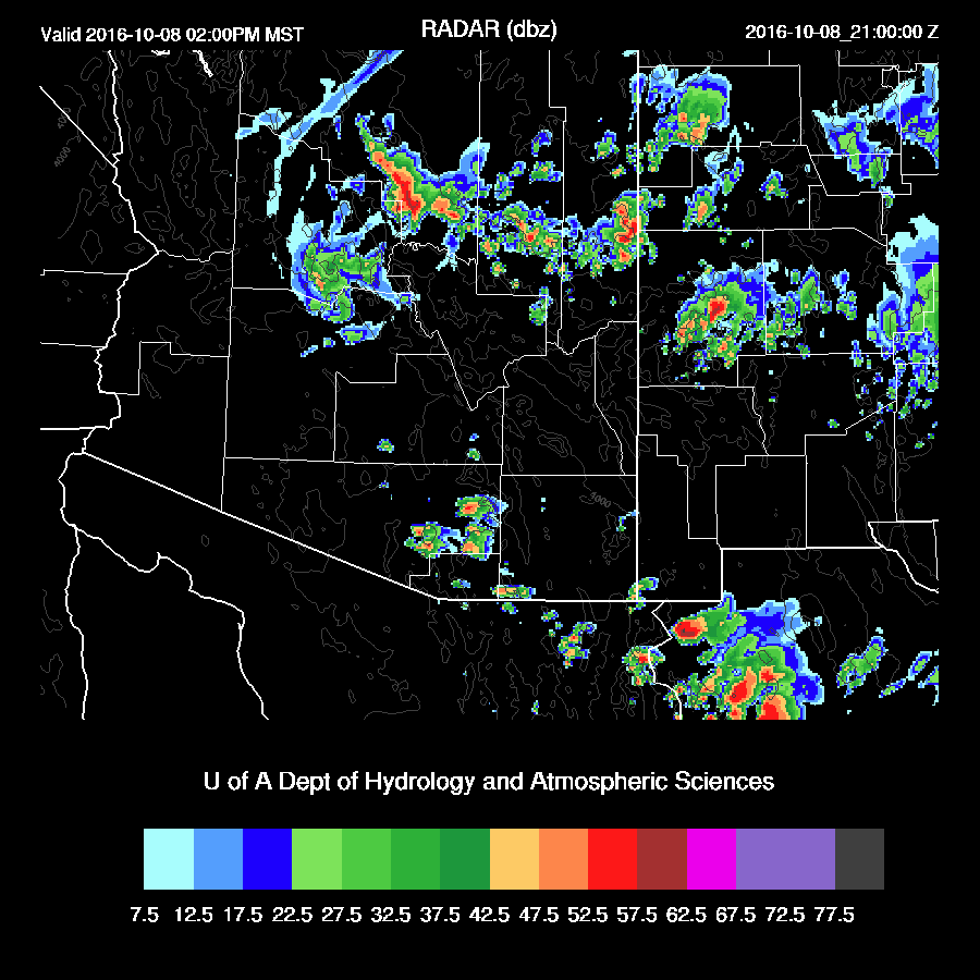
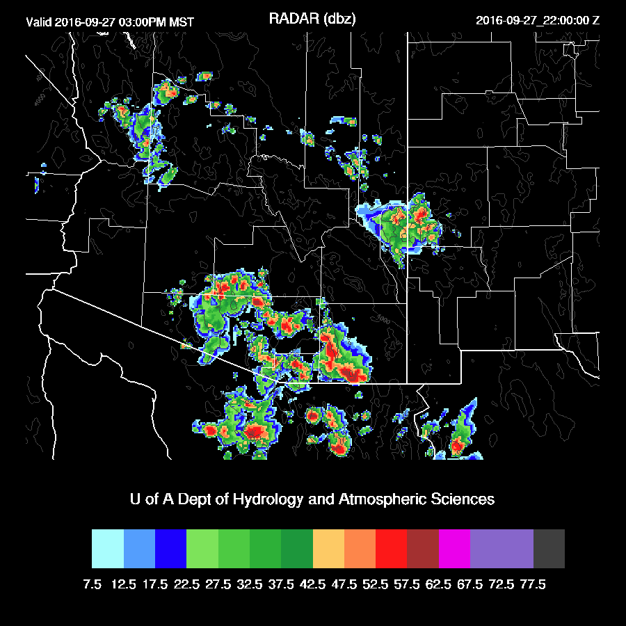
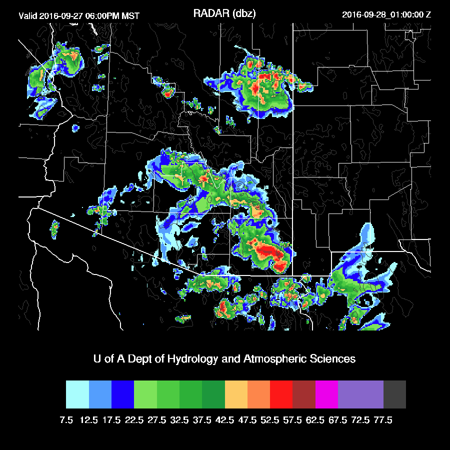
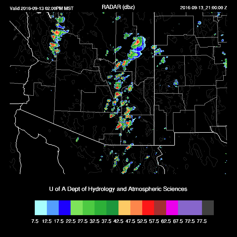
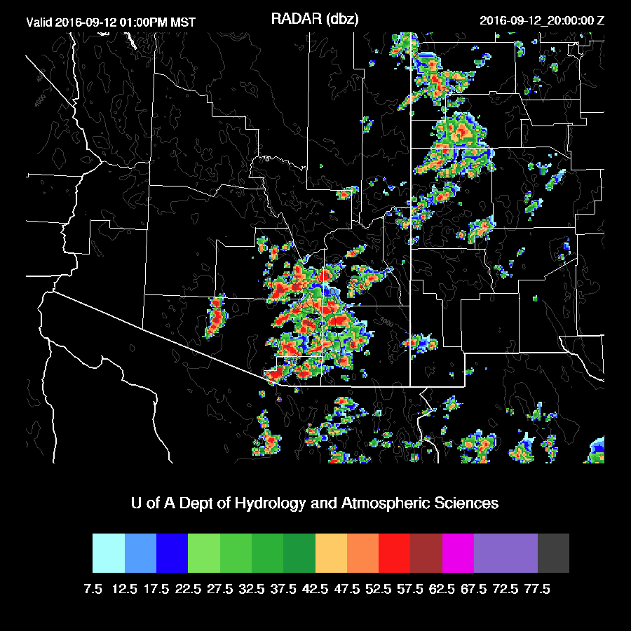
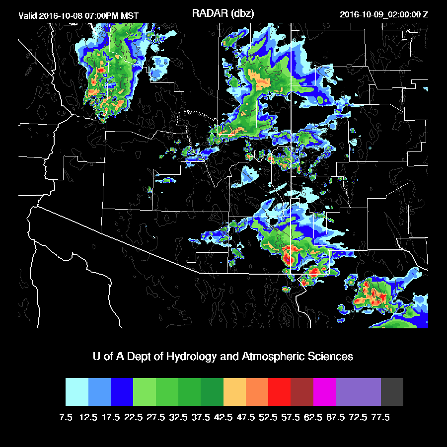
Later in the afternoon, deep convection forms over the higher terrain of SE Arizona.  Some of these storms become severe with the main threat being hail.  All the runs over the past 24 hours have been quite consistent with this solution.  The big question is if Tucson will see storms and the answer is unclear as some runs have storms in the valley while others (WRFNAM below) keep them over the higher terrain.
mdbz_35.gif

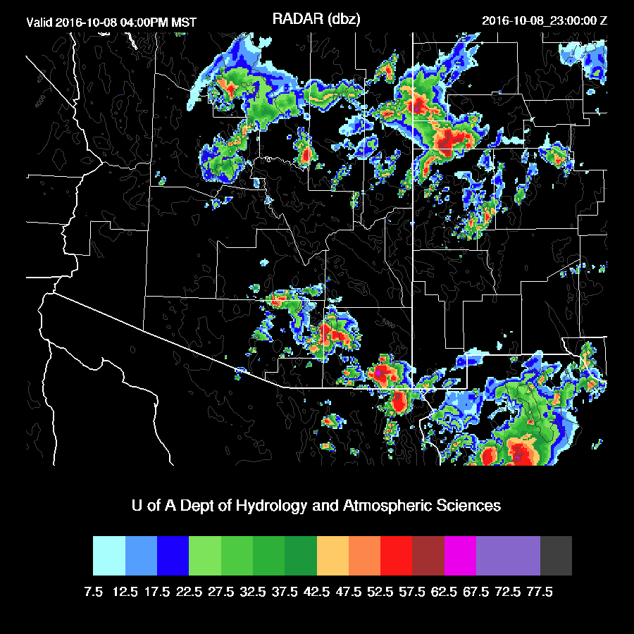
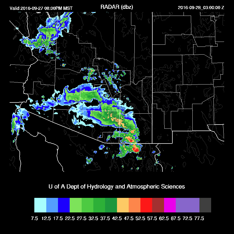
The WRFGFS does have strong storms in the Tucson valley and up into Pinal county by late afternoon.  So, the message is that some strong to severe storms are likely around SE Arizona, but exactly where is unclear.
mdbz_35.gif

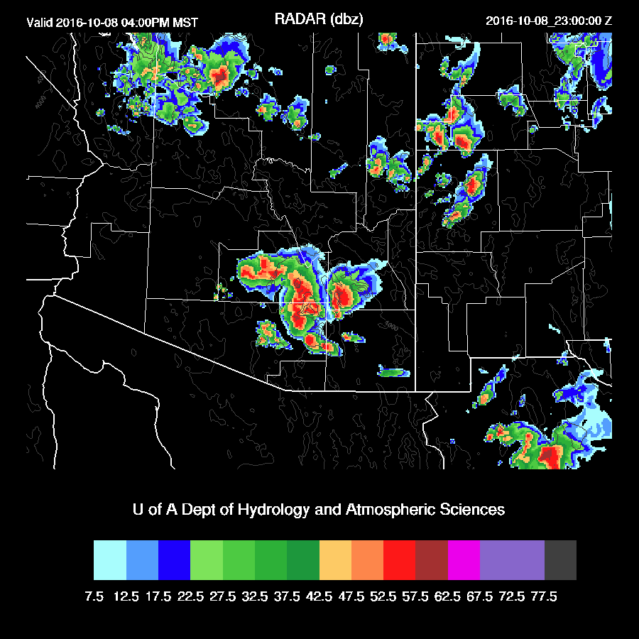
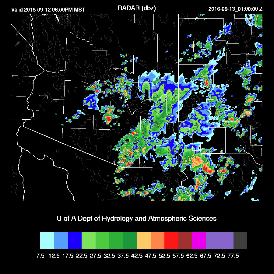
A few strong storms continue over far eastern Arizona into the early evening.
mdbz_38.gif

The concern, as it always seems to be, is if there will be clouds restricting heating during the morning hours.  This is definitely a possibility as morning storm activity is possible around Phoenix as well as a large area of clouds overnight.  These clouds are forecast to move out during the morning hours thus there is nearly full heating in the model.
mcin_29.gif

Tuesday, September 27, 2016

20160927

Initializations
The mid and upper low responsible for all the wind and rain is slowly moving northward and is located somewhere over the far northern Gulf of California-the analysis may be too far to the west. Showers and storms have been active on the east side of the low with ongoing activity from west of Douglas up through Tucson. Already, this has thrown a monkey wrench into the forecasts from yesterday and this morning as heating was required to obtain 500 J/Kg or so of CAPE. The 6Z and 12Z WRFNAM had a bit of activity this morning while the rest of the model runs had little or no clouds or shower activity. Unless it clears up in the next few hours, all the forecasts from the last 24 hours or so are going to have much less activity this afternoon than predicted.
2000-ATMO_Temp.png

Day 1
Both the 6Z and 12Z WRFNAM dissipate clouds and showers throughout the morning. There is some decrease in activity south of the border so perhaps the sun may break through later this morning in SE Arizona.
IRAZ.GIF

The 6Z WRFNAM had some activity over Santa Cruz county, but not nearly enough.
mcin_9.gif

By this afternoon, the 500mb low is forecast to be over the northern GofC. However, satellite imagery shows that the low is about 100 miles east of that position already at 15Z - another potentially significant error.
500_9.gif

The wettest air is over SE Arizona this afternoon. However, with limited sun, not much heating occurs and CAPE is minimal.
850_8.gif

Shear is about as good as it gets here with both directional and speed shear. The 6Z WRFNAM seems to have the best handle on the CAPE and it has only a few hundred J/Kg this afternoon.
The other extreme is the 12Z WRFNAM which has more heating, moisture, and CAPE. I find this to be less likely, but you never know as it might clear up later this morning.skewt_1_14.gif
All the runs continue to forecast deep convection developing over Pinal and Pima counties this afternoon. Areas that receive some heating will see scattered strong to isolated severe storms.  At this point, maybe areas of central Pima and western Pinal? It's really hard to say due to all the uncertainties in the model runs today (clouds, possible mid-level low position)skewt_1_8.gif
There is a chance of some activity in and around the Phoenix area as there is sufficient heating and moisture which results in 5-700 J/Kg of CAPE. The late afternoon wind profile isn’t quite as good as it is in SE Arizona but is still good enough to support some organized activity.mdbz_11.gif
skewt_2_12.gif

The models are split on activity around Phoenix. The WRFNAM is the most active and develops some showers and a few storms during the early evening.
mdbz_13.gif

As there is likely to be some big storms to the south of Phoenix, a haboob is also quite likely during the late afternoon. As seen in the above model sounding forecast, the PBL exhibits a decent inverted V profile.
wind10m_12.gif
A few storms develop during the early morning hours from Tucson northward.

mdbz_21.gif

Monday, September 26, 2016

20160926

This discussion will cover the potential for severe weather tomorrow.  An anomalous retrograding cut-off low has moved to a position over the Baja spur this morning. Guaymas is reporting a -12@ 500mb and the low was analyzed at 5760 m. There is a moderate amount of moisture to the south and east of the low in the range of 25-35 mm. Plus, there is a TS (Roslyn) at 119W, 17N moving slowly to the NE which may add additional moisture over the next few days.

By tomorrow, the low begins to eject to the north with quite cool mid level temperatures over southern Arizona of around -12 to -15C.
500_30.gif

Some low level moisture is present over southern Arizona with 850mb dewpoints in the 7-10 C range, which is fairly high for this time of year.
CAPE isn’t all that impressive, but the wind profile certainly is with a Great Plains supercell type of directional shear. Speed shear isn’t as good as was being forecast the other day but is still fair. The PBL becomes deeply mixed by early afternoon thus strong to severe storms are likely from around 1-4pm in and around the Tucson area. There is a risk of large hail. Storms are likely to exhibit rotation with the possibility of funnel clouds or maybe a brief tornado. The 12Z WRF GFS and WRF NAM model runs are quite similar thus there is some confidence in this forecast. The RR is missing at 12Z. I’ll check to see if there is any data available and make a run if that is the case.850_32.gif
skewt_1_32.gif

Deep convection initiates around 20Z over the higher terrain of central Pima and Santa Cruz counties. By mid-afternoon, a broken line of strong to severe storms moves to the NW and impacts Pinal, eastern Pima, and western Cochise counties. Again, both models are quite similar with location and timing. The WRFGFS, below, is about an hour faster than the WRFNAM and has strong storms in the Tucson area around 3-4pm.
mdbz_34.gif


Thunderstorm winds are expected to be strong with isolated areas of severe winds.
wind10m_34.gif

The broken line of storms continues to move to the north and northeast into the early evening.  At this point, the model runs diverge with the WRFGFS (below) moving the dissipating storms to the east of Phoenix and continuing strong storms over Cochise county plus another area of storms moving off of the White Mountains.
mdbz_37.gif

The WRFNAM is a few hours slower and has storms dissipating over Arizona by 8-9pm.
mdbz_39.gif


The storms move fairly quickly so rainfall isn’t extreme.  However, some locations could see over an inch or more.  Mode consistency has been remarkable as all the runs from that last 18 hours have nearly identical solutions.  Saying that, there are some issues that have to be monitored.  All model runs allow full heating tomorrow and as past history has shown, the model does have issues with insufficient clouds so if we wake up to clouds tomorrow, there may be much less activity than predicted.  
precip_tot_41.gif


Tuesday, September 13, 2016

20160913

Previous Day
A very active day for much of eastern Arizona as there were widespread thunderstorms, with some severe winds and large hail. Precipitation was heavy, but only for short periods as storm motion was quite rapid.

Both 6z runs were good as well as the 12z WRFNAM. The model runs were correct on predicting repeated development of storms throughout the afternoon as it rained 3 different times at my house. The 12Z WRFNAM had a bit too much precipitation, but location and timing were good. The 12Z WRFGFS had too much activity and was too far west (in and around Phoenix), as usual. It didn’t always use to be like this as a few summers ago, before the GFS upgrade, the WRFGFS (subjectively) performed as well or better than the WRFNAM.
http://www.atmo.arizona.edu/products/models/wrf_d02_old_2/precip_tot_24.gif

Initializations
Enough moisture has leaked into southern Arizona ahead of the west coast trough to support storms again today. Mid-level morning clouds are again present over central Arizona along with an area of high clouds over SW Arizona associated with a strong jet passing over the northern Baja mountains. The 6Z runs were mainly devoid of clouds while the 12Z NAM had some, but not enough. The RRx has been missing from ESRL the past few days.

A fairly strong area of low pressure is present at 850mb over southern NV is helping to advect moisture into the eastern part of the state.
http://www.spc.noaa.gov/obswx/maps/850_160913_12.gif

There were no major IPW initialization errors by any of the 6 or 12Z runs. Again, clouds are an issue over central Arizona. However, this shouldn’t impact the forecast much as low-level moisture is insufficient. The model runs should perform well across eastern Arizona.

Day 1
Moisture continues to advect into southern Arizona ahead of a strong west coast trough. The model runs from yesterday had much drier air across the state for today, but the wet air was never far away in Mexico and it doesn’t take much to advect it into the state. Goes to show you how quickly the forecast can change. By late morning, there is significant low-level moisture over southeastern Arizona as dewpoint temperatures are above 10C.  
http://www.atmo.arizona.edu/products/models/wrf_d02_2/850_8.gif

The model runs disagree where the most unstable air is located. The WRFNAM has it over far SE Arizona while the WRFGFS (below) is most unstable over Santa Cruz/eastern Pima. A close look at the 15Z Suominet data indicates that the WRFGFS seems to have the best handle on the moisture as the WRFNAM is too wet over Cochise county. However, it is quite wet due south of Cochise county at Moctezuma (PW is 31mm). In fact, all of northern Sonora has IPW values in the low to mid 30mm range. WRFGFS below.
http://www.atmo.arizona.edu/products/models/wrf_d02_3/mcape_8.gif

Are we going to have a repeat of yesterday? Early afternoon CAPE around Tucson is around 900 J/Kg and the PBL is mixed deeply. What is different from yesterday is that the directional shear is somewhat less by early afternoon. Speed shear in the WRFGFS (below) is a bit better with mid-level winds about 5-15 knots stronger, but the WRFNAM winds are similar to yesterday.  So, it’s looking favorable again for fast moving and organized convection from Tucson and to the east, Hail is again a possibility.
http://www.atmo.arizona.edu/products/models/wrf_d02_3/skewt_1_8.gif


The 2 12Z runs are nearly identical in developing deep convection during the early afternoon N/S of Tucson as well as over NW Arizona where there was also sufficient CAPE.
http://www.atmo.arizona.edu/products/models/wrf_d02_3/mdbz_9.gif


Big storms continue to develop and move to the NE along this line throughout the afternoon.  Quite similar to yesterday but offset to the east by about 50-100 miles.

http://www.atmo.arizona.edu/products/models/wrf_d02_2/mdbz_11.gif

In some ways, today looks even better for severe weather as there is more upper support as a strong jet associated with the trough moves towards the state. Upper difluence and divergence are present over much of the state during the afternoon.
http://www.atmo.arizona.edu/products/models/wrf_d01_2/250_8.gif

Wet air continues over the eastern part of the state into the evening.
http://www.atmo.arizona.edu/products/models/wrf_d02_2/850_13.gif

As they did last night, storms continue into the evening hours, east of Tucson.
http://www.atmo.arizona.edu/products/models/wrf_d02_3/mdbz_15.gif

Note that storms redevelop over the same locations throughout the day into the evening.  Some areas could get quite a bit of rain, like the mountains around Tucson.
http://www.atmo.arizona.edu/products/models/wrf_d02_2/precip_tot_17.gif

Day 2
Some moisture continues to hang around eastern Arizona but should be insufficient to support much deep convection.
http://www.atmo.arizona.edu/products/models/wrf_d02_2/850_31.gif

Monday, September 12, 2016

20160912

12Z WRFGFS Update
The WRFGFS initialized OK with only minimal IP errors. Like the other runs, it did not have enough clouds and at 17Z, scattered to broken mid level clouds continue over central Arizona. IPW was initialized well.

I wanted to mention the 12Z WRFGFS as it's much more active around Phoenix this afternoon as forecast CAPE is much higher than the WRFNAM.


Strong storms develop over much of northern Maricopa county during the mid to late afternoon. My two big concerns with this forecast are the clouds that continue to be present that may restrict heating and the over-prediction of deep convection that has been typical of the WRFGFS this summer. So, I find the below unlikely and the coverage/intensity should be less and perhaps somewhat later in the day.


I took a quick look at predicted vs observed IPW at 16:45Z and the WRFGFS is definitely too wet west of Phoenix and even the WRFNAM is 2-3mm too wet over much of SW and southcentral Arizona. I've been unable to initialize off of the RR this morning and may go try again in order to see what it says. At this point, the WRFNAM is likely to be too early with deep convection and perhaps too widespread too.


Previous Day
Yesterday’s WRF runs produced deep convection mainly over far SE Arizona which was close to observed. Precipitation developed northeast of Phoenix early this morning which was not forecast by any of the model runs.


Initializations
An elevated unstable layer is present on the morning sounding with over 1000 J/Kg of CAPE.  This instability has already triggered deep convection to the NE of Phoenix, which was not handled well by the overnight model runs. The 12z NAM is also missing this convection and the associated cloud cover.


The NAM had a moderate wet bias in Sonora this morning probably due to the bad sounding data there. Other than that, only minor errors. I’m not waiting for the 12z WRFGFS as I need to get this discussion finished quickly due to the early start of the activity, so I’ll also use the WRFGFS from 6Z. Its IPW was initialized well. Overall, the model initializations are fair and confidence is medium.  


Day 1
A weak shortwave trough is passing through Arizona today with an area of cooler mid level air (below -10C) that can be seen over eastern Arizona by late morning.


Low-level moisture has increased significantly over the eastern ½ of the state with late morning 850mb dewpoint temperatures in the 11 to 13C range.  


CAPE is forecast to be over 1500 J/Kg in eastern Pima county with higher amounts off to the west. With CAPE this high and cool air aloft, hail is a possibility with storms today.


The Tucson forecast skew-t indicates over 1300 J/Kg of CAPE and a well-mixed PBL by around mid-day. This should lead to early afternoon deep convection. The wind profile has some directional shear thus some organization is possible, and with CAPE this high, some very strong to severe storms are possible.


It looks like eastern Pima/western Cochise become very active by early afternoon (12z WRFNAM below). The 6Z WRFGFS is similar except for an hour or two later.  In fact, all the model runs over the past 24 hours have been very similar thus confidence is high.


Storms move off to the NE quite fast as mid level flow is around 20-30 knots.  Additional storms form on the edges of the outflows from the initial activity.


Besides hail, isolated very strong winds are a possibility with the storms.


By late afternoon, the PBL is very deeply mixed at Phoenix, but CAPE is somewhat lacking with about 500 J/Kg (CAPE is not calculated correctly on the skew t below). If storms can form, they will have a high risk of very strong winds.


The WRFNAM does have isolated storms around Pinal and eastern Maricopa late this afternoon and early evening. Also, note the redevelopment of some activity over eastern Pima county.  Both the 6z WRFGFS and 12Z WRFNAM (below) are similar.


Day 2
Drier air returns with the only moisture of significance over SE Arizona.


Only an isolated storm or two during the late afternoon.