12Z WRFGFS Update
The WRFGFS initialized OK with only minimal IP errors. Like the other runs, it did not have enough clouds and at 17Z, scattered to broken mid level clouds continue over central Arizona. IPW was initialized well.
I wanted to mention the 12Z WRFGFS as it's much more active around Phoenix this afternoon as forecast CAPE is much higher than the WRFNAM.

Strong storms develop over much of northern Maricopa county during the mid to late afternoon. My two big concerns with this forecast are the clouds that continue to be present that may restrict heating and the over-prediction of deep convection that has been typical of the WRFGFS this summer. So, I find the below unlikely and the coverage/intensity should be less and perhaps somewhat later in the day.

I took a quick look at predicted vs observed IPW at 16:45Z and the WRFGFS is definitely too wet west of Phoenix and even the WRFNAM is 2-3mm too wet over much of SW and southcentral Arizona. I've been unable to initialize off of the RR this morning and may go try again in order to see what it says. At this point, the WRFNAM is likely to be too early with deep convection and perhaps too widespread too.
The WRFGFS initialized OK with only minimal IP errors. Like the other runs, it did not have enough clouds and at 17Z, scattered to broken mid level clouds continue over central Arizona. IPW was initialized well.
I wanted to mention the 12Z WRFGFS as it's much more active around Phoenix this afternoon as forecast CAPE is much higher than the WRFNAM.


Previous Day
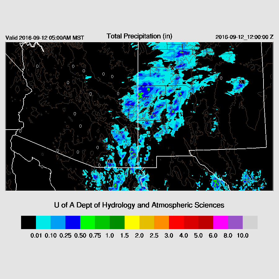
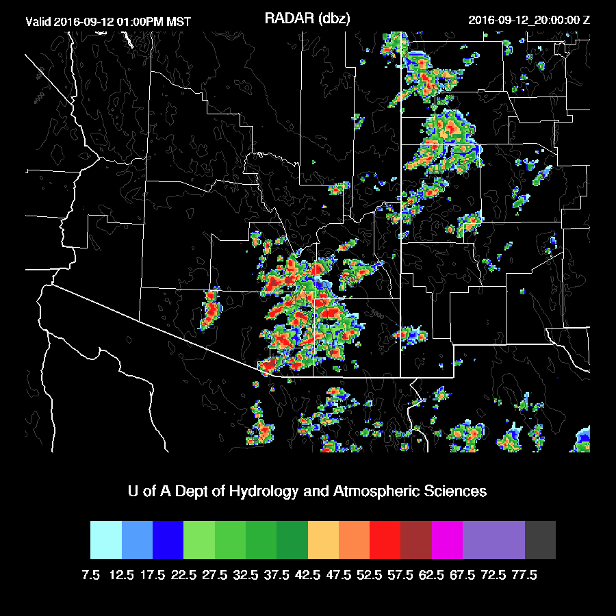
Yesterday’s WRF runs produced deep convection mainly over far SE Arizona which was close to observed. Precipitation developed northeast of Phoenix early this morning which was not forecast by any of the model runs.

Initializations
An elevated unstable layer is present on the morning sounding with over 1000 J/Kg of CAPE. This instability has already triggered deep convection to the NE of Phoenix, which was not handled well by the overnight model runs. The 12z NAM is also missing this convection and the associated cloud cover.
The NAM had a moderate wet bias in Sonora this morning probably due to the bad sounding data there. Other than that, only minor errors. I’m not waiting for the 12z WRFGFS as I need to get this discussion finished quickly due to the early start of the activity, so I’ll also use the WRFGFS from 6Z. Its IPW was initialized well. Overall, the model initializations are fair and confidence is medium.
Day 1
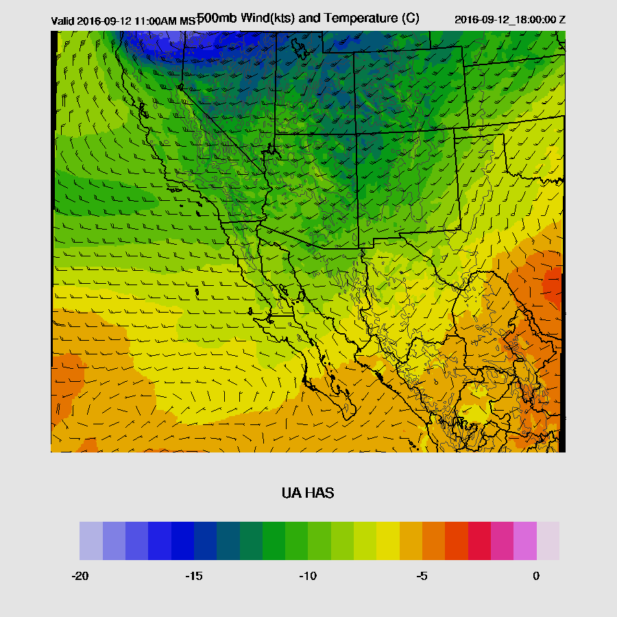
A weak shortwave trough is passing through Arizona today with an area of cooler mid level air (below -10C) that can be seen over eastern Arizona by late morning.
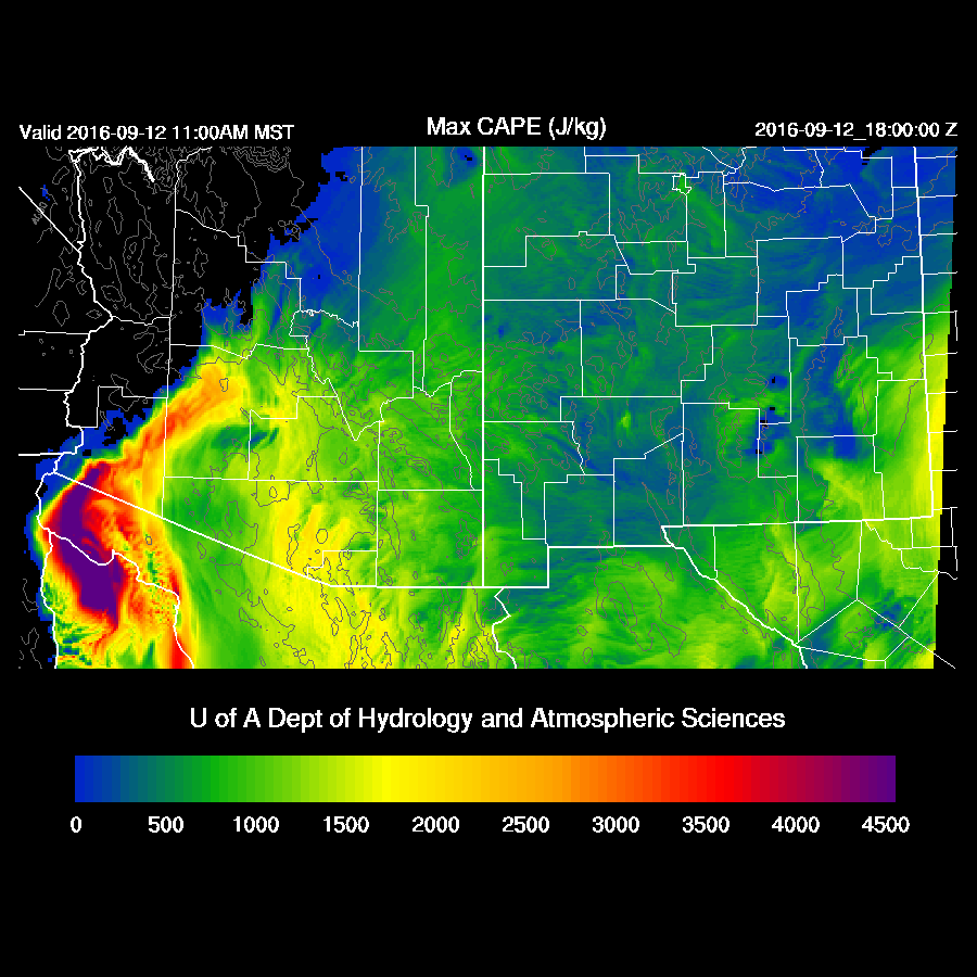
Low-level moisture has increased significantly over the eastern ½ of the state with late morning 850mb dewpoint temperatures in the 11 to 13C range.

CAPE is forecast to be over 1500 J/Kg in eastern Pima county with higher amounts off to the west. With CAPE this high and cool air aloft, hail is a possibility with storms today.
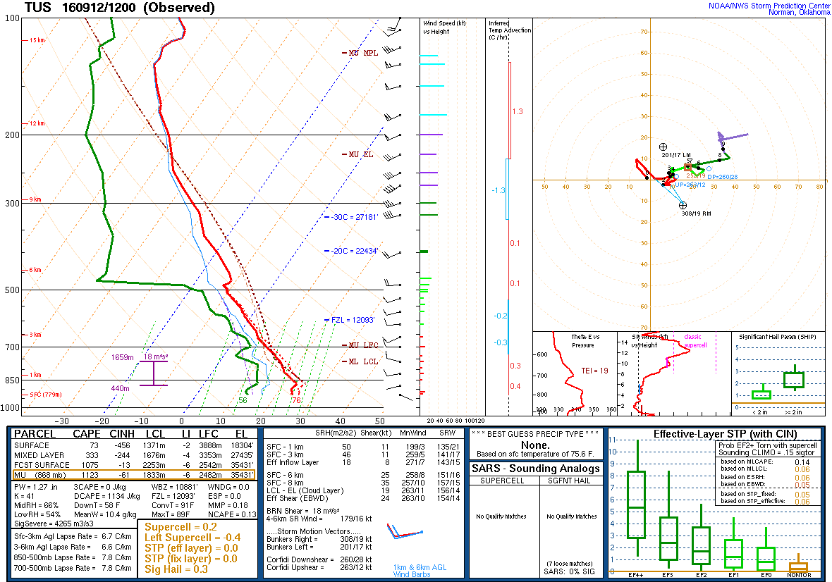
The Tucson forecast skew-t indicates over 1300 J/Kg of CAPE and a well-mixed PBL by around mid-day. This should lead to early afternoon deep convection. The wind profile has some directional shear thus some organization is possible, and with CAPE this high, some very strong to severe storms are possible.

It looks like eastern Pima/western Cochise become very active by early afternoon (12z WRFNAM below). The 6Z WRFGFS is similar except for an hour or two later. In fact, all the model runs over the past 24 hours have been very similar thus confidence is high.
Storms move off to the NE quite fast as mid level flow is around 20-30 knots. Additional storms form on the edges of the outflows from the initial activity.

Besides hail, isolated very strong winds are a possibility with the storms.

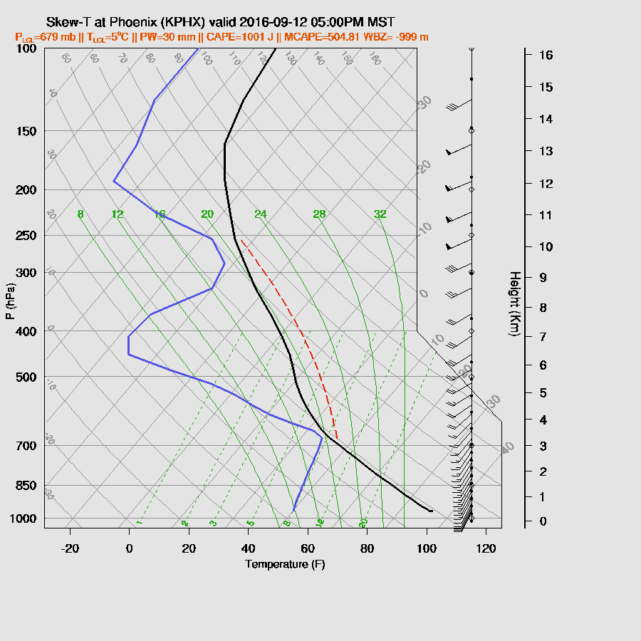
By late afternoon, the PBL is very deeply mixed at Phoenix, but CAPE is somewhat lacking with about 500 J/Kg (CAPE is not calculated correctly on the skew t below). If storms can form, they will have a high risk of very strong winds.
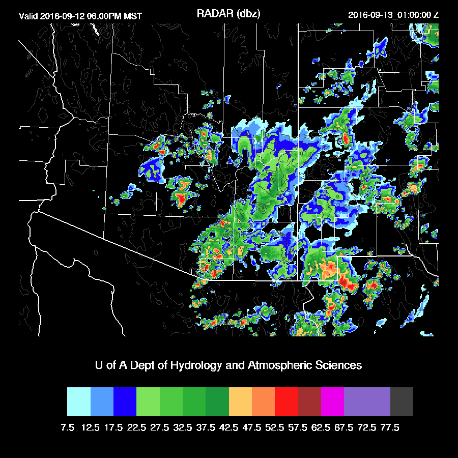
The WRFNAM does have isolated storms around Pinal and eastern Maricopa late this afternoon and early evening. Also, note the redevelopment of some activity over eastern Pima county. Both the 6z WRFGFS and 12Z WRFNAM (below) are similar.
Day 2
Drier air returns with the only moisture of significance over SE Arizona.

Only an isolated storm or two during the late afternoon.

I am Alecia used every single spell worker on the internet, spent untold amounts of money and discovered they are all fakes…i was the fool though; doing the same thing over and over again and expecting different results. In the end, I decided that I wanted a tarot reading to know what my future held for me; I contacted a woman who lives locally to me and she told me about a man named (Dr Abalaka); he does not advertise on the internet, has another job for income, has no set prices, makes no false promises and refuses to help anyone that cannot be helped and even helps for free sometimes, he will give you proof before taking money. He is a wonderful man and he was the only person who actually gave me real results. I really hope he doesn’t mind me advertising his contact on the internet but I’m sure any help/ extra work will benefit him.contact him as dr.abalaka@outlook.com He travel sometimes.love marriage,finance, job promotion ,gambling voodoo,lottery Voodoo,poker voodoo,golf Voodoo,Law & Court case Spells,money voodoo,weigh loss voodoo,any sicknesses voodoo,Trouble in marriage,it’s all he does Hope this helps everyone that is in a desperate situation as I once was; I know how it feels to hold onto something and never have a chance to move on because of the false promises and then to feel trapped in wanting something
ReplyDeletemore. his cell phone number 5182932141 !