Tuesday, September 8, 2020

20200908

 Discussion

An unusually strong trough is dropping south into Arizona this morning and will interact with a little moisture that has moved into the state from Mexico.  

Initially, I wasn't going to write a discussion as moisture was forecast to be limited, but that has changed.  Moisture increased to 36mm overnight and is currently still quite high, at 28mm.  Phoenix has increased to around 28mm too.  MLCAPE is very impressive at 2200 J/kg, but there is a gradual inversion from 850 to just above 700mb.  There isn't much shear to speak of, but as you go north, it improves considerably.

One of the big unknowns today is all the smoke.  There is so much over central and southern Arizona that it is acting like a thin overcase of normal clouds.  We use the NASA GEOS5 AOD product in WRF, but it was unable enough reduction in solar irradiance.  This reduction is likely to keed temperatures a few degrees below the forecast highs, which may impact any possible convective development.

Day 1

Strong southerly flow ahead of the approaching trough continues to advect moderate amounts of moisture into southern Arizona.  The front continues to push south, ressulting in mosture convergence along the boundary. 

CAPE also increases and is very high in a narrow stripe, just ahead of the front.  We'll see in a little bit what the cap/inversion looks like.

It's going to be close at Phoenix!  The cap slowly erodes away during the early afternoon, resulting in a narrow window where deep convection and severe storms are possible.  CAPE is a high 1800-2400 J/kg, along with some directional and speed shear.  The slight reduction in surface heating due to the smoke may make a difference between storms and no storms, at least in the Phoenix area.

My guess is that no storms will form as none of the dertimistic runs have any.  Add in the issue with the heating, and that makes it even more unlikely.  Still, with the above sounding, one can't rule them out.  Storms do develop just north of Phoenix and over far southeastern Arizona during the afternoon hours.

 A few runs develop deep convection just to the east of Phoenix.  I took a look at the HRRR and it was very similar.  the HRRRx was more like the WRFGFS and WRFNAM which kept deep convection farther to the northeast of Phoenix.

Strong to severe storms continues over far eastern Arizona into the evening.

Day 2
The trough becomse a cutoff closed low over northern Arizona.

The front stalls out over southeatern Arizona, and ahead of it, moisture and CAPE continue to be sufficient for some storm activity, especially in southwestern NM.


Monday, August 31, 2020

20200831

Previous Forecast

Most precipitation occurred west of Tucson and Phoenix.  

Some good, some bad.  The WRFGFS was, by far, the best run as it had both the activity that moved north from western and central Pima County and the activity west though north of Phoenix.  It also did not have any activity this morning in the Tucson area, which also verified.  The bad was the WRFNAM (and some earlier WRFGFS) forecasts for a heavy rain event for Tucson.  Tucson awoke to mostly sunny skies!  The WRFRR had issues as it completely missed the central/western Pima County activity.  The HRRR wasn't anything special either as no storms materialized in eastern Pima County and there was no strong activity in Phoenix.  The storms got close but fizzled as they moved into the valley.  The HRRRx had nothing west of Phoenix.

Discussion

This is really hard to take having all the moisture around and having little or nothing happen in the Phoenix and Tucson areas.  Even worse is how the model runs are teasing us with their forecasts for big events for the next day and then having the rug pulled out.  I'm ready for the end of the monsoon.  

It looks like that's it for the moisture from the tropical systems as dry air has moved south over western Arizona and PW has decreased significantly.  The only moist air is over far SW Arizona and into southern Arizona.  

CAPE is back down to zero at Phoenix.  Tucson is better, but not great at 750 J/kg of MLCAPE.  The profile is nearly saturated to just above 500mb where a strong cap exists.   This cap is probably the reason that none of the WRF forecasts for heavy rain verified.  Winds around 700mb are still southeasterly so a weak IT is still located somewhere to the south.

The 500mb ridge continues to flatten and move south and winds over Arizona continue to be southwesterly.  A weak jet continues south of a weak trough over NW Arizona.   Temperatures have increased and unfavorable -6 to -4C air is over southern Arizona and northern Mexico due to the dissipating tropical systems.   It's not looking good for today.


Initializations

Clouds and PW were initialized well, except for the 12Z NAM which was too west over western Arizona and southern CA.

Day 1

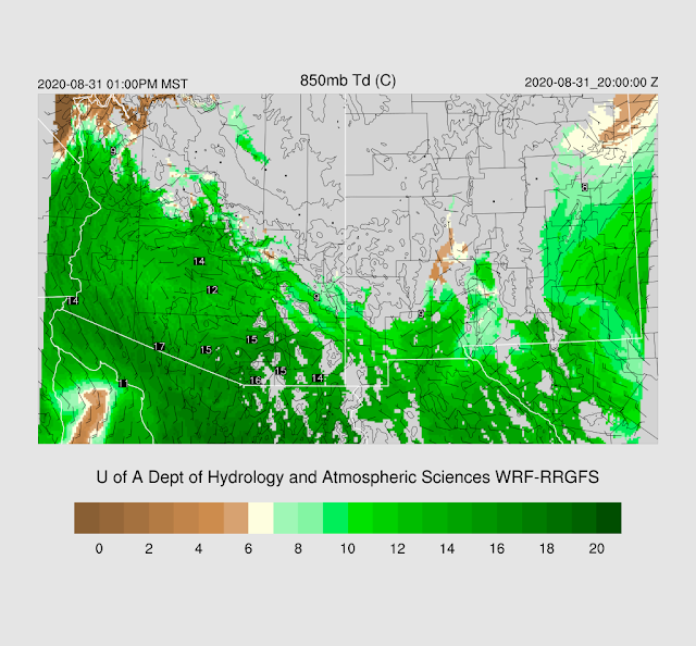
In spite of decreasing PW for much of western Arizona, 850mb dewpoints are still high, indicating the moisture layer is quite shallow.  The high dewpoints are just taunting us.


CAPE is much lower today but is sufficient to support isolated storms over the higher terrain, and perhaps, southeastern Arizona.

The WRFNAM has little or no activity.


The WRFRR is a bit more interesting for southeastern Arizona as it develops some scattered storms by later in the afternoon.  

There is just enough CAPE to support some storms.  Plus, southern Arizona is located under the favorable right entrance region of an upper-level jet streak centered over NM.


The WRFRR continues to redevelop deep convection in this area into the early morning hours.  Both the WRFNAM and WRFGFS get on board by this time too, so maybe this will actually happen.


With the training of echos, the potential is there for a heavy rain event for SE Arizona overnight into the morning hours tomorrow.


Even the HRRR is on board with storms over southern Arizona this afternoon.  However, it has activity as far wast as western Pima County.  I doubt it as that area is probably quite worked over after a couple days of heavy precipitation.  23Z Ensemble Composite.


A strong trough, especially for this time of year, drops rapidly south overnight, into northern Arizona.


A surprising amount of CAPE is ahead of this trough which may result in some early morning activity for this area.  


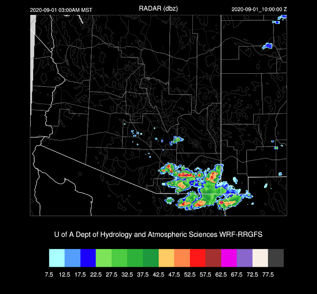
The 15Z WRFRR does develop a few storms strong storms north of Phoenix.


Day 2

The shortwave closed off into a cutoff low over NM.  How strange is that!?


This results in a line of organized convection over western NM during the morning hours, along the cold front.


This passing shortwave also seems to initiate a new surge of moisture into southern Arizona.


 CAPE also increases for much of southern Arizona.


The tail of the front is near the White Mountains by late afternoon which results a few strong storms.  Other activity may form over the higher terrain of southern Arizona where CAPE around 1000-1500 J/kg.


Sunday, August 30, 2020

20200830

 Previous Forecast

It turned out to be an active afternoon and evening over much of the state with much of the activity just west of Tucson.


The model forecasts were a bust for the most part.  One of the reasons was the excessive cloud cover, but even the runs with less cloud cover still didn't have enough activity.  Most of Phoenix except the west side was missed, and Tucson got mostly anvil rain.

It turns out that the Day 2 forecasts from Friday were better, which has typically not been the case this year.
The 15Z WRFRRx was extremely accurate for locations and timing, but a little too intense.  Too bad I discounted all these forecasts!


Discussion
All the activity from last evening has significantly altered the air-mass for parts of southern Arizona.  PW has decreased over southeastern and southcentral Arizona and the soundings exhibit the worked-over "onion" profile.  However, PW continues to increase over western Arizona as Yuma is now over 50mm and Puerto Penasco is 57mm.  Hermosillo was as high as 62mm overnight!
CAPE is minimal for both Tucson and Phoenix so the big question is if the atmosphere can recover enough for afternoon and evening thunderstorms.  The profiles have less warm air in the upper levels which is positive.  Both locations have some speed shear, but not much directional shear.

There is a 50+ knot jet from southern California across northern Arizona and NM which could enhance storms across southern Arizona.  The plot does show some divergence over the area.
The 500mb anticyclone center continues to sink slowly south which results in generally light southwesterly winds over the state.  Quite warm air is present over northern Mexico as a result of the warm-core tropical systems and the high center.    There is still a defined circulation to Iselle, just west of southern Baja.  There is another area of thick clouds and some showers and storms around central Sonora that may be associated with the inverted trough discussed yesterday.  There is no obvious circulation on the 700mb or 500mb map.

Initializations
All the initializations have an inverted trough initialized in the area with extensive clouds and some showers.  Thick clouds stretch to the northeast across southeastern Arizona and these are initialized well.  GFS and RR PW initializations were mostly accurate.  The NAM was somewhat too moist at 12Z, but the correction routine should be able to take care of that.  Overall, the initializations are not too bad considering the complexity.

Day 1
Well, here goes nothing.  Deep southeasterly flow continues to advect very moist air into Arizona, as T.D. Iselle remains mainly stationary.  

PW is very high over much of southern Arizona, so the main threat is very heavy rain/flash flooding.  There is quite a large difference between the 6 and 12Z runs regarding PW for Tucson and Phoenix as 6Z is about 5mm wetter.  I don't think the 6Z initializations were able to correctly predict the drying that occurred after the previous day's activity.  The 6Z WRFGFS is running 12mm wetter at 15Z at Phoenix!

Well, this isn't looking very good.  There is little or no CAPE over southeastern Arizona due to the lack of heating and the morning clouds and showers.  CAPE is also quite low over the higher terrain.  Only southwestern Arizona has CAPE above 1500 J/kg, and it's probably capped.

And it is, at least at Yuma.  The cap isn't quite as strong as I would of thought.

Phoenix doesn't look too bad, but PW is not nearly as high as was being forecast yesterday (~50mm) or even at 6Z.  The inversion at the top of the mixed-layer is weak, so the potential for storms is still there.  The wind profile isn't as good as it was in previous forecasts, but there is still some speed shear.

Tucson recovers somewhat by late afternoon.  The mid-level IT is still located to the south of Tucson resulting in weak easterly flow below 500mb.  Normally, this is good for steering storms from the higher terrain, but areas east of Tucson will have minimal deep convection.


Thunderstorms develop over the higher terrain of Pima County and around Flagstaff and west of there where CAPE is high.

All the runs manage to move/develop storms in and around the Phoenix this evening.  Nothing like the forecasts were saying yesterday, though.

Confidence in any specific details of any model run is very low as the situation is complex, there is a lot of PW, which could trigger deep convection about any time of the day or night, and there is no model consensus.


Not much happens around the Tucson area during the afternoon and evening except for a few isolated storms as the area never recovers after the activity yesterday, partially because of all the clouds around.  However, by the early morning hours, moisture increases and the inverted trough moves towards the area.  CAPE is sufficient to support storms, and it won't take much to trigger deep convection.  PW is high so storms will produce extremely heavy rain.

Both the WRFGFS and NAM develop scattered early morning activity.  

This has the potential to be an extreme rainfall event for somewhere in southern Arizona.


A look at the HRRR is interesting as it keeps the area of thunderstorms near the Sonoran IT going all the way into southern Arizona this afternoon.  It's a possibility, as deep convection continues at 17Z over the coastal areas of Sonora, moving northward.  The HRRR doesn't move the storms into Tucson, of course.  22Z forecast.

Day 2
Iselle continues to remain stationary off the southern Baja resulting in continuous moisture advection into Arizona for another day.  This is quite unusual for 3 days in a row.

PW continues to be very high with 50mm and greater, for much of southwestern Arizona.

CAPE is again moderate to high, and the questions will be how strong is the cap and where/when will it break?  This high moisture, high CAPE environment is proving difficult for WRF to forecast correctly.

Ugh, there is quite a cap during the afternoon hours at Phoenix.

Tucson?  There is only a minimal inversion, but not much CAPE.  The forecast is also dependent on what happens overnight so confidence is very low.

Both the WRFRR and NAM develop intense storms north of Phoenix by late afternoon.

The cap erodes as there appears to be a shortwave that is moving through central Arizona, providing a little synoptic scale lift, and slightly cooler mid-level air.

A lot of things need to come together, so I have my doubts.  If storms can make it into Phoenix, there is a lot of CAPE, so they'll be quite intense.