Previous Day
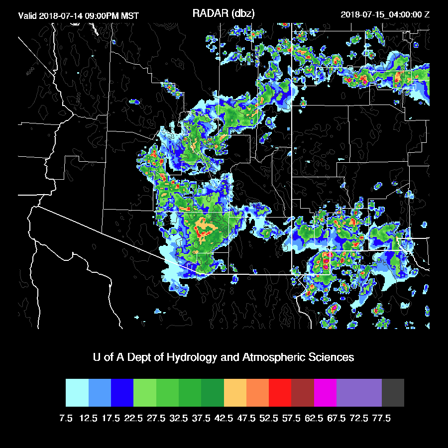
It was active once again from just NW of Phoenix all the way to Vegas and over SE Arizona.
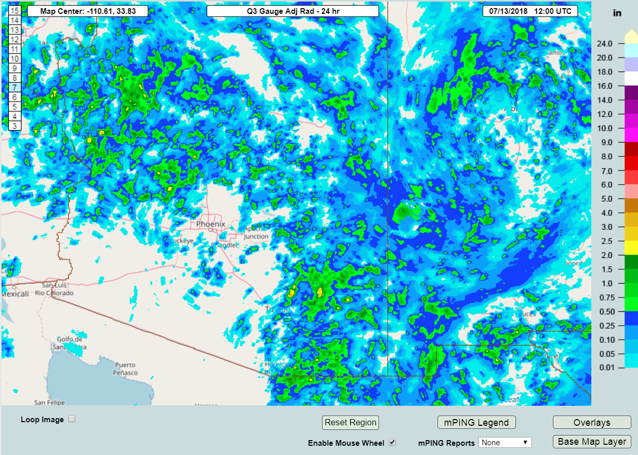
Both the WRFNAM and WRFGFS did not have nearly enough activity over NW Arizona and somewhat too much over far eastern Arizona into NM. I’m not sure why northwestern Arizona busted so bad in those two models and it’s something I need to look at as it was so bad. It may have been too cloudy thus restricting heating. The WRFRR, which I think used the new version of the RR, performed well. It could have had a bit more precipitation over NW Arizona though.

Initializations
A large 500mb ridge dominates the CONUS with one center over Oregon and the other over southeastern MO. Arizona continues to be in mostly light and variable flow and the light NE steering flow over eastern Arizona that was forecast yesterday has not materialized. Satellite imagery does indicate some SW movements of the clouds over eastern Arizona along with a possible weak MCV near Douglas. Maybe it is the same one that was in this area yesterday? The 300mb map has a weak trough over New Mexico which can be seen in the water vapor imagery if you use a little imagination.
Widespread clouds are over the eastern quarter of the state and into western NM and mostly clear elsewhere. The 12Z NAM does not have nearly enough clouds in that area while the RR is better but still not enough either. I checked the 6Z runs and the WRFNAM does have quite a bit of cloud this morning so this run may be better especially for SE Arizona.
Both the 6 and 12Z NAM had a slight wet bias over much of Arizona and into NM while the RR initialized PW well. Overall, either the 6Z WRFNAM or the 12Z WRFRR look to have the better initializations. If the clouds burn off quickly over eastern Arizona, this may negate the lack of clouds in the WRFRR and satellite trends and looking out the window does indicate a general decrease in clouds so far this morning.
Day 1
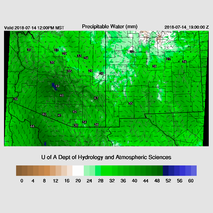
Drying continues to be the story today as it has dried out quite a bit over southwestern Arizona as Organ Pipe has only 35mm of PW. Suominet data indicates slight drying over much of the state the past day but moderate to high amounts of moisture remain over much of eastern Arizona and up into NW Arizona.

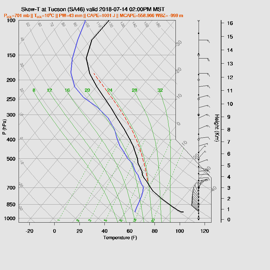
The 12Z upper air data from Tucson has only a minimal amount of MLCAPE but quite a bit of surface based CAPE with heating. By noon, CAPE is moderate to high over SE Arizona thus areas that see heating should again see some storms.

Steering is forecast to become northeasterly at only around 5 to 10 knots but that should be enough to push some storms into lower elevations of SE Arizona.

A few storms form over the higher terrain over eastern Arizona this afternoon.

Moderate CAPE is present in the Tucson area during the late afternoon along with a fairly good wind profile with some mid-level easterly flow and low-level northwesterly flow. Just looking at this, I would say that there should be some activity around later today and into the evening.
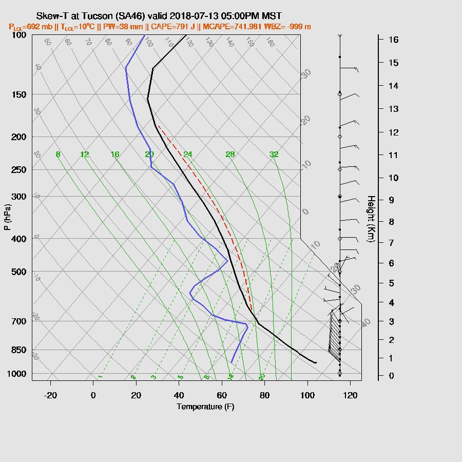
The various runs from the last 6 hours are all a bit different so it’s hard to say what is going to happen in and around Tucson. Most runs keep afternoon and evening storms over the nearby mountains.
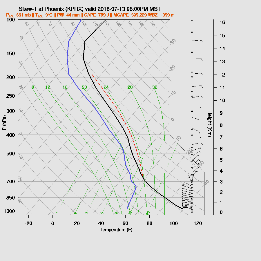
The situation is also a mixed bag for the Phoenix area where CAPE is fairly low but steering/shear are favorable for moving storms towards the valley. Just going by the forecast Skew-T, there might be a storm or two in and around Phoenix in spite of the models not forecasting any activity.
A couple of runs try and develop elevated early morning storms over the lower deserts somewhere around Phoenix to Tucson. If it was just a single run, I’d say it’s unlikely, but a couple runs have them and it appears the storms may be triggered by the incoming outflow/surge from Mexico as discussed below.
Day 2
Both the 12Z WRFGFS and WRFRR develop a large MCS overnight in Sonora which results in a strong outflow driven Gulf Surge into Arizona by morning.

This surge of moisture both increases low-level moisture and provides good low-level westerly inflow to westward propagating storms.
A disadvantage is that this air is quite cool and frequently capped thus deep convection is difficult where the surge is the strongest. However, at the edges, along the Rim and into SE Arizona, CAPE is high thus storms are likely there, initially.

Mid-level steering flow is mainly 5-10 knots from the northeast and maybe it’s strong enough to steer storms towards the deserts. 500mb temperatures are quite warm at around -5 to -4 and with ith the cooling at lower levels, no wonder lower desert CAPE is near 0.

Tucson has between 500 and 1000 J/kg of CAPE during the afternoon hours along with decent shear and some ENE steering flow. Thus it’s possible/likely for some organized deep convection to move into the area later in the day or into the evening.
That is exactly what some of the runs do. The WRFRR moves a broken line of strong storms into the Tucson area by late afternoon or early evening.

Phoenix also has a chance for some storms to move into the valley as the WRFRR (below) does have enough heating to mix the PBL deeply as well as a moderate amount of CAPE. The wind profile is also favorable for storms to move into the lower elevations. The only negative is anvils could out in advance of the storms to reduce heating.

Both the 12Z WRFNAM and WRFRR move deep convection through Phoenix during the evening tomorrow.
No comments:
Post a Comment
Note: Only a member of this blog may post a comment.