Previous Forecast
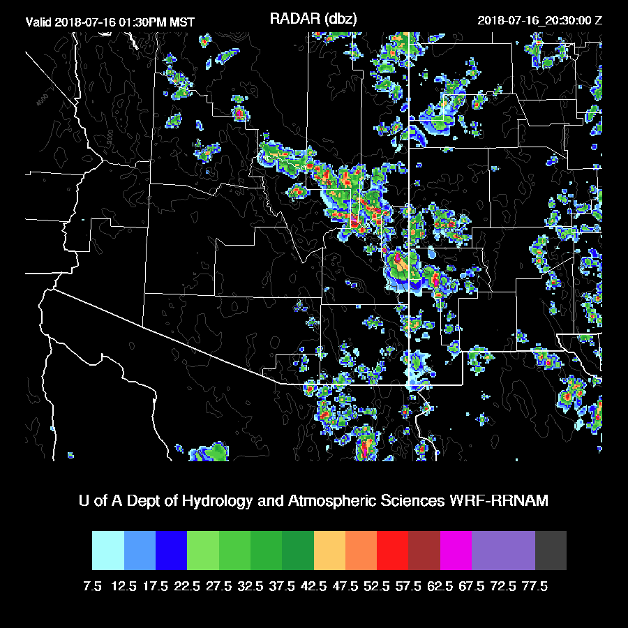
WRF has really been struggling the past few days due to the complex nature of the initializations. The WRFNAM and WRFRR (below) both did an OK job, but both had issues as they developed strong storms during the morning hours around Tucson and Phoenix. In general, the runs have also been struggling to produce enough precipitation over NW Arizona the past few days for some unknown reason.

Initializations
Here we go again. The morning weather situation is again dominated by widespread clouds and a few showers but some clearing is occurring over the eastern ½ of the state. The RR was fairly cloudy over the southwestern ⅓ of the state and did initialize some of the shower activity but in general, didn’t have enough coverage The NAM falsely initialized a strong storm over Yuma county and generally, does not have enough clouds.
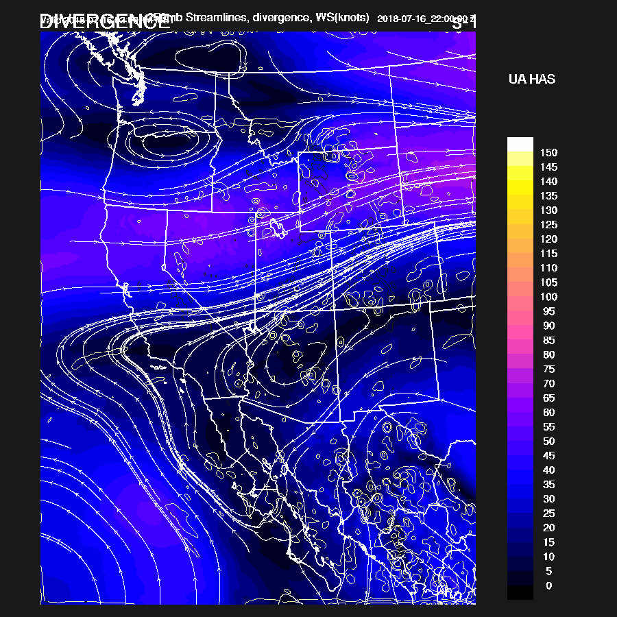
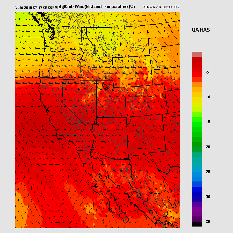
The 500mb map has the ridge centered over southern Nevada and a broad IT over NW Mexico. 500mb temperatures are slightly lower in NM with -6C compared to Arizona at around -5. Water vapor imagery shows a few weak waves moving SW over NM towards Arizona. The RR has the Mexican IT initialized OK as does the NAM.
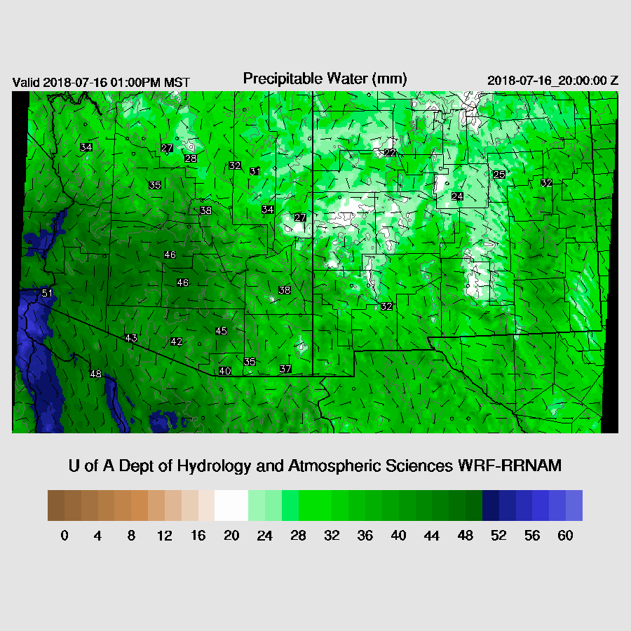
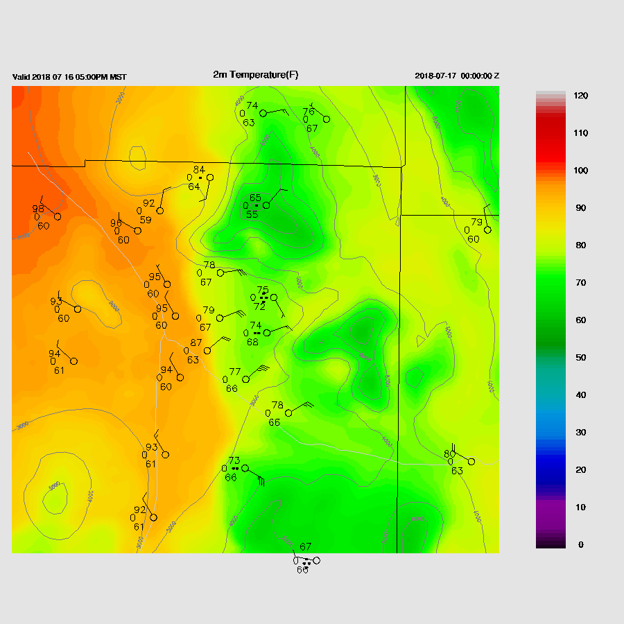
It continues to be very wet over the state with PW again ranging from the low 40’s to over 50mm. Suominet went haywire yesterday with some stations reporting +200mm thus some sanity checks had to be implemented in the correction routine. Data is back to normal today. RR PW initialization errors were small just about everywhere but problems continue with the NAM as large wet errors were present in Mexico and from California to northern New Mexico. Central and southern AZ PW initialization was good. Overall, the WRFRR initialization looks the best and should perform fairly well as all errors are generally small. The 12Z WRFNAM looks quite poor so I took a quick look at 6Z WRFNAM and it had a decent amount of clouds over southern Arizona this morning so may also be useful.
Day 1
Very moist air continues to stream into the state from the Gulf of California and PW continue in the 45-50mm range today. Also, there is a bit of low level westerly flow which should provide a bit of low level shear for storm organization.
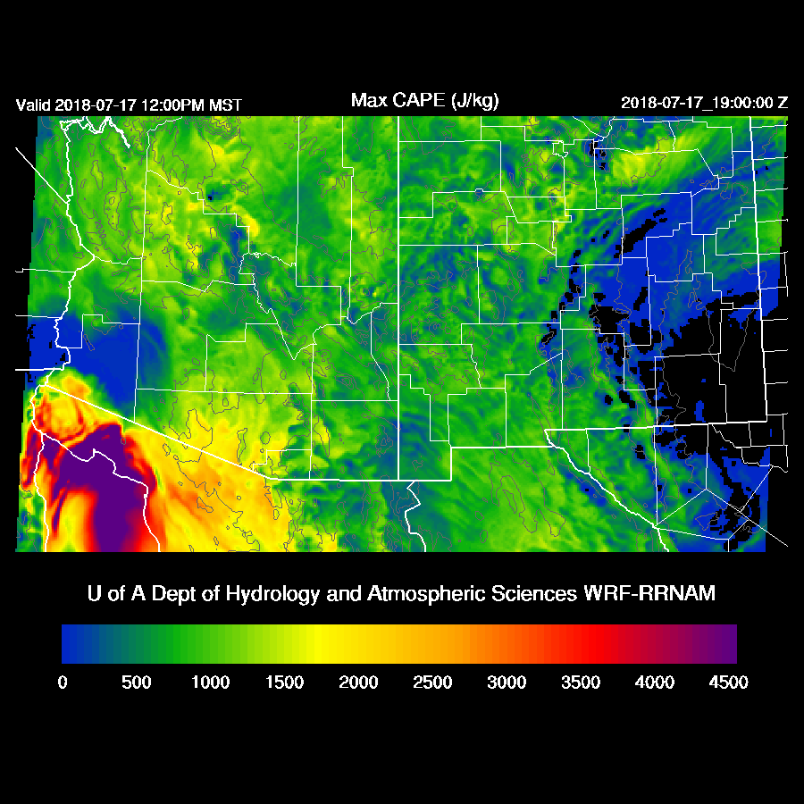
CAPE continues to be minimal over southwestern Arizona due to cooling at the surface and warm air aloft. Areas of SE Arizona have moderate CAPE while the high country has very high CAPE. Storms are likely to be strong with very heavy rain at those locations.

Steering flow is excellent for moving high elevation storms towards the lower deserts. Some slightly cooler air is present in NM which may move into Arizona later and help steepen the lapse rate.

There is also a little upper support as the flow is divergent/difluent over southern Arizona.
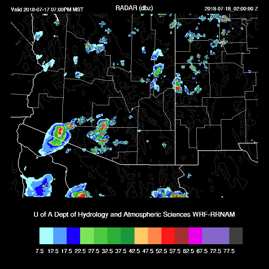
Strong storms initiate by early afternoon over the eastern Rim and White Mountains.
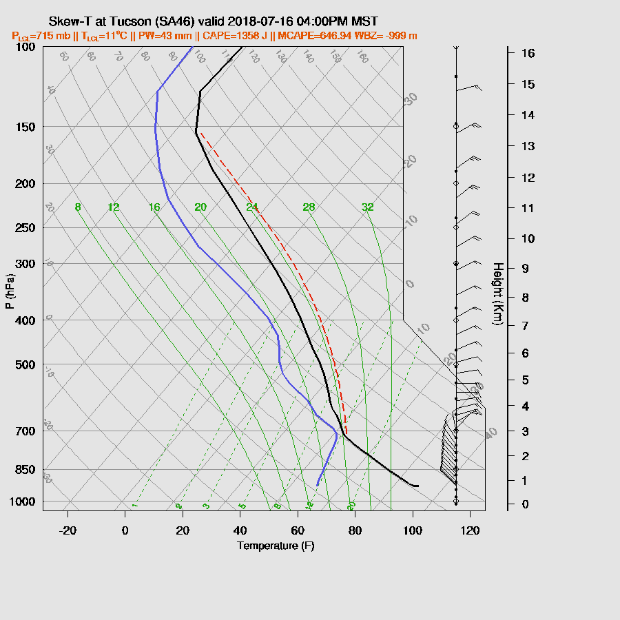
By late afternoon, Tucson has about 600 to 1000 J/kg of CAPE with a deeply mixed PBL and an excellent wind profile. Just based on this, widespread storms are likely.
Strong storms propagate off of the high terrain and are moving into the lower elevations of Maricopa/Pinal/Pima by late afternoon.

Outflow winds aren’t all that strong, around 30-40 knots, as the PBL isn’t that deep but isolated very strong winds are likely due to microbursts.
Storms also move towards the Phoenix area by early evening but the forecast CAPE is too low to support deep convection in the valley proper. The PBL is mixed deeply and the wind profile is good so maybe a few weak storms may pop up as the outflow boundaries move through.

The WRFRR has nothing more than a few showers for the Phoenix area this evening.

Day 2
The 500mb ridge axis stretches from central California over to western New Mexico while a large IT is located over southern Baja resulting in moderate easterly flow across Arizona and unfavorable temperatures around -4C.
Drying is present over all of southern NM and into eastern Arizona. SE Arizona will be especially devoid of deep convection due to downsloping winds. The back door dryline boundary is about over the Tucson area thus just west of Tucson could be where convection initiates tomorrow.

CAPE is moderate to high west of this line especially over far southern Arizona.
Intense deep convection is present in central Pima County and down into Mexico during the afternoon. There are a few strong storms over northwestern Arizona while much of the eastern ½ is quiet as drying continues.

Storms continue over parts of SW Arizona into the evening. Both the WRFNAM and WRFGFS are quite similar so there is some confidence in this forecast.
No comments:
Post a Comment
Note: Only a member of this blog may post a comment.