Previous Forecast
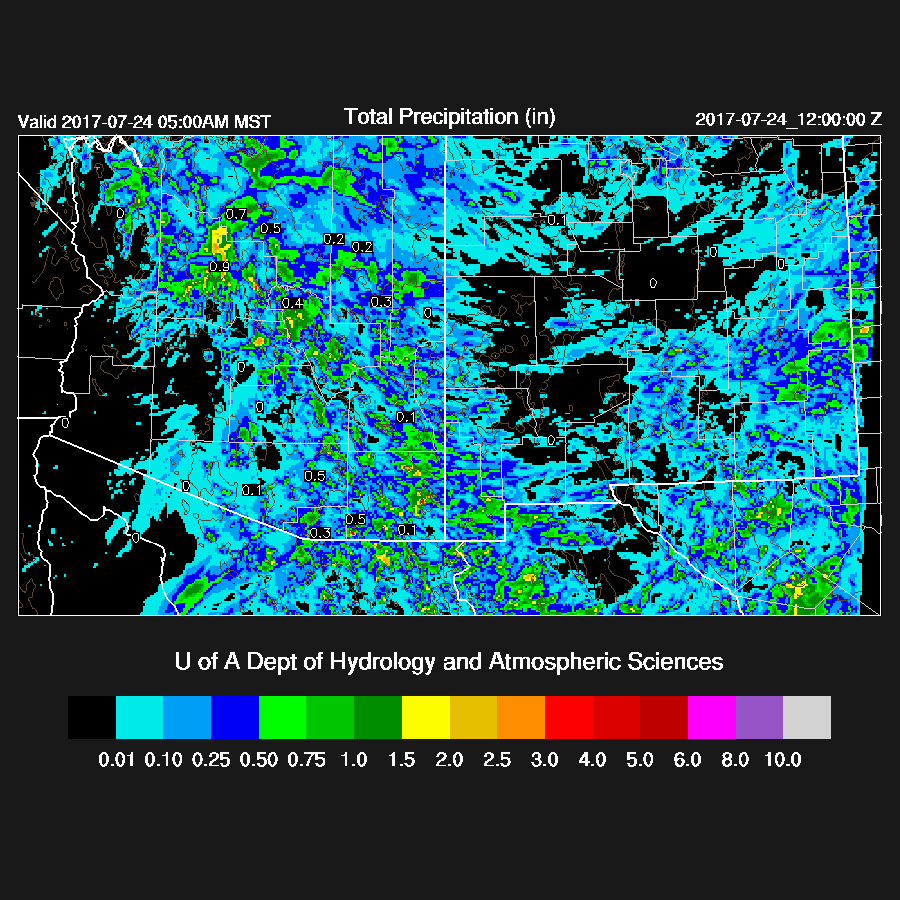
The weather around Arizona was very active as once again, strong storms with very heavy rain occurred from Mohave county down toward SE Arizona. The west side of Tucson received heavy rains as well as parts of eastern Phoenix.


The WRFGFS (below) and the 15Z WRFRRx looked to be the most accurate.
Initializations
The 500mb pattern continues to be about the same as the high center remains to the north of Arizona, a trough off of the west coast, and a weak IT moving over western Arizona. This last feature isn’t really seen very well in the upper air data but is obvious in the RADAR animation. There is no upper air data over all of northern Mexico except for Mazatlan. All the initializations look fine at 500mb.

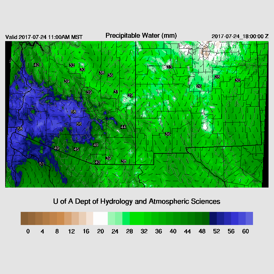
Widespread heavy showers and thunderstorms have developed over central Arizona in response to the northward moving trough and the record setting wet air. Yesterday’s model runs had the convection a bit farther to the SE around Tucson but this error is understandable due to the lack of upper air data upstream in Mexico. Visible satellite imagery does show some clearing in far SE Arizona. The RR initialized the morning activity and clouds very well and the WRFRR even had some clearing over SE Arizona this morning. The NAM initialized the central AZ activity too far to the north and has the southern ⅓ of the state too clear. The GFS is similar as it doesn’t have much morning activity over Pinal and Maricopa counties and it is somewhat too clear over southern Arizona. Now, to the PW. I’m sure this is a record for Phoenix as the most recent IPW is 60.4mm. There has been moisture convergence there all night so no wonder there are widespread showers and storms. Note that the location label on the plot below is incorrect -- the sensor is in Tempe. Two other Arizona sites are reporting over 60mm: Roll (near Yuma) and Buckeye. 
The NAM has a slight wet bias over much of the area while the RR and GFS initialized IPW well. In spite of a complex situation, the RR has initialized well which is what it was designed to do.
Day 1
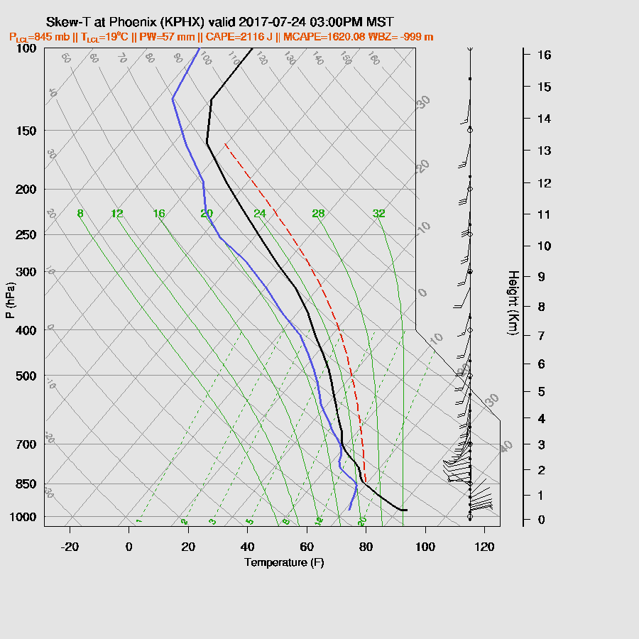
Extremely wet air is present over most of the state today.
However, much drier air is moving into SW Arizona by the afternoon.

Mid-level flow becomes mainly from the SSW during the day as a trough near San Francisco moves slowly to the east. Very warm air at 500mb continues and with weak negative vorticity advection behind the departing trough and as somewhat drier air advects into the state, activity is sure to decrease.

The CAPE forecast has moderate to high CAPE over Maricopa and Pinal Counties by late morning. I find this to be a bit strange as those areas continue to have widespread showers and storms. The WRFRR moves the morning activity to the north and allows some heating by late morning.

Showers and storms move north of Phoenix by late morning and by afternoon, widespread showers and storms are over northern Arizona with a few weak storms over southern Arizona.

Tucson has a moderate amount of CAPE, SE steering flow, and some low level shear thus a few showers and storms are possible this afternoon, mainly near the mountains.

In spite of an enormous amount of moisture and moderate to high CAPE, the afternoon should be mainly quiet in the Phoenix valley as there is a significant inversion on top of the cooled BL and it is unlikely any outflows will enter the valley to trigger deep convection. Winds are also now unfavorable as they are mainly from the SSW.
A few storms continue around SE Arizona during the evening.
A few storms are possible northwest of Phoenix in the early morning hours as a short wave moves through.

Day 2
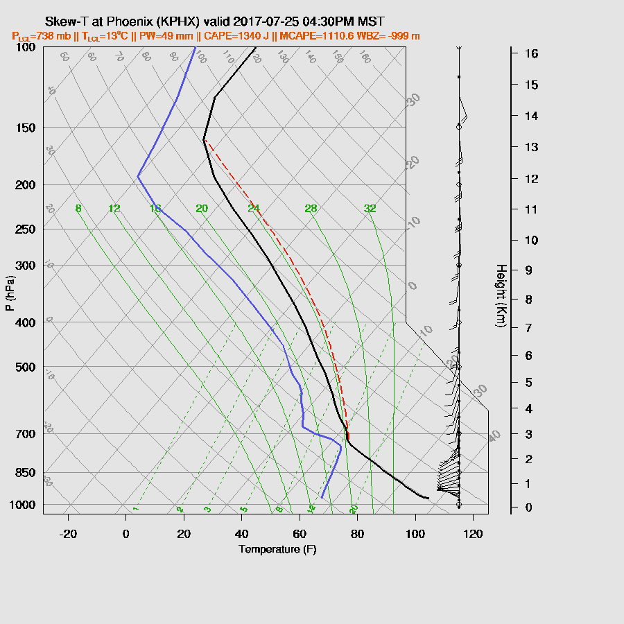
Considerable moisture remains over the state as IPW is nearly 50mm around the Phoenix area. The model runs have a big difference with the amount of drying as the WRFRR is down to 40mm in the Phoenix area. The WRFGFS (below) and the WRFNAM are a bit wetter.

At 850mb much drier air is present over western Arizona. Much of the rest of the state remains very wet.

Moderate to high CAPE continues over much of Arizona so the potential is there for storms. The WRFRR is the odd man out as it has much less CAPE.

Very warm air remains at 500mb with southerly to southwesterly flow over the state. The west coast trough is stationary north of San Francisco.

Drying continues during the afternoon thus CAPE drops to around 4-500 J/kg over Tucson. Winds are mainly unidirectional, from the south which is also not favorable. All the model runs are similar.
.
Phoenix holds on to a bit more CAPE and moisture, but without any outflows, deep convection is unlikely.
Much less activity tomorrow so I probably won’t write a discussion.

No comments:
Post a Comment
Note: Only a member of this blog may post a comment.