Note
This blog is intended for other meteorology professionals (and amateurs!) thus it's technical nature and may not be well understood without a meteorology background.
Previous Forecast
This blog is intended for other meteorology professionals (and amateurs!) thus it's technical nature and may not be well understood without a meteorology background.
Previous Forecast
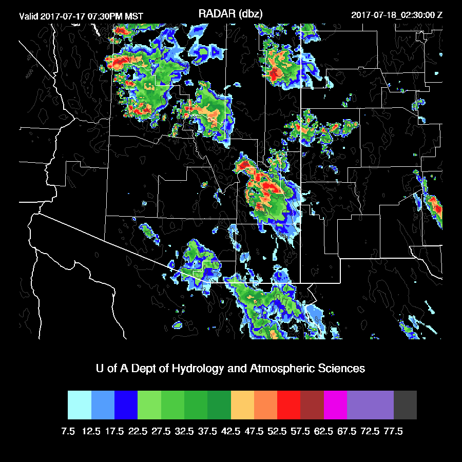
A widespread severe event occurred across central Arizona and into the Phoenix area as an MCS formed over NE Arizona and moved rapidly to the southwest. RADAR indicated a Mesoscale Convective Vortex was present as the MCS moved off of the Rim towards Phoenix. I don’t ever recall seeing an MCV spin up at such high elevations. Here are the Twitter posts here and here. (lightning from weather.graphics)

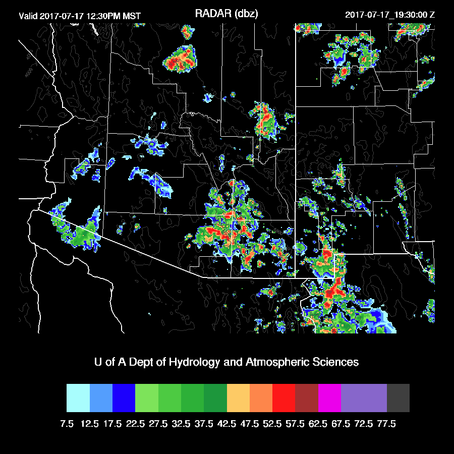
A lot of rain fell yesterday over central and south central Arizona.

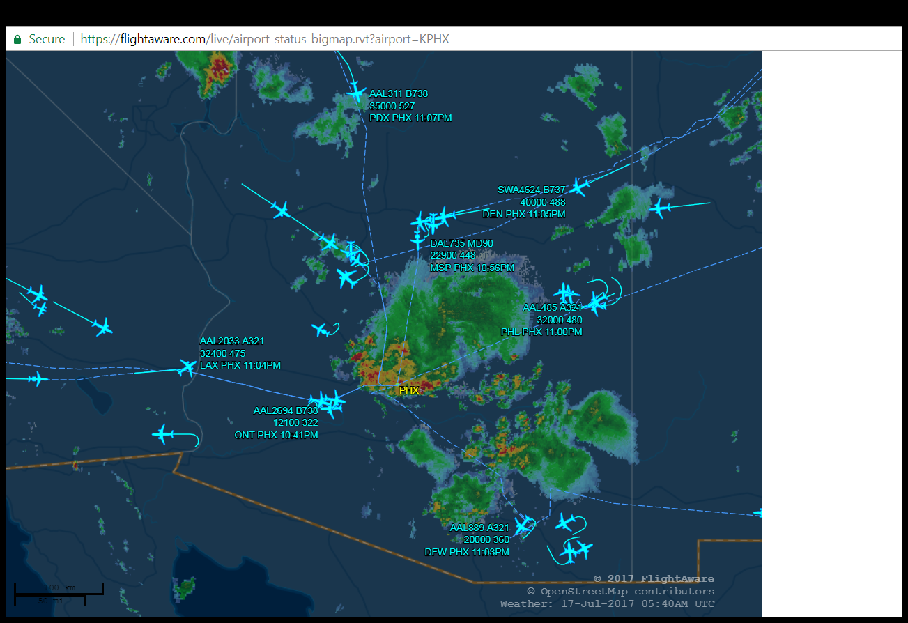
The bad news is that the model runs were mostly wrong as they developed widespread deep convection during the afternoon and moved it into the Phoenix area around 6 pm. In real life, deep convection was scattered and not organized except for some strong storms west of Tucson. The MCS developed over the high terrain of far NE Arizona and as there was little or no afternoon convection to use up the CAPE, the line was able to go all the way to Phoenix and beyond. The 3Z sounding at Phoenix had about 1100 J/kg of CAPE and storms were further enhanced by intersecting outflows that came in from the SE. I don’t really fault the model as this was such an unusual sequence of events and resulted in a rare long lasting and traveling MCS. The impact in Phoenix was significant with flooding, high winds, and the closure of KPHX for about an hour. Below is a plot of the air traffic all in holding patterns. I saw some flights were diverted to Tucson as the holds were so long.
Initializations
The high center has moved to northern Utah putting Arizona in more of an east to ESE flow. Various cyclonic circulations were observed via satellite this morning: a large MCV to the SW of Phoenix, a weak IT over eastern NM and another IT in central Chihuahua. It’s a little hard to tell what is going on over northern Mexico this morning without any upper air data. The NAM does not initialize the MCV as a closed circulation and has it more as an extension of the westward IT that is initialized south of Nogales. The RRx has it as a closed circulation and has also initialized the weak IT in Chihuahua. The GFS initialization of the Arizona MCV is poor as there is only a weak open wave.

Widespread clouds along with some showers and storms are present over much of southern and western Arizona and all of NW Mexico and will present a challenge to the initializations. The WRFNAM, while starting out fairly well, burned of clouds too quickly. The WRFRR and WRFGFS were better and are holding on to clouds this morning, similar to satellite observations. Their 16Z temperatures are also quite close to observed while the WRFNAM is about 5F too high. The NAM is again too wet in NW Mexico and into New Mexico. The RR and GFS have only minimal errors. From what I’ve seen so far, the WRFRRx has the best initialization. However, as the situation is so complex and there was so much activity yesterday, model confidence is low.
Day 1
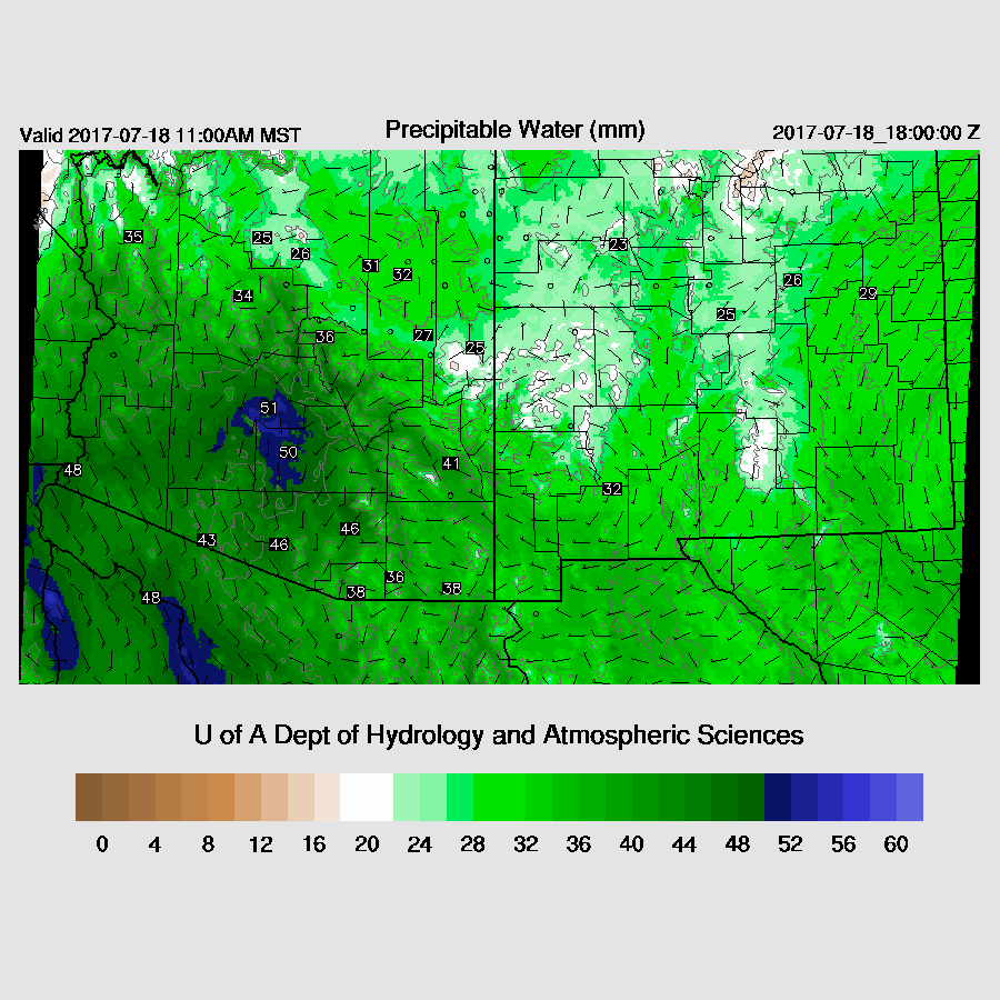
Very wet air continues over almost all of the state. In fact, one has to go nearly all the way to Puerto Vallarta to find wetter air.

At 850mb, SE Arizona dewpoint temperatures are very high, above 15C, thus there is a risk of very heavy precipitation in this area and it is likely to be the more active area due to some heating and the proximity of the MCV. Many times, convection forms near the cloud edges of old MCVs.

The MCV moves slowly to the SW during the morning and with the 500 mb high center repositioning, steering flow becomes southeasterly which is more favorable for SE Arizona. However, the 500 mb air is quite warm with temperatures again around -4 to -5C.

That doesn’t seem to impact CAPE much as it is high over SE Arizona, above 1500 J/kg most places. With some heating, this area should be quite active.

Showers and thunderstorms get an early start over SE Arizona as there is even activity in Tucson by noon. The morning 12Z Tucson sounding was near saturation all the way up with an MLCAPE of around 600 J/kg. Not great, but enough to support storms and with the tropical look and feel, very heavy rain is possible. By late morning, CAPE is forecast to increase to around 1300 J/kg, which is more than enough. There is some moderate SE steering flow so storms should be able to move of of the higher terrain into the valleys. However, it is certainly possible that it is ‘too wet to rain’ in Tucson, meaning mountain storms fire off early because it is so wet and unstable, then send out clouds over the valleys which cut off heating and send out cooling outflows stabilizing the atmosphere.

Storms develop before noon over SE Arizona and a few manage to form just afternoon in the Tucson area. Expect very heavy rain and isolated high winds with wet microbursts.
Storms continue around SE Arizona into the late afternoon. A few storms get going over the high terrain by this time too.

Phoenix, while having decent CAPE, is quite capped. Plus steering winds are weak thus any storms that form over higher terrain are unlikely to move much.

However, the WRFGFS has a much different looking vertical profile as mid-level steering winds are much stronger and the BL is mixed deeper with less of an inversion. This looks more favorable for deep convection near and maybe in parts of Phoenix. The rule of thumb is that after an active day, the next day has minimal activity. I find this solution less likely, but can’t rule it out.

Storm activity continues over the higher terrain around Phoenix into the evening. All model runs are a bit different on the location and timing of storms.
The WRFGFS (below) moves some strong storms into eastern Maricopa County this evening and weakens them as they move into the lower elevations of Phoenix.

It looks possible for another round of overnight showers or storms in the Tucson area and maybe even a ‘morning surprise’ when heavy rain can occur around sunrise. With an IPW of 52mm, anything can happen about any time.


Day 2
Confidence will be low for the Day 2 forecast due to the high level of uncertainty in Day 1. Moderate SE 500mb flow continues with weak inverted troughs passing through. One appears to be just to the south of Nogales tomorrow.

CAPE varies substantially between the runs with almost nothing to a lot and it’s not possible to tell which is best. One certainty is continued very wet air present over much of the state.
Storms really don’t get going until later in the afternoon and die before they can make it into the lower deserts.
No comments:
Post a Comment
Note: Only a member of this blog may post a comment.