Previous Forecast
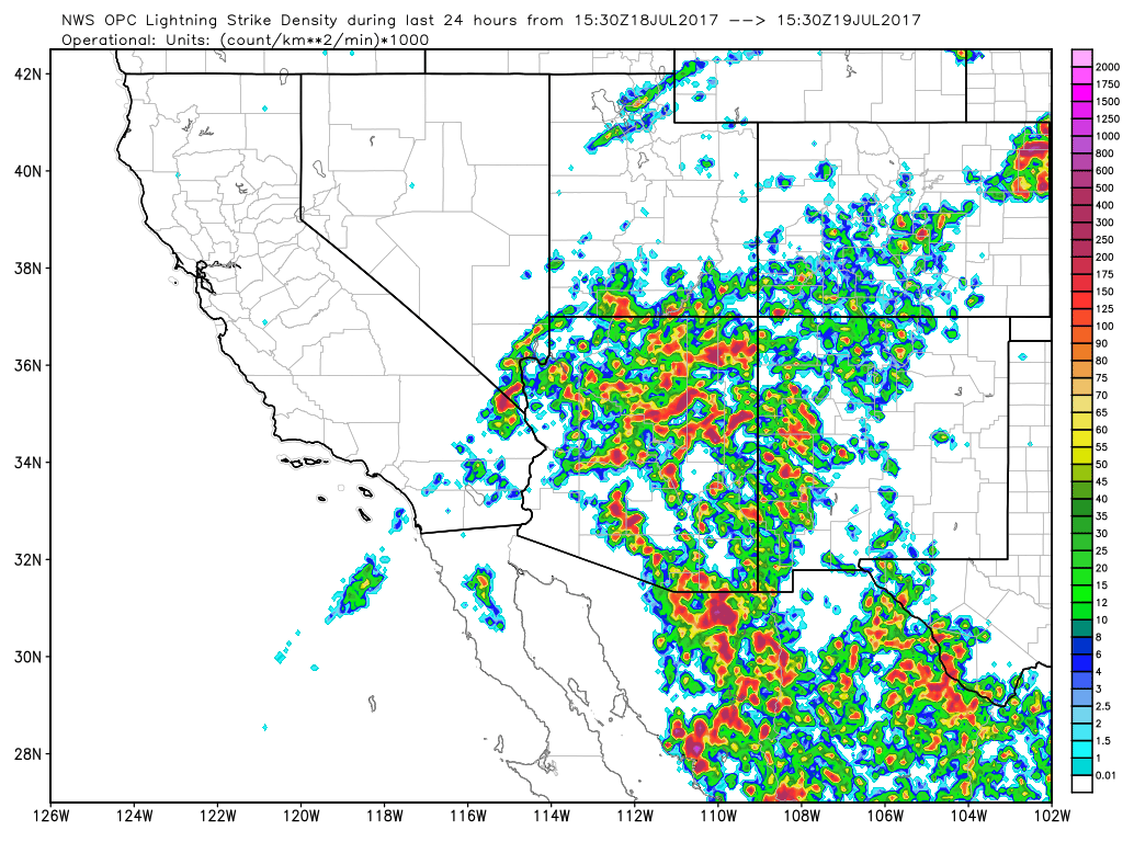
It was a very active day about everywhere except around Tucson and Phoenix and in far SW Arizona.
As discussed yesterday, model agreement was poor and I was unable to sort out which would be the most accurate. It turns out that none of the runs were much good as they all had some major failings. Let’s move on.
Initializations
Bad news as the cluster crashed last night thus delaying all the runs. As of 16:30Z, the WRFRR is the only model available. Just going on that, it’s probably going to be a big day in either Tucson or Phoenix!
The 500mb high center has shifted eastward away from the western CONUS thus putting much of the state in SE flow of 15 to 20 knots. This should allow some storms to move off higher terrain into the lower elevations, especially around Tucson. A large 300-200mb TUTT is moving NW and is centered over El Paso. Much drier air at the mid and high levels is just moving into far eastern Arizona and this may have some negative impact on storms there today. Other than that, I’m not really sure how these can impact Arizona. Maybe Bob Maddox can comment.

Satellite imagery indicates an MCV SW of Nogales, another in far southern Sonora, and a third, south of Las Vegas. The RRx initialization has the southern Sonora and Vegas IT. It also has a large area of weak cyclonic flow over much of NW Mexico, but that is difficult to verify as there continues to be no data from NW Mexico. Even the La Paz upper air data is missing this morning. It’s mostly clear across much of Arizona except for SW and far western Arizona in the vicinity of the various MCVs. I’ll be looking at the 6Z WRFNAM also this morning. It’s 500mb was similar to the RR as it did have the larger MCVs initialized OK and it also has fairly good morning cloud coverage. The RR clouds are also fairly well initialized and even somewhat too much coverage. IPW initialization for both runs is mostly good with only minor errors. Some of the missing NW Mexico IPW sensors have returned. Overall, the two runs look fairly good and either one should perform OK today. Day 2 confidence is low mainly due to all the uncertainty in NW Mexico.
Day 1
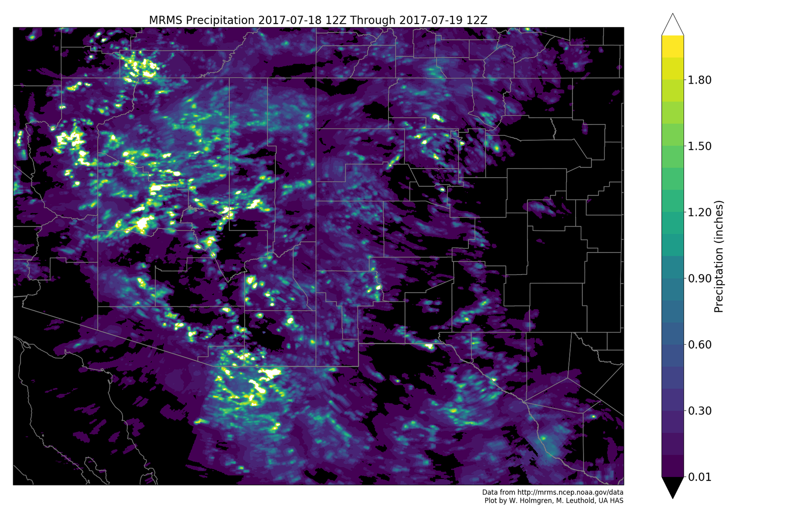
Very wet air continues over most of the state except for the far east where strong subsidence is occurring in advance of the TUTT and over far SW Arizona where drier air is advecting in at around 850mb as was discussed yesterday. In between these areas should be quite active today.

Upper flow over Arizona is weakly difluent and divergent thus some upper support for storms.

SE flow continues over much of the southern ½ of the state which will result in some steering of storms off of the higher terrain. Slightly cooler air is also moving into SE Arizona so perhaps that will be the most active area today.

Low to moderate CAPE is mainly over the eastern ⅓ of the state. The two runs are much different as the 6Z WRFNAM has much more CAPE over north central Arizona as it’s wetter and warmer, which is incorrect.

By afternoon, scattered storms develop over most of the higher terrain of eastern Arizona.

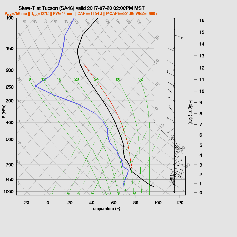
The Tucson forecast profile for the early afternoon has a moderate amount of CAPE, good SE steering flow, and a well-mixed PBL with a weak inversion on top of the PBL. As yesterday, upper flow is mostly unidirectional thus anvil shading (as Bob Maddox mentioned yesterday) may again be a problem for the Tucson area.

The WRFRR does not move storms into the Tucson valley but there still may be one or two that form anyway. Scattered storms continue around the eastern part of the state into the late afternoon.

Phoenix has a bit of CAPE this evening, but probably not enough to support any storms.

Some storms may be present east of Phoenix this evening. The WRFRR only went out to 2Z so I can’t say what happens later. Looking at the 6Z WRFNAM, it is more active tonight from Phoenix eastward.

Day 2
This forecast is based on the 6z runs. 500mb flow weakens and becomes light and variable for most of the state thus storms will mainly remain over the higher terrain.

Very wet air remains over central and eastern Arizona thus storms are again likely over higher terrain of those areas and will produce very heavy rains.

The slight drying trend over far NW Mexico is over as very wet air moves back in due to a weak surge. Very wet air is present over much of the Gulf of California. A plume of wet air is advected into Utah in advance of a west coast trough.

Tucson continues to have decent afternoon CAPE, wet air, and good heating. Low/mid level winds are poor, but upper flow becomes northwesterly as the TUTT is in NM and the west coast trough suppresses the 250mb high into Mexico. Too bad there wasn’t some steering from the east or southeast so that anvils would propagate away from storm motion. In any case, storms around the Tucson valley with maybe a few at low elevations.
Looks like the same situation in Phoenix. Storms around the valley over the higher elevations.

No comments:
Post a Comment
Note: Only a member of this blog may post a comment.