Previous Forecast
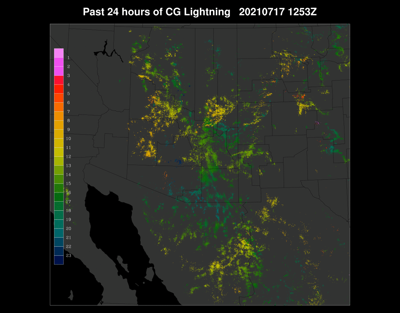
It was an active day for many parts of the state due to an inverted trough and copious amounts of moisture. There were many areas of heavy rain with Q3 estimates over 3" in some areas.
As mentioned yesterday, it was a complicated situation, and many of the initializations were not very accurate. No run performed well, but the various WRFRR runs had a general idea. They had heavy precipitation in Yavapai County and some of the heavy precipitation in eastern and southeastern Arizona. They missed the heavy precipitation in Graham County. No run was able to predict the activity in western/southern Maricopa County last evening. The 15Z WRFRR was the only one close as it had a few storms there after sunset, but nothing remotely close to the widespread activity that occurred.
The HRRR from yesterday did a fair job, and subjectively, better than the WRF, for most areas. It was able to predict the scattered activity around Phoenix last night, but it also way too much activity in Tucson, where there was none.
Discussion
As much of the state received significant precipitation, today will likely have much less in those areas. The 500mb map finally looks like a "typical" monsoon pattern with a not too strong anticyclone located somewhere from Elpso up to the Four Corners, resulting in generally southeasterly flow over the state. Temperatures are also reasonable at -6 to -7C. It's not visible here, but a 700mb inverted trough moves across the state, with what appears to be an MCV embedded, centered over Phoenix.
Both the Tucson and Phoenix Skew-T have a worked-over green onion appearance, but Tucson still manages 760 J/kg of MLCAPE, so with some sun, storms are a possibility. Winds are generally SE to NE and around 10 knots, which isn't great but better than light and variable. Storms that do form won't move very fast, and with the moist air mass, flash flooding is likely.
InitializationsWhile not as complicated as yesterday, it's still going to be a challenge to get the initialization accurate due to the widespread clouds in the vicinity of the MCV. At least there are no ongoing thunderstorms. GOES PW indicates nearly 50mm over southwestern Arizona and widespread areas in the 30mm range. No initialization had the closed ~700mb circulation of the suspected MCV, but they all had a sharp IT in the general area. Good enough. Cloud cover was initialized well by the 6Z GFS and all of the RR initializations. PW was initialized well by all the RR initializations. 6Z GFS was OK, and the NAM was poor. The RR and GFS initializations are generally good, and the WRF should perform well. Finally, a day where model confidence is high.
The Gulf Surge has finally weakened, but not before advecting 50mm of PW into western and central Arizona. The rest of the state is also very moist, with even the high elevations having over 24mm.
It goes without saying that the flash flooding risk is high today. 850mb dew points are high with 14-16C in some areas. These are about as high as they get for Arizona, outside of a tropical system.
The CAPE forecast has some isolated areas of moderate to high CAPE, but generally, it's quite low due to the worked over nature of the air mass over the state. That's not to say that it will be a down day everywhere as there will be plenty of heating over much of eastern Arizona, and CAPE should increase throughout the day. It does look like the hotspot will be parts of Pima County. Eastern NM is another hotspot as CAPE is extremely high.
By mid-afternoon, thunderstorms, some with heavy rain, are underway in the more favorable CAPE regions. Most of the model runs are similar with the timing and locations. Finally, there is some consistency between the runs.
The Tucson Skew-T forecast looks quite good by late afternoon with a moderate CAPE and a fairly well mixed PBL. Winds are also orientated to steer storms from the higher terrain of Santa Cruz and Cochise Counties into the area. The one problem is that mid and upper winds are unidirectional. Thus, anvils are likely to blow out in advance of the storms.
Recent model runs are split on moving the activity into Tucson. The middle of the road is the 15Z WRFRR which moves a few storms into the Tucson area by late afternoon. An organized line of storms marches across northwestern Arizona.
Storms continue over far southeastern Arizona into the evening. Again, all runs are very similar, so confidence is high. The storms in NW Arizona decrease as they approach the Colorado River. The rest of the state is mostly quiet.
The potential is there for Phoenix, but some kind of OFBs will be needed to trigger deep convection, which looks unlikely.
Activity generally wains after midnight. There remains a slight chance that there could be a few storms around the Tucson-Phoenix area late, as CAPE is around 1000 J/kg.
The WRFNAM obviously had issues around the Phoenix area. It erroneously developed storms there this morning. I don't even know why I bother running it anymore, as it's almost always the worst performing run.

Day 2
The advection of moisture due to the Surge is mostly over, but more than enough remains over the state for continued activity. The air mass just south of Arizona remains extremely moist, and there is a tropical system starting to approach the southern Baja. The official track keeps it south of there but could eventually be close enough to trigger another Gulf Surge.
Southeastern Arizona looks a bit worked over as there is minimal CAPE. Other areas look pretty good, especially NW Arizona.
Most runs do have NW Arizona quite active by late in the afternoon.
Both Tucson and Phoenix have weak caps to overcome, requiring some sort of OFB interactions. So far, that doesn't look likely to occur. CAPE is especially impressive at Tucson by late afternoon.
Only the WRFGFS develops storms for Tucson.


No comments:
Post a Comment
Note: Only a member of this blog may post a comment.