Previous Forecast
Storms tried to make it into the lower deserts but fizzled.

All of the runs were too optimistic about moving higher elevation storms into the low deserts.

Discussion
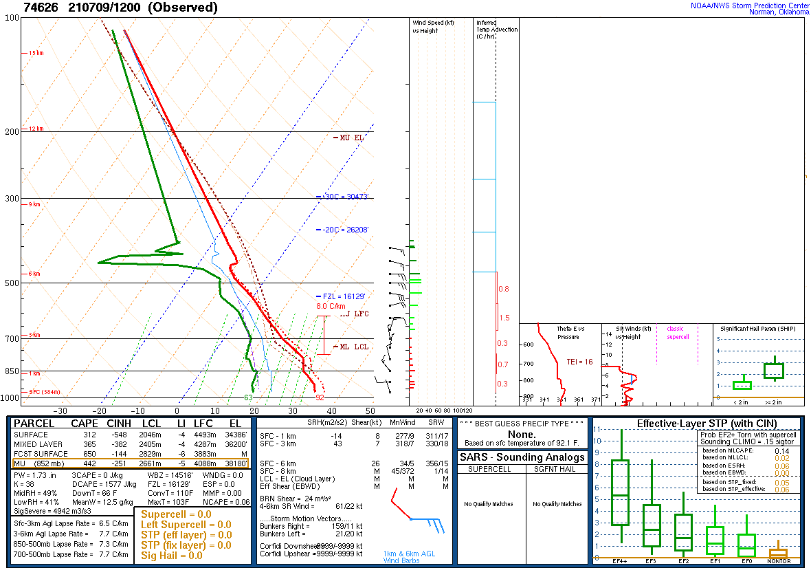
Yesterday's forecast was for a big increase in CAPE, and that did somewhat verify as Tucson has 1500 J/kg. It's not like the 3000 J/kg that was forecast, though, and perhaps this may be the reason there wasn't more overnight activity. There is a weak inversion on top of the moist layer and another stronger subsistence inversion above 500mb. There is enough CAPE and heating to overcome these inversions, so some deep convection is possible in and around Tucson based on the Skew-T.

The CAPE and moisture forecast didn't work out for Phoenix as CAPE is only a few hundred J/kg. What did work out is the significant cooling of the lowest layers resulting in an inversion around 850mb.
Since yesterday, the 500mb anticyclone has strengthened and continues to be centered along the AZ/UT border. Strong easterly flow is present from southern Arizona to southern California. Too much easterly flow can be a bad thing as storms can be sheared apart, and/or it can help organize and move storms fairly rapidly. Temperatures are not very favorable at -4 to -6C.

GOES CAPE is interesting as it shows a large area of ~500 J/kg that stretches from Pima County up towards Prescott. I overlaid SPC CAPE as a comparison as I'm always interested to see how the 2 compare as they are frequently different. In this case, GOES CAPE doesn't seem to be nearly as high as it should be, as the Tucson sounding had 1500 J/kg, as does the analysis.

Initializations
As seen above, skies are mostly clear across the state, initialized correctly by all runs. PW errors are minimal, except for the NAM. It is too moist for southern Arizona and NM but not too bad elsewhere. There were no cyclonic circulations noted either from the upper-air data or satellite imagery. The RR and GFS are the favored initializations.
Day 1
Is today going to live up to some of the hype from yesterday? As mentioned earlier, CAPE/moisture isn't as high as was forecast, but there should be enough for some activity later. The moist air is slowly winning the battle as it pushes the dryline slowly to the east today. However, higher elevations, the source for convective initiation, are still dry. It's interesting to see how the moisture is dammed up against the Rim.

CAPE is certainly high along this backdoor dryline. Perhaps deep convection can initiate along the line and/or the higher terrain of Gila County.


There seems to be just enough CAPE to keep these storms alive as they move to the SW over the Plateau. Storms strengthen as they move into the more favorable CAPE.

What is interesting to me is that every run over the past 24 hours has pretty much the same forecast. Below is the 0Z WRFGFS.

The forecast Skew-T for Phoenix looks good by early evening as CAPE is around 1600 J/kg, excellent wind profile including low-level shear and mid-level steering. The mixed layer is fairly deep with only a minimal inversion. Note the significant inverted V profile, which is favorable for strong winds. The morning sounding backs this up as it had 1500 J/kg DCAPE.

Tucson looks pretty good, too, with around 500-1000 J/kg of CAPE.

Most runs move these storms into the lower elevations of south-central Arizona during the late evening hours.

A few runs keep the storms going all the way into western Arizona and may generate a haboob.


The 12Z runs aren't quite as active, and storms weaken. Note that none of the model runs have storms in either the Phoenix or Tucson metro areas. It still could happen as the forecast Skew-Ts for both Tucson and Phoenix don't rule it out.


What the!? The 15Z WRFRR is devoid of late evening activity! The runs all were consistent with this activity up until this run.

Day 2
Moisture is plentiful as a surge continues to advect moist air into all of southern Arizona. In fact, monsoon moisture has managed to make it all the way to central California.

The 500mb anticyclone shifts slightly to the west and is located over Vegas, resulting in a favorable northeasterly steering flow. Temperatures aren't very good, with mainly -5 to -6C.

CAPE is excellent for much of southeastern Arizona, and with plenty of heating, it should be an active day.

Large storms are scattered about southeastern Arizona by late afternoon.

Tucson looks good for activity as there is a lot of low-level shear, good steering, and more than 1000 J/kg of CAPE.

Phoenix has a significant inversion at the top of the mixed layer, which keeps activity limited despite 1-2000 J/kg of CAPE and a good wind profile. It will take multiple OBF intersections to get deep convection to go there, which looks unlikely.

Activity is quite widespread and intense over southeastern Arizona during the evening hours.

Thunderstorm winds are expected to be severe. Some runs have winds over 50 knots so gusts over 70 knots are possible.

No comments:
Post a Comment
Note: Only a member of this blog may post a comment.