Tuesday, August 31, 2021

20210831

Previous Forecast

Some locations of western Arizona got hammered with up to 4" of rain, according to Q3 estimates.  A few weak storms moved through Tucson during the late afternoon/early evening.  Early morning activity developed over western Pima/southern Maricopa, also producing heavy rain.

The model forecasts were generally accurate on locations but way too low on precipitation amounts.  They all missed the heavy precipitation in La Paz County.


Discussion

The 500mb map has the anticyclone centered somewhere over northern NM resulting in a favorable southeasterly flow.   A broad IT is located over far NW Mexico with two shortwave/MCVs near Vegas and SW of Phoenix.  There is a residual low-level circulation left from Nora, just off the coast of Sinaloa.  Thunderstorms are underway offshore, and maybe it will regenerate a little.

The 300mb map has the upper low moving slowly towards the state resulting in strong upper divergence.  This is obviously helping the ongoing activity in SW Arizona and around Puerto Penasco, where strong storms are underway.

The Yuma sounding had 50mm of PW, but the lower troposphere was somewhat worked over, probably from the earlier activity.  There was 1150 J/kg of CAPE, but it is elevated at 750mb.  Tucson isn't any better as there is only 360 J/kg of MLCAPE.  The wind profile is taking on a transition-type look with veering winds.  There isn't enough directional or speed shear for supercells, but enough for some storm organization.
Phoenix looks about the same as Tucson, with minimal MLCAPE.  Both are saturated above 700mb, and with such a wet atmosphere, any CAPE is probably enough for storms, especially with the upper divergence.
Initializations
It's going to be a challenge to get a decent initialization today, for sure.  Clouds are quite thick this morning, but satellite trends show a gradual decrease.  The 6Z GFS did a reasonable job with both clouds, storms, and the various inverted troughs.  The 9Z RR was missing the far NW Sonora activity, probably due to not having much of a cyclonic circulation initialized there.  Other than that, it was OK.  The 12Z RR also lacks the storms and associated MCV but did have an IT located near Puerto Penasco.  It has too much activity west of Phoenix.  The 12Z NAM did manage to initialize storms and associated weak MCV, but the storms were a bit too far north.  It managed to initialized clouds OK.  Suominet is still having issues with missing stations, but there are some available in Arizona.  There are minimal errors at these sites, including the NAM. The end result is there is no good initialization, but none of them are terrible.  

Day 1
The one certainty for today is that there will be plenty of moisture!  The issues are how much heating there will be as well as the impact of the approaching trough.

CAPE is forecast to be moderate to high over much of southwestern and southcentral Arizona this afternoon.  It's low elsewhere, but as mentioned earlier, sufficient for storms, just about anywhere due to the support of the upper trough.


The early afternoon Skew-T diagram indicates CAPE has increased at Tucson, with over 1300 J/kg.  The wind profile also looks good, with low-level shear and quite strong easterly steering flow.  What is even more interesting is the wind profile now has a decent amount of directional shear. Thus storms are likely to be organized, with the potential of some mini-supercells.

As would be expected, the various runs vary widely on the details. Still, generally, most develop showers and strong to severe storms by the early afternoon over southwestern and far south-central Arizona. 

In areas that get some sun,  from satellite imagery are eastern/central Pima, Pinal, and eastern Maricopa Counties, big storms are expected by later in the afternoon.

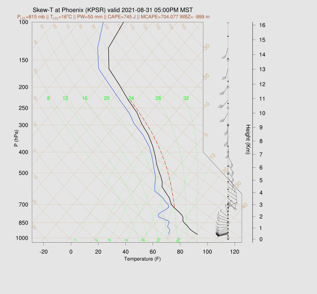
Despite 50mm of PW (or more), Phoenix only manages ~700 J/kg of CAPE.  The wind profile is good with low-level shear and mid-level directional shear.  At least in this run, there is a cap on top of the multiple shallow mixed layers, which may keep deep convection from forming.

Yesterday, it looked like southeastern Arizona wouldn't see too much activity, but today's runs tell a different story.  Most develop widespread activity this evening.

The main threat today/tonight is very heavy rain and flash flooding.  A few storms could produce isolated severe winds due to wet microbursts.  The four-panel QPF has the heaviest rains over south-central and southeastern Arizona.  Many runs have a few areas over 3", and maybe as much as 6"!  

Rain and some thunderstorms continue into the early morning hours for much of the eastern 1/2 of the state. 


Day 2
The California trough starts to move into Arizona during the morning hours, with continued upper divergence providing support for deep convection.  (12Z tomorrow)

It appears there will be another round of storms for southern Arizona as Tucson manages to recover somewhat as CAPE is around 800 J/kg.  The atmosphere is saturated below 400mb so, any precipitation is likely to be very heavy.


Many runs develop scattered storms over southern Arizona during the morning hours.

Activity moves east during the afternoon hours.

Parts of eastern Pima County could see an enormous amount of rain.  Many of the 48h 4-panel plots have some areas receiving more than 4" of rain, with the outlier WRFRR run with some 8" amounts!  This has the potential to be a major flash flood event.

The 15Z WRFRR QPF is similar to many of the earlier runs with widespread 1" amounts and isolated amounts around 6".


As the upper trough passes through Arizona, temperatures increase significantly above 500mb.  Moisture also decreases, but it's still quite wet below the inversion.  Phoenix manages 1100 J/kg by late afternoon, thus there is still some potential for a few storms.

Some of the WRFRR runs do develop some storms for the Phoenix area during the evening hours.


Monday, August 30, 2021

20210830

 Previous Forecast(Aug 29)

Storms were scattered across southern Arizona as well as Tucson.  There were multiple severe, warned storms within the Tucson valley.  WRF runs were generally pretty good.  The WRFGFS underpredicted precipitation amounts, though.


Discussion
It turns out the GFS track for Nora was the most accurate as it moved it more to the east, keeping it over land, which resulted in rapid weakening.  This morning, nothing is left of the circulation, and it was declared dead.  Satellite imagery indicates a broad area of weak cyclonic motion over much of NW Mexico.  The 500mb ridge axis is located from California into west Texas, resulting in a southeasterly steering flow.  Temperatures are fairly cool, at about -7 to -8C.  There is a cut-off low at the upper levels off the southern California coast, providing SSW flow and perhaps some upper divergence over the state.


The morning soundings aren't very interesting as CAPE is minimal.  The mid-levels are saturated, resulting in widespread clouds over the state.

Initializations
All have the remnants of Nora initialized over Sinaloa, which looks accurate using satellite imagery.  Widespread clouds are cover all of NW Mexico and parts of Arizona.  The GFS and RR did a good job initializing them.  Suominet is down this morning, so no PW checks can be done.  Even though the situation is complex, the GFS and RR did well with the initial conditions.

Day 1
A weak gulf surge is underway in southwestern Arizona as dewpoints are in the mid to up 70's.  It's not possible to tell how deep it is without Suominet or sounding data.  The surge continues into the afternoon, resulting in a slow increase in moisture.  Moderate easterly flow is present over eastern Arizona, advecting slightly drier air into that area.  Again, there is a low-level convergence line north and south of a line through eastern Pima County.  As mentioned before, sometimes this can act as an initiation point and also enhance deep convection.

850mb Td gives a better idea of what is going on as it shows that the surge is quite shallow over southwestern Arizona as it's quite dry and has light and variable winds.  The more favorable dew points are over south-central Arizona, while southeastern Arizona is in unfavorable easterly downslope conditions.  I'd say the outlined area is the most favorable for deep convection later today.

CAPE is low to moderate over much of the state, so storms could form just about anywhere over the higher terrain.

Storms develop from around Tucson to the west by later in the afternoon.  The Rim/White Mountains also become quite active, as well as NW Arizona, where CAPE is more favorable.

CAPE is marginal at Tucson with only 4-600 J/kg but sufficient to support a few storms in the valley.  A few could have strong winds as the PBL is mixed quite deep, resulting in an inverted V profile.

Storms continue to expand and move to the NW toward Phoenix during the evening.

The situation in Phoenix is similar as CAPE is low at 300-900 J/kg.  The PBL isn't mixed as deeply, so it will take a decent outflow to trigger deep convection.  As in Tucson, there may be some strong winds associated with storms due to the deep PBL.

All recent runs have some activity in or at least close to the Phoenix valley tonight.

Scattered showers and storms continue for western Arizona into the early morning hours.

Day 2
Moisture from Nora enters the state during the morning hours, and by early afternoon, PW will increase to over 50mm for far southwestern Arizona.  

The upper trough off the California Coast begins to move closer to the state and will help provide some upper-level support.

Despite the increased moisture, CAPE still isn't very high, except for far SW Arizona.

What a strange-looking Skew-T, as there is a very warm layer at 300mb, resulting in a significant inversion.  The CAPE calculations are struggling, and eyeballing it, there is some CAPE present below this inversion.  Not a lot, but enough to support storms.  The wind profile looks good with some low-level shear and southeasterly steering flow of 15 to 20 knots.

Phoenix also has this warm layer, but CAPE looks to be calculated correctly, at around 900 J/kg.  While not great, it should be enough.  The wind profile also looks good, but there is a significant cap on the top of the mixed layer. 

There is very little consistency between runs regarding storms, so confidence is low for tomorrow.  Some runs are quite cloudy, resulting in less activity, but the storms could be very strong where it's clear.

Storms continue into the evening hours over much of central Arizona.

The upper trough provides some synoptic scale lift, and rain and storms continue into the early morning hours.


As one would expect, precipitation amounts for some locations will be high, over 3" for some areas. 48 hour QPF.


Saturday, August 28, 2021

20210828

 Previous Forecast

Activity increase over eastern and southeastern Arizona, but only a weak storm or two was all the Tucson area saw.  The model runs struggled in SE Arizona as many didn't have enough activity.  The 15Z WRFRR was the best except for one major miss: it developed strong/severe storms in Tucson.  The 15Z WRFRR also predicted the large MCS that rampaged through the coastal plain of Sonora.


The HAS cloud camera has certainly had some pretty movies recently.  I grabbed a few frames from last night's activity.


Discussion

A broad trough continues over the western CONUS, resulting in the ridge axis from souther California off to the east.  Flow is mainly light and variable over Arizona.  There is a weak trough over New Mexico.

There is an upper trough moving across Arizona, which may help storm formation and organization.  Certainly, it will help steer anvils away from storm motion, at least in southern Arizona.

MLCAPE is again limited, but there is some elevated CAPE, much like yesterday.  So, storms are likely over the higher terrain, at least.  MLCAPE is going to have to improve for storms in the lower elevations.  At least there is better steering flow with 10 to 20 knots.  
Initializations
This is one of the more impressive MCVs that I've seen.  The cloud shield covers almost all of Sonora and looks very similar to a decaying tropical system.  A strong outflow surge is underway over SW Arizona with wind gusts above 30mph and dewpoints in the mid-'70s.   The 6Z GFS is missing both the MCV and the associated clouds.  The 12Z NAM has a weak IT in Sonora but not nearly enough clouds.  The obvious choice is the RR series, and it should perform fairly well.


Day 1
The outflow-induced surge weakens by this afternoon, but it did manage to increase PW over most of the southern 1/2 of the state.

850mb dew points are looking much better over central and western Arizona, but dry air is still present over far SE Arizona due to low-level downsloping easterly flow.

CAPE is high over much of southwestern Arizona and even quite high in the Tucson area.  CAPE is also sufficient to get storms going over the higher terrain of the Rim and White Mountains.

Storms form over the higher terrain, and again, along the border.
It looks pretty good for Tucson as CAPE is around 900 J/kg, and the vertical wind profile is good.  The PBL is also well mixed by late afternoon.

Storms really get going over western Pima County.  Storms also manage to form over eastern Pima County as well. 

While Phoenix has quite a bit of CAPE and good steering flow, the mixed layer is shallow, so it will be difficult to get deep convection going.

During the evening, storms move into Pinal County and slowly dissipate.  At least in this run, no activity is expected for Phoenix.

The 15Z WRFRR manages to develop a few storms north of the Phoenix area.  This results in multiple outflow boundaries into the Phoenix area.

Strong to severe storms develop as outflow boundaries interact, just west of Phoenix.  Both the 9 and 15Z WRFRR do this, so maybe it will occur.  A lot of things have to come together to make it happen, though.

Day 2
Nora comes into play tomorrow, as, by early afternoon, it is entering the mouth of the Gulf of California.  The official track is still right up the gulf, which, if true, the hurricane will be able to keep some organization, probably as a tropical storm.  Note the deep easterlies over west Texas and NM, probably in response to the tropical system.  

This easterly flow makes it into Arizona and results in mainly dry conditions for much of the state.

CAPE is low over most of the state but probably sufficient to support a few storms.


Moisture finally increases during the early morning hours.

Weak activity develops as the moisture moves into the state.