Monday, September 12, 2022

20220912

 Previous Forecast

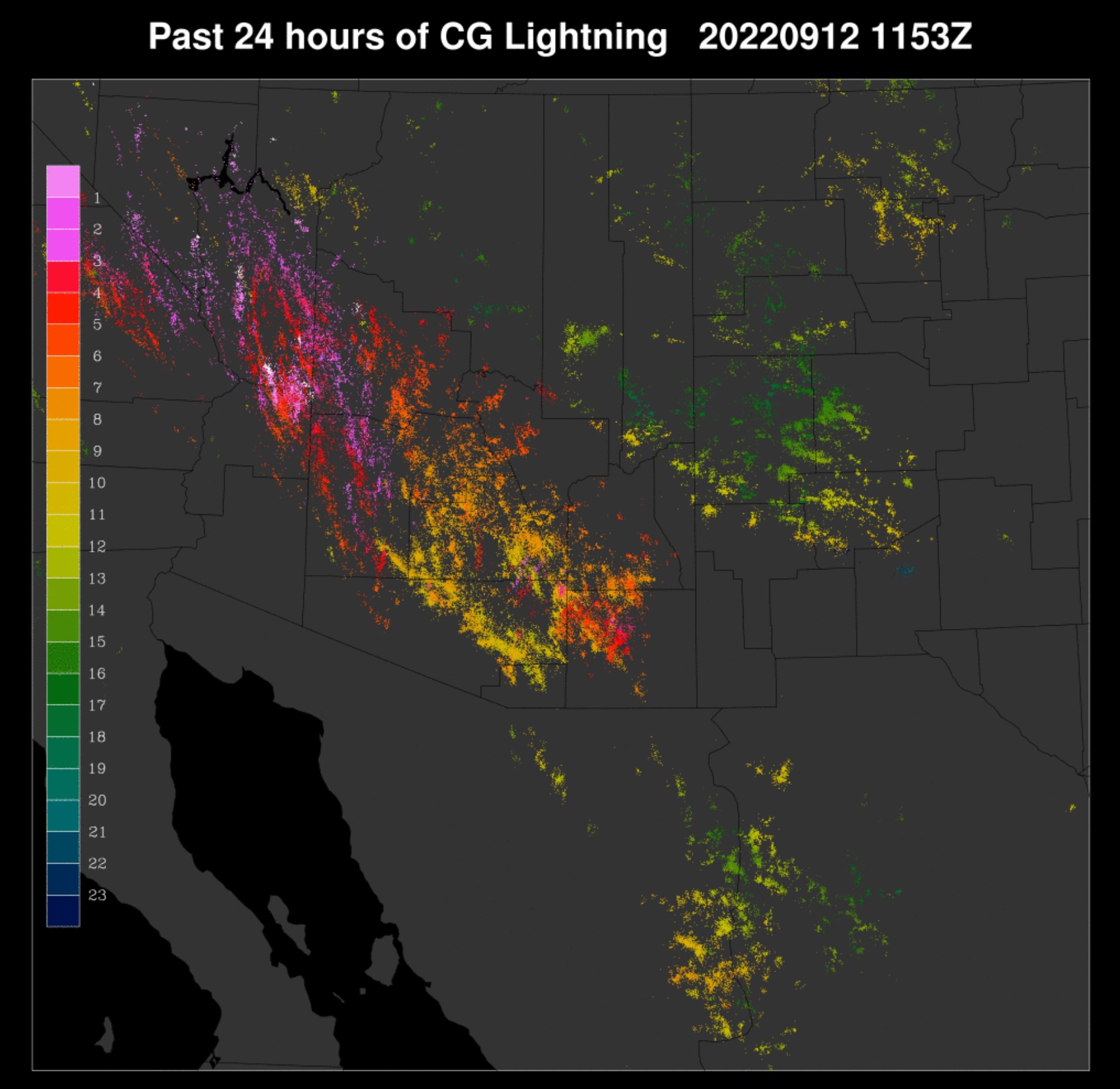
It was a very active evening for the lower deserts near Tucson, through Phoenix, and to NW Arizona.  Severe weather was reported in Phoenix with a gust to 86mph at Sky Harbor.  Very heavy precipitation fell in Green Valley as many stations reported over 3".  


Model performance was quite good, except it missed the heaviest precipitation around Green Valley.  

I kept my eye on the HRRR; it performed poorly around the Phoenix area as it had very little activity.  It wasn't until the afternoon that it came around for strong/severe storms in Phoenix. 12 and 15Z below.  The above WRF runs are 12 or 6Z.


Discussion

I am sorry to announce that this will likely be the last publicly available forecast discussion.  The budget situation has been progressively worsening over the past few years as high UofA overhead rates have made the renewable energy forecast group and my contracts uncompetitive, so we've been unable to secure additional funding.  The University of Arizona refuses to lower the rate and, even worse, has increased it!  Some of our contracts now have a 63% rate.  As these discussions are primarily unfunded, I need to focus my time on the remaining contracts.  Like the others in our group, my position is 100% externally funded, with no significant support from the University of Arizona, so I can no longer justify writing these free discussions.  The model runs will continue to be available to the general public.  I've certainly enjoyed writing these over the years, and I hope you've enjoyed reading them.

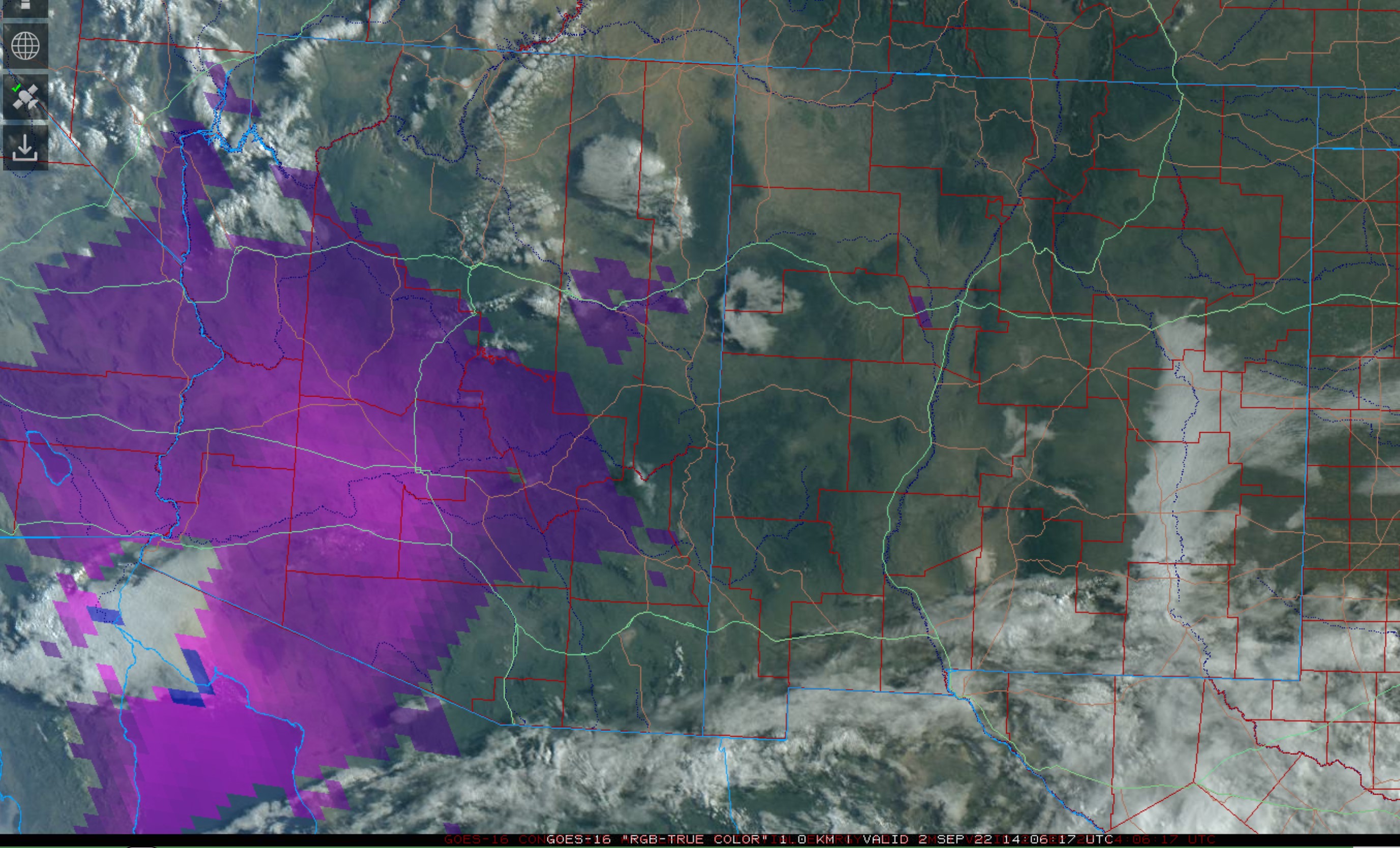
Back to the weather.  Yesterday's model runs all had an extremely active day today, and I wondered if they were overdoing it and not respecting the rule that the next day is mostly down after an active day (yesterday).  I figured the dynamics were offsetting any stabilization.  Both Tucson and Phoenix have quite worked over vertical profiles with minimal MLCAPE.  The vertical shear wind profile is quite good, and if there was enough, CAPE would certainly support organization and mini-supercells.
Phoenix has a good directional shear profile as well but limited CAPE.  It is clear over most of southern Arizona now, so heating should result in better CAPE by afternoon.  PW has also increased somewhat since yesterday morning but decreased since last night in the wake of the widespread storms.

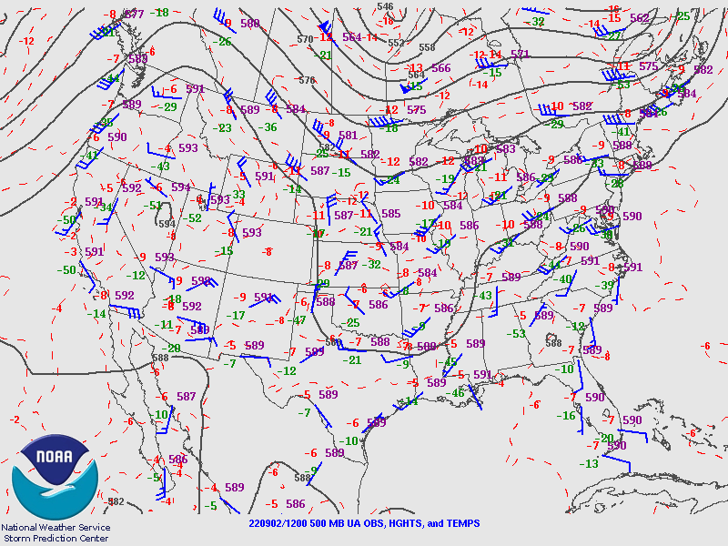
The 500mb trough is still located off the coast of California.  This trough has been attributed to Kay, but I disagree as 500mb temperatures are way too cool for a remnant tropical system, as they are -8 to -9C.  Perhaps it's a blend of a mid-latitude trough and tropical remnant?

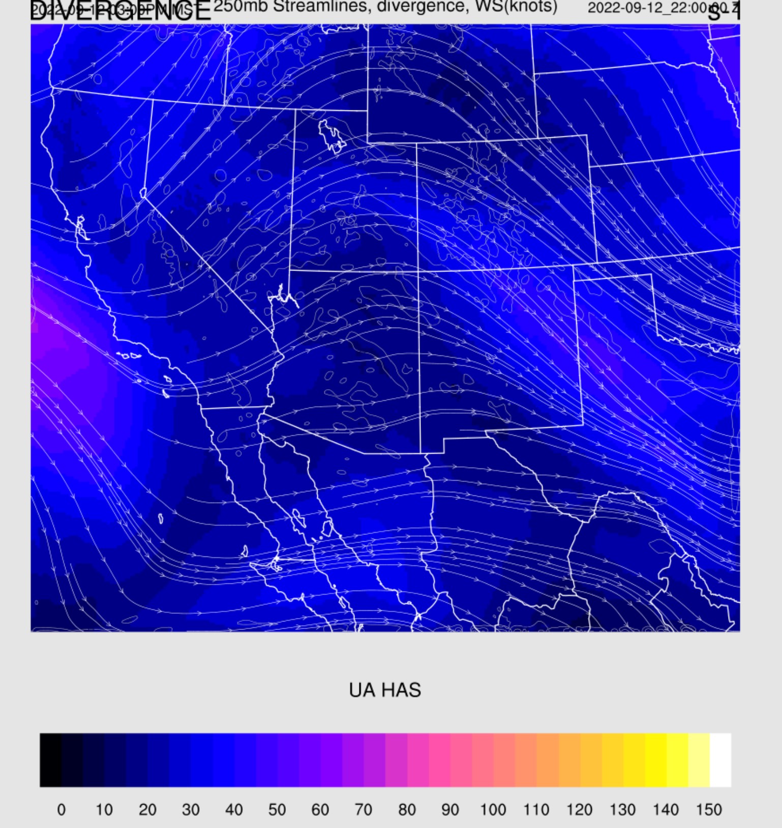
It's more interesting at 300mb, as a sharp trough is moving into western Arizona and has been responsible for the widespread shower and storm activity during the morning hours over northern Arizona and southern Nevada.  The trough will continue to provide favorable divergence for the state today.

Initializations
As mentioned earlier, it's mostly clear over most of southern Arizona.  It's somewhat surprising to see the amount and extent of GOES CAPE as the soundings had only limited amounts.  However, Tucson did have quite a bit of elevated CAPE (1300 J/kg), so perhaps this is what GOES sees.  Cloud initialization was accurate by all as well as CAPE, except for the 12Z RR, which seems to not have enough.  The 9 and 12Z initializations appear more accurate with the placement and structure of the mid/upper-level trough.  Satellite imagery shows a closed circulation located NW of Los Angeles.  

Day 1
Another difference between the forecast from yesterday is the amount of moisture, as it's not as high as the prediction, which was around 40mm.  Instead, it's about 34-36mm by early afternoon.  However, the forecast of decreasing low-level early flow appears to have been verified.

Despite PW not being as high as anticipated, 850mb dewpoint temperatures are favorable at 13 to 14C.

Most runs have moderate to high CAPE by mid-day, mainly over the southern 1/3 of the state, so this looks to be the most active area today.

The forecast Skew-T for Tucson has around 1000 J/kg of CAPE, but the wind profile doesn't have much directional shear as it did at 12Z.  The mixed layer is near the LFC (700mb) by early afternoon, at least in the WRFHRRR.  The WRFRR is not nearly as deeply mixed.   It looks likely that storms don't develop as early as was predicted from yesterday's runs.

At 250mb, favorable divergence continues over the state this afternoon.

The mid-level trough slowly moves east, resulting in moderate SW flow over Arizona and favorable temperatures of -8 to -10C.

Model runs disagree on the timing of convective initiation around Tucson.  The 12Z WRFHRR and other earlier runs, say around 3-4pm for Tucson.

The WRFGFS and 12Z WRFRR don't get going until early evening.  In any case, storms are likely in and near Tucson.  

The main threat seems to be heavy rain.  Precipitation amounts could exceed 2" in some locations.  Isolated borderline severe winds are also possible with a few storms.

IMO, a repeat performance of storms in Phoenix is going to be difficult due to the previous activity and all the reasons listed below.  The forecast Skew-T, like in Tucson, doesn't have as good directional shear as earlier in the day.  CAPE is also marginal, around 900 J/kg.  The PBL isn't mixed very deeply (LFC 700mb), and there is a weak inversion on top of the mixed layer.  

Like yesterday, the Tucson area storms try to make a run along I-10 towards Phoenix.  Other parts of SE Arizona also see strong to severe storms.

Even though there was a lot of negativity regarding the Phoenix forecast sounding, we still have favorable dynamics from the trough.  Some runs develop strong/marginal severe storms in the Phoenix area this evening, while others have nothing.


Day 2
A drying trend sets in as the trough lifts out.  Far SE Arizona has a decent amount of CAPE, so widespread activity is expected there.


Sunday, September 11, 2022

20220911

 Discussion

Kay remnants continue to spin off the SoCal coast resulting in SE flow over Arizona.  At 500mb, a remnant circulation also remains.  Elsewhere, the monster west coast ridge is still present but has weakened some what.  Cool air is present over Arizona with -8 to -9C, and based on this and the fact that considerable moisture has returned to the state, it should be an active day.


There is also an upper-level trough over SoCal, which results in upper-level divergence/difluence over Arizona.


Moisture is generally around 30-35mm from Tucson to Phoenix.  The cool air in the mid-levels results in a decent amount of CAPE, nearly 800 J/kg.  Steering flow isn't bad, with 20 knots of SSE flow.  Westerlies dominate above 500mb.

Phoenix looks similar, except for a strong subsidence inversion above 500mb.  It's unclear if this will negatively affect deep convection later today.

GOES CAPE is present this morning over much of south-central Arizona.  Another positive indicator for lower elevation deep convection.


Day 1
What a wild weather week it has been for the western CONUS, and now, it looks like Arizona is going to get in on the action.   Moisture has increased due to the southeasterly flow around Kay, and by afternoon 850mb dew-points are favorable for deep convection from an N/S line, from about Tucson, westward.  Somewhat drier air and southeasterly flow dominate far SE Arizona and into NM, resulting in only limited activity there.

CAPE mirrors the 850mb Td and is moderate from Tucson and up to Phoenix and sufficient to support deep convection.

The Tucson vertical profile looks quite good, with around 1000 J/kg CAPE, good E to SE steering, SW aloft, and even a little low-level westerly winds providing a bit of shear.  There aren't any strong inversions  so it should be pretty active by later in the afternoon.

There is a unanimous agreement with all the morning runs to develop widespread storms in and around Tucson by late afternoon or early evening.  However, looking closely, most runs keep most of the deep convection over the higher terrain, but a few storms are possible in the valley.

Storms move into Pinal County and eventually into Phoenix this evening.  A strong outflow boundary proceeds the storms, resulting in a big dust storm.

Like Tucson, the Phoenix forecast Skew-T looks quite good as the steering is favorable, and there is a moderate amount of CAPE. The PBL could be mixed deeper, but the strong outflow boundaries might be sufficient.   A few runs have low-level westerlies.

There is quite a bit of spread with the Phoenix forecast.  On the low end, some runs have storms dying as they move into the valley.  Others have strong storms. The middle-of-the-road forecast is some storms, but most skirting around the valley.

Day 2
A very active day is expected as moisture remains while a trough in the westerlies moves across the state.  The first transition event of the season.


An upper trough that starts to move into southern Arizona also provides some favorable upper-level divergence/difluence.


PW increases somewhat and is high over much of southern and central Arizona.  The low-level easterly flow also decreases, allowing moisture to move back to the east.


CAPE is relatively high, with most areas ranging from 1000-1500 J/kg.  

Tucson is primed for significant early afternoon low-topped deep convection.  CAPE is over 1000 J/kg, and there is some directional shear in the lower troposphere, resulting in some organization of storms and possible mini-supercells.

Some storms could be severe and may produce large hail.

Phoenix doesn't have a directional shear profile as favorable, but CAPE is good, with over 1200 J/kg.  A good outflow boundary should kick off the party despite the weak inversion on top of the mixed layer.

Storm coverage continues to increase during the late afternoon hours and, like today, moves up I-10 towards Phoenix.  Some of these storms are likely to be severe.

Another very strong to severe outflow boundary moves into Phoenix, probably with plenty of dust, followed by considerable deep convection.


Friday, September 2, 2022

20220902

 Previous Forecast

Last night, storms moved off of the Rim and into the lower elevations, south of Phoenix, and managed to go all the way to Yuma County. There is some evidence that they may have come all the way from the Chuska Mountains in NE, Arizona.

I debated about a discussion yesterday but ultimately decided against it as there was no clear model consensus.  As seen below, both the WRFRR and GFS(!) predicted this event.


I also looked at the HRRR, but it was like the WRFHRRR.  A student did a project this summer looking at last year's performance of the WRFRR vs. the HRRR and found that the WRFRR wasn't as good in the first 6-12 hours, a little better for 12-18 hours, and much better in the 18-24 hour window.  We attributed the relatively poor performance of the WRF to spin-up issues, as the WRF is cold started, while the HRRR is warm/hot started. (I think)


Discussion

The big news is tropical storm Javier, just to the southwest of southern Baja.  Widespread storms continue over the southern and central Gulf of California.  Unfortunately, Suominet seems to be down for good as there has been no response to my emails, as almost all stations are now missing.  It's sad and pathetic that such an essential and inexpensive data network was allowed to die.  Without the high temporal resolution data, it's hard to judge short-term and long-term moisture advection.  GOES PW can partially fill the gap, but not where there are clouds. 

Phoenix has around 40mm of PW, but MLCAPE is only 553 J/kg.  There is quite a bit of elevated CAPE, 1200 J/kg, and this CAPE appears to be the source of the overnight storms.  A strong subsidence inversion is present at 500mb and may be trouble for deep convection later today/tonight.  Steering flow is good from the ENE at 20-25 knots, but there are any low-level westerlies to provide any shear.  This may change as a strong (at least at the surface) Gulf Surge is underway at Yuma.  Without Suominet PW data or a Yuma sounding, it is impossible to determine the Surge's depth.


Tucson has almost no CAPE and two inversions, so it's not looking good there.


There was a large inverted trough moving across far northern Mexico the past few days, but it's becoming washed out and hard to find on the 500mb map.  Satellite imagery shows it to be located somewhere over the northern GofC.  A broad ridge dominates the western CONUS.  500mb temperatures are pretty cool over the SW CONUS, but as the soundings from Phoenix and Tucson show, there is a strong inversion at or above 500mb.

700mb shows the strong ENE steering flow, but without decent low-level moisture, this sort of pattern results in minimal activity, as was evident during the past few days.  That seems to be changing with the surge event, probably due to Javier, which is underway now.

Initializations

I took a quick look at the initializations and found no significant problems.  Note the decent CAPE from Phoenix and west of there.  CAPE was also initialized well.

Day 1

This afternoon, Javier continues to spin off of southern Baja resulting in low-level flow up the Gulf of California and a weak Surge event for Arizona.


The Surge continues to be shallow, but with afternoon mixing and light and variable 850mb winds, 850mb dewpoints increase into a favorable 14C to 15C for central and western Arizona.


As expected, CAPE is moderate to very high with this much moisture at 850mb.  SE Arizona is under the influence of downsloping easterly flow, so CAPE is minimal.  It is also dry over much of NE Arizona, resulting in limited CAPE. Still, moisture/CAPE has made it into the moderately high terrain north and east of Phoenix, resulting in deep convection later today.


There is excellent model consensus in developing scattered storms in these areas by later in the afternoon.


It will be difficult for Phoenix to break the cap at the top of the mixed layer, plus the PBL is not mixed deeply. Besides that, the forecast Skew-T looks pretty good, with a lot of CAPE, some low-level shear, and 20-25 knot easterly steering flow.  While the subsidence inversion is still present, it appears less intense than the morning-sounding data.  As usual, it's a difficult call for Phoenix proper.

There is a unanimous consensus that the storms split and go around Phoenix this evening.  Some of these storms are likely to produce severe winds.


Morning DCAPE was nearly 1400 J/kg which supports the forecast of a few storms producing severe winds.  Storms generally die out as they move to the southwest due to the strong cap at the top of the mixed layer, but one or two might make it to the Colorado River valley.


Day 2

Javier moves slowly to the NW but is close enough to continue a weak surge into southwestern Arizona.  However, low-level easterly flow dominates most of the eastern 1/2 of the state.

850mb is especially sad, as significant drying from subsidence/downsloping will occur, even into central Arizona.


West of the dry air, CAPE is still moderate to high but strongly capped.


Activity is limited to NW Arizona during the late afternoon hour.  Later, another area of storms formed earlier over NE Arizona manages to make it to near Phoenix late in the evening but dies out before moving into the lower elevations.