Saturday, July 30, 2022

20220730

 Previous Forecast

The model forecasts were pretty good, especially the 6Z WRFGFS.  The WRFHRRR also got the very heavy rain over in Texas.


Discussion

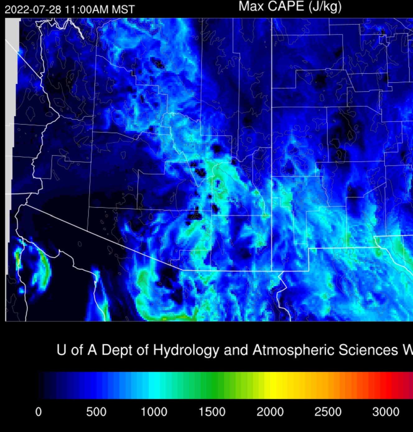
Finally, some real action looks to be in the cards today, so I'll get right to the good part.  The Tucson sounding has an impressive 1200 J/kg of MLCAPE, which is the best in some time.  It also had a surface dewpoint of 70F, which is unusual for Tucson.  PW is a very moist 45mm.  The steering also appears to be better, with 15 knots at 700mb.  The negative is the subsidence inversion at 500mb, but it shouldn't be a problem with enough heating.  Anvil-level winds could be better, but at least they are 45 degrees from the steering flow.

Phoenix is also much improved with nearly 900 J/kg of MLCAPE.  MU is a respectable 1300 J/kg.  PW is still a very high 52mm.  In fact, PW in SW Arizona and far NW Sonora is incredible.  Yuma is 57mm, and Puerto Penasco peaked at 62mm this morning!

The center of the 500mb anticyclone is around northern Nevada, but the flow is still primarily light and variable over Arizona.  500mb temperatures are quite high at -6 to -4C.  It looks like an old MCV or IT is between Flagstaff and Vegas.


300mb is interesting as an upper-level IT is moving westward from the Big Bend.  This feature puts NW Mexico and southern Arizona under favorable upper divergence/difluence.  Satellite imagery shows another TUTT located over the central Gulf of Mexico, moving our way. 


Initializations
Much of eastern and central Arizona is clear, for once.  Cloud initializations were fairly good.  The 6Z GFS was a bit too cloud over the Phoenix area.  The IT over Vegas was also well initialized.  The 12Z WRFRR did develop too much activity south of Flagstaff but was fine elsewhere.  There is no favored initialization, and model accuracy should be pretty good today.


Day 1

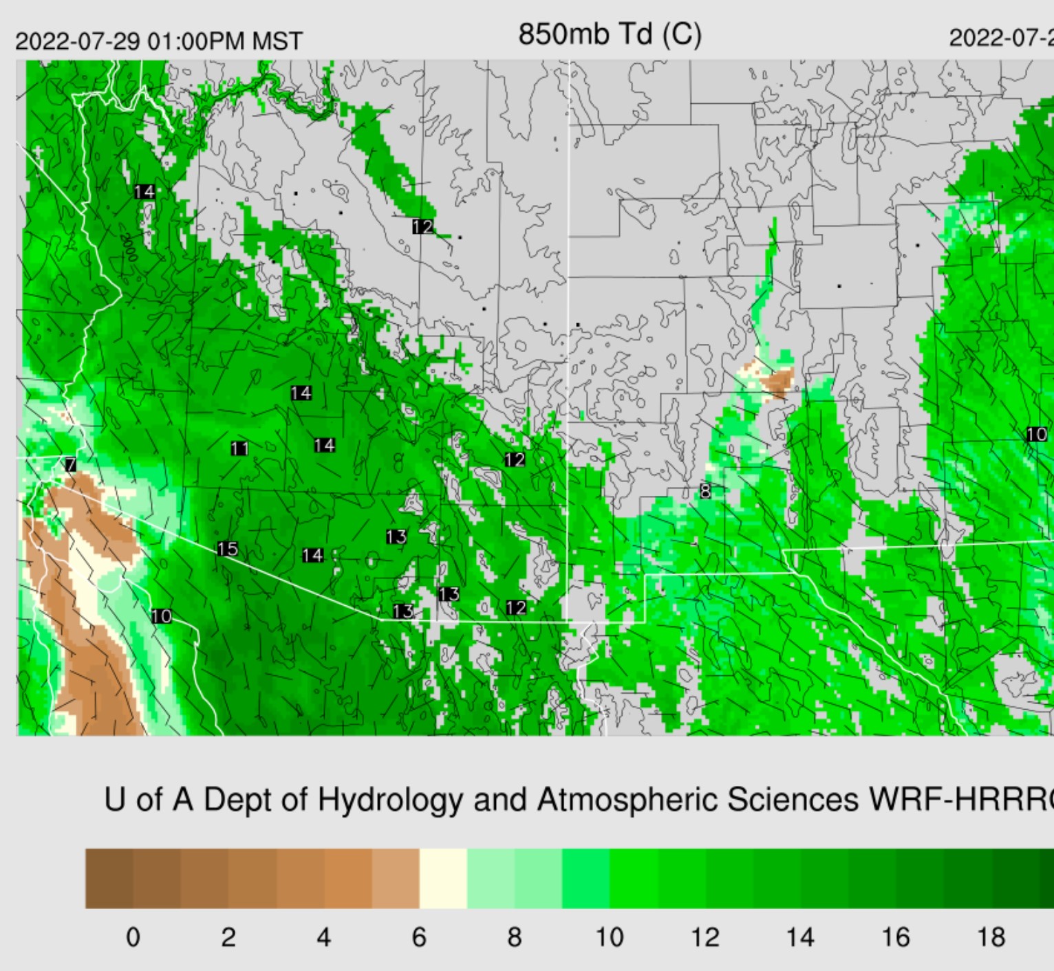
"Here we go," finally!  After days of boring gunked-over conditions for Tucson and Phoenix, the situation looks favorable for strong/severe storms in Tucson and perhaps Phoenix.  I'm amazed by the longevity of the Gulf Surge as it's been going strong for many days now and continues to do so this morning.  PW remains at extreme levels over southwestern Arizona and very high everywhere else.


The WRF has been trying to weaken the Surge over the past few days, but according to the 850mb, that still isn't the case, and it's actually deepened, up to 850mb again.  The firehose of moisture continues except for SE Arizona, where somewhat drier air has moved in.  As mentioned yesterday, this has resulted in a convergence zone over SE Arizona and could be a trigger point for storm development.


With some decent heating, CAPE becomes moderate to high for most of southern and central Arizona.


By mid-afternoon, the morning runs consistently develop strong to isolated severe storms over the higher terrain of western Cochise and eastern Pima Counties.  These storms move into the Tucson area.


The Skew-T forecast supports a big day for Tucson with 1500 J/kg of CAPE, low-level shear, and good mid-level steering.  Storms should easily push off into the valley and break the weak cap at the top of the mixed layer.  Heavy rain and wet microbursts are likely.

It's looking pretty good for Phoenix, based on the Skew-T.  The PBL is mixed deeply, CAPE is 1600 J/kg, and there isn't a cap holding things back.  Any outflows should get things going.


The morning runs are about 50/50 for strong/severe storms in the Phoenix area.  Strong to severe storms continue south of Phoenix and central and western Pima County.


The 12Z WRFHRRR is especially active, with widespread strong to severe storms this evening.  The forecast Skew-T certainly supports something like this.


Activity may continue all the way to the Colorado river.  Also, some runs develop a large MCS in northern Sonora and into southern Arizona for another round of storms.  It's very unusual for two waves of storms, so I don't have much confidence in Tucson getting hit again.


MCS formation is likely, though, as difluence/divergence over northern Sonora is pronounced.


No Day 2.


Friday, July 29, 2022

20220729

 Previous Forecast

Another day of crazy heavy rain for some areas of the state.   The Tucson and Phoenix areas had some activity, but itmainlyostly on the light side, with "light" now defined as <1".


In general, the forecasts didn't have enough precipitation.  The WRFGFS was especially bad in western Arizona.  It was another complex situation, so I'm not surprised.

Here's the 3-day QPE.  Now that's crazy.


Discussion

Moisture has decreased by about 5mm over the southern 1/2 of the state but is still very high.  In addition, an outflow enhanced Surge is underway as a small MCS moved across northern Sonora last night.  Moisture is increasing again over southwestern Arizona as PW is increasing at Yuma and Puerto Penasco.  Tucson's airmass is worked-over with only minimal CAPE.  Winds are quite strong from the SE, around 700mb.  This may be due to the passing of the MCV, which is north of Casa Grande.  It's going to take a fair amount of heating to get the sounding to recover.  

Since the sounding was taken, Phoenix has had some showers and weak storms, so it's not representative of the current condition according to GOES.  It has cleared a little over Phoenix, and some CAPE re GOES.


The 500mb pattern remains the same as a ridge dominates the western CONUS.  A broad IT continues to spin over Arizona and northern Sonora, with multiple MCVs, embedded.  

Another in a series of TUTTs is moving across Northern Mexico.  Once again, it will provide some forcing via upper divergence.

Initializations

The 6z runs had the central Arizona MCV initialized too strong and too far south.  It was over Tucson at 15Z.  The 12Z initializations were more accurate, except the WRFRR crashed after a few hours.  As usual, it also had too much deep convection within the run's first few hours.  So, it looks like the WRFHRR is the favored run.

Day 1
So much for the slight drying that was forecasted yesterday.  A shallow Surge continues to advect very high PW air into the state.

The forecast for improved steering flow appears to be coming true as, by early afternoon, southeasterly 600mb flow is quite strong over much of eastern Arizona.

CAPE continues to mostly be below 1000 J/kg for most of the state, unfortunately.  Far northern and southeastern Arizona appears to be the favored locations.  SE Arizona is also clear.

By mid-afternoon, storms are scattered about the mid and higher elevations of the state.


As always, some good and some bad with the Tucson forecast Skew-T.  CAPE is pretty good at around 900 J/kg, and the vertical wind profile is better due to good steering. The negatives are a weak inversion at the top of the mixed layer, plus quite a bit of subsidence warming above 500mb.

There is no consensus for Tucson.  The WRFHRRR moves storms r to Tucson, but they dissipate as they move into the valley.

The 9Z RR manages to move an area of storms into Tucson.  Unlikely, IMO, but Tucson is due.

It's unlikely anything will happen in Phoenix this evening as they are weakly capped, and CAPE is only around 800 J/kg.  More likely is some early morning activity again.

Day 2
Central and western Arizona remains very moist, with 850mb dewpoint temperatures from 13-16C.  However, dry air advection is underway over far SE Arizona and has set up a convergence zone in far eastern Pima and Pinal Counties.

CAPE is high for SW and SC Arizona, so activity should pick up significantly for those areas.

The WRFHRRR moves a line of storms from the higher terrain of far southcentral Arizona into the Phoenix area tomorrow evening.  It looks too good to be true, especially as most other runs don't have this much activity. 


Thursday, July 28, 2022

20220728


Previous Forecast
Rain, rain, and more rain.  Except for Phoenix and most of Tucson.
Not much to say about the forecasts except that they busted in the Tucson area as heavy rain never materialized.  Anvils came in and shut everything down.

Impressive 72-hour QPE.


Discussion
See yesterday's.  

Initializations
There isn't much to write as the computer cluster got stuck, and no model runs were main until I could log in this morning.  I could not log in earlier as my power was out starting late afternoon yesterday.  Widespread clouds and scattered showers, and storms continue this morning.  A large IT is located over Arizona, with a few MCVs embedded.  I restarted the 6Z GFS, and the 12Z runs are available.  Once again, the WRFRR went wild with deep convection shortly after it began, so it's out.  The GFS and HRRR did have reasonable initializations of cloud and two MCVs, one in SE Arizona and another northwest of Phoenix, so they should be OK.

Day 1
Yesterday's slight drying forecast did not occur, and PW is still above 50mm over the lower deserts as a weak Surge continues. 850mb dewpoints are still very high at 12-15C.

The 850mb low continues slowly moving west, and the Gulf of California is no longer under its southerly flow.  In fact, drier air is moving into the northern Gulf, at least at 850mb.

CAPE is generally below 1200 J/kg but more than sufficient for storms over the mid and high elevations.  Like yesterday, it will depend on the location of the various MCVs and how much the clouds part for heating.

The WRFHRRR and GFS fire up storms early and are active just after noon.  It's not really possible to say where and when, as it, all depends on heating, and WRF can't forecast at this fine scale.

Tucson's Skew-T forecast plot still has the potential for strong storms and heavy rain as CAPE is around 1000 J/kg and PW is a very moist 45mm.  The negatives are still poor steering and upper winds potentially blowing anvils out from activity over higher terrain to the NE.  I had a question about why there is so little lightning activity.  Our airmass is tropical and not much different from Acapulco, resulting in skinny CAPE profiles, weak upward velocities, and minimal charge separation.  In addition, the cloud microphysics is mainly warm rain, with less graupel, ice, and mixed phase.

The story for Phoenix also remains unchanged.  CAPE is marginal, steering flow very light, a weak cap on top of the mixed layer, and stronger upper-level winds advecting anvils over the valley.  PW remains very high at 50mm, so in the unlikely event anything develops, rain accumulation could be extreme.

The four-panel plots are missing.  The WRFHRRR keeps most/all activity away from Tucson and Phoenix.  Elsewhere, amounts could exceed 3" at some locations.

Day Ahead
Very moist air remains over central and eastern Arizona.  There is one slight change as low-level easterly flow increases over southern NM, along with some slight drying.  There is also some drying over far western Arizona.

Steering flow improves for southeastern Arizona, so storms might be able to move off of the higher terrain.


Wednesday, July 27, 2022

20220727

 Previous Forecast

It rained a lot at quite a few locations. Even parts of Tucson got some decent rain.  Phoenix remained quiet as it was mostly cloudy during the morning, which didn't allow much heating.  "Much," meaning Phoenix stayed below 100F.

The WRFRR runs have had significant problems with way too much deep convection firing shortly after initialization, resulting in some inaccurate runs.  For now, some RR runs have been replaced with the HRRR. (0Z, 18Z).  The runs had the right idea, keeping Phoenix quiet and a few storms in Tucson. They also had a handle on the heavy precipitation in Yavapai and Mojave Counties.  Not bad, considering the complex situation.


Discussion

The large inverted trough continues to spin to the east of Arizona.  At 300mb, it's centered over El Paso and continues to Arizona and Sonora in a favorable difluent/divergent upper-level pattern.

At 500mb, the circulation is displaced a bit to the west, near Douglas, AZ.  This circulation might be a large MCV.  It's hard to tell.  There are at least three(!) other MCVs spinning over the state: far NE Arizona, along the Mogollon Rim, and another SW of Phoenix (for a third day).  All are pretty much stuck as the height field over all the southwest is flat, with no flow.  I never recall a situation like this before.

See yesterday's discussion.
PW has increased to 54mm since the 12Z sounding!

Initializations
The one slight change is that there are more clouds this morning.    The HRRR and GFS were pretty good, but again, the RR goes nuts right off the bat, with deep convection from Phoenix and to the southwest.  Those runs will be ignored, at least for those areas.  None of the initializations were able to capture the complex MCV situation.  They generally have a broad oblong weak cyclonic circulation from NE Arizona to SW Arizona.  Not unreasonable, IMO.  They are missing the little MCV over far SE Arizona and instead have a broad area of cyclonic circulation centered south of the border.  Also, not unreasonable.  The 12Z HRRR seems to have the best handle on the situation.
 

Day 1
Our good friend, the 850mb cyclonic circulation just west of Baja moves a bit more to the west and weakens.  This results in a mainly light and variable flow over the Gulf of California and into Arizona.  So, at least at 850mb, the Surge has ended.

At the surface, the Surge is weaker but still going.  PW remains extremely high.

CAPE is low to moderate for much of eastern 1/2 of the state.   It's another day of heavy rain with slow-moving storms for those mid to high-elevation locations. There isn't much from Phoenix and to the southwest, which looks reasonable.  Thus, not much activity is expected there.

Storms fire before noon for locations that get partial sun.  It takes SE Arizona a while to get going, but by mid-afternoon, storms are present east of Tucson.  Once again, other strong storms with extremely heavy rain are present in Coconino and Yavapai Counties.  


It's looking good for Tucson later today as CAPE becomes relatively high, above 1500 J/kg, and there is a little bit of steering flow at 5-10 knots and a little low-level shear.  The PBL has a weak inversion at the top but is approaching the LFC, which was a low 750mb.  Anvils could be a problem if storms form to the northeast.


There is a remarkable consistency between runs as they all develop a broken line of strong to isolated severe storms (wet microbursts) from eastern Pima county up towards the Rim later this afternoon and early evening.


It's hard to say what will happen as the storms move toward Phoenix.  CAPE isn't all that impressive despite 48mm of PW.  However, the PBL is mixed nearly to the LFC, so even a weak outflow could trigger deep convection.  If storms do form, they aren't going anywhere as mid-level flow is light and variable.  

Storms struggle to form in the Phoenix area, at least according to WRF.  My guess is there will be a bit more activity, considering Phoenix is starting to clear.  As of 17Z, storms are already beginning to fire north of the valley, which may result in anvils later, so maybe not.  We'll have to wait and see.


Again, very heavy rain in some locations, including Tucson.


Day 2
More of the same as a weak Surge continues.