Discussion
The center of the 500mb anticyclone has been slowly moving westward during the past few days and is now located around the Four Corners. Most of Arizona is now in light easterly flow, and temperatures are relatively cool, at around -7C.
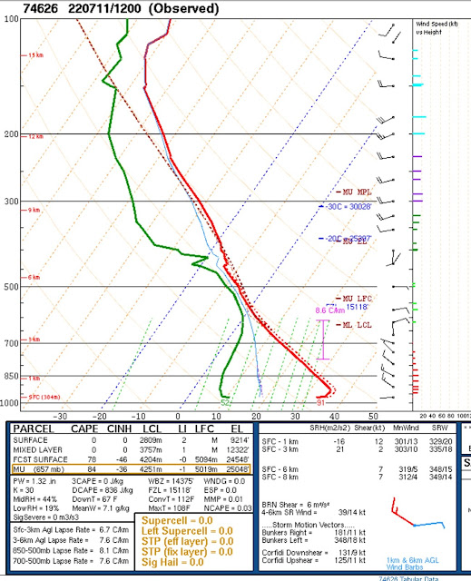
The problem over the past few days has been the lack of moisture and CAPE. This continues to be a problem today as PW is only around 32mm at Tucson and 30mm at Phoenix. CAPE from the morning upper-air data is zero at both Tucson and Phoenix. Tucson has weak steering flow, but the upper flow is out of the west, so anvils will blow away from storm motion, assuming easterly mid-level flow increases.
The vertical wind profile looks better at Phoenix with low-level NW winds, mid-level easterlies, and upper-level westerlies. The low-level NW winds are interesting as it looks like a Gulf Surge signature, but without the moisture. SW Arizona is dry, so even with a Surge like flow, there isn't any moisture to advect yet. Puerto Penasco has seen PW slowly increase but is still only 37mm. The Yuma vertical profile has quite a strong southerly flow from just above the surface to 700mb. Not really a Surge as surface winds and dewpoints are low, but interesting nonetheless.
Day 1
It looks like a Gulf Surge by this afternoon as low-level winds have the characteristics. However, moisture advection is minimal, and PW doesn't increase much, if at all.
850 doesn't look much better. While the flow is of a Gulf Surge, there isn't much moisture as dewpoints are a marginal 5-8C. Better moisture is lurking just south of the border, though.
Only far eastern and southeastern Arizona will have a decent amount of CAPE. I expect these will be the active areas today.
Storms take a while to get going, and by late afternoon, they are scattered over much of eastern and northern Arizona, moving generally westward.
The wind profile is a classic Rim Shot setup: deep NW low-level flow, NE steering, and W aloft. However, moisture does not increase, and CAPE is minimal. There is a very deep inverted-v profile, so storms nearby are likely to generate strong outflow winds. Phoenix looks about the same, except the NW winds extend from the surface to almost 600mb! CAPE is only a few hundred J/kg, at the most.
Thunderstorms continue to move slowly to the west and are on the doorstep of both Tucson and Phoenix by early evening.
Most runs weaken the storms as they move into Tucson and Phoenix.
But not all! The 9Z WRFRR is the outlier as most runs do not do this.
Day 2
Moisture and CAPE continue to be marginal, at best. Another big negative is dry air advection is underway over southern NM and into eastern Arizona. There is a narrow strip of higher CAPE over southeastern Arizona and up over much of northeastern/central Arizona. These look like the only areas for storms tomorrow.
A few runs try and move storms into the Tucson area by late afternoon.


No comments:
Post a Comment
Note: Only a member of this blog may post a comment.