Previous Forecast
It was another active afternoon and evening. Storms developed multiple times north of Phoenix and moved south into the lower elevations. NM really got slammed near Roswell with over 11".

This is shocking to me that one of the runs, the 12Z WRFRR, could predict this extreme event( lower left). Elsewhere, the forecasts were quite good as well.

It looks like central and western Arizona will have another high to low elevation event. I've been keeping my eye on the cutoff low over UT as it reminded me of the multiple-night heavy rain and resulting flood event in Tucson in 2006. A low parked itself around the Four Corners for a few days resulting in storms forming over NE Arizona during the afternoon hours and then making it all the way to southeastern Arizona overnight. Something similar happened yesterday as storms developed over SW Utah and eventually moved across western Arizona early this morning.
2006. Note the lack of sounding data from Mexico...this was the case for many years until SNM got their act together around 5 years ago. It wasn't any fun trying to forecast with no data from upstream.
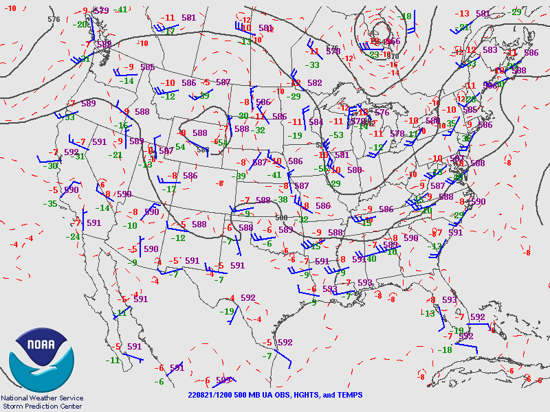
Tucson and Phoenix are quite worked over and have minimal MLCAPE. But, that doesn't seem to matter much in central and western Arizona, as heating has been sufficient for recovery. NE steering flow is excellent, and the upper level is now dominated by south-westerlies. PW has decreased but is still very high.


Initializations
Again, thick clouds are in place over most of southeastern and southcentral Arizona, but clouds and showers are dissipating. It looks like the tropical low is ejecting over the Bootheel of NM. Clouds were initialized accurately by all runs, but the earlier initializations had the NM low too far to the SW.

Day 1
The models say the low-level remnant circulation is still over the northern Gulf of California. Nothing seems evident from the satellite imagery. There is still a lot of deep convection near Hermosillo, though. Afternoon 850mb flow continues to advect 15-16C dewpoints into much of the state.

CAPE is extremely high over the Colorado River but is probably strongly capped. CAPE recovers from the Rim to the south and is high by afternoon. CAPE has improved over southeastern Arizona, so a few storms are possible there as well.

Storms develop around Flagstaff by early afternoon and are threatening Phoenix by late afternoon. All morning runs are very similar, so confidence is high.

I might as well call it now... "here we go." This is one of Phoenix's best model forecast Skew-Ts of the year. Low-level shear, mid-level steering, westerly upper-level. CAPE is very high, from 2000-2300 J/kg. Phoenix is strongly capped but should be broken with the monster storms moving in.

Many runs predict widespread strong to severe winds as the storms move into the Phoenix area.

Some earlier runs have storms clipping the west side of Phoenix, but later runs have storms in and around Phoenix.

Earlier runs were much more active in and around Tucson, but the 12Z runs have backed off, which makes sense with only 800 CAPE. Other features are positive: low-level shear, steering, upper winds, and a minimal inversion on top of the mixed layer. It could happen.

There is a big difference between the 12Z WRFRR and WRFHRRR as the WRFRR keeps the line of storms going into SW Arizona and has quite a bit of activity around Tucson. Maybe 15Z runs will shed some light on the situation.

Day 2
The atmosphere is highly modified in central and western Arizona, but much of southeastern Arizona has a bit more CAPE.


No comments:
Post a Comment
Note: Only a member of this blog may post a comment.