Wednesday, June 30, 2021

20210630

 Previous Forecast

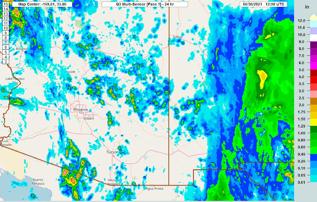
Storms were restricted to mainly the higher elevations of the state.  Strong storms developed over central Pima County and south into Sonora.


The WRFGFS and NAM were the better performing runs as the WRFRR generally didn't have enough activity.


Discussion

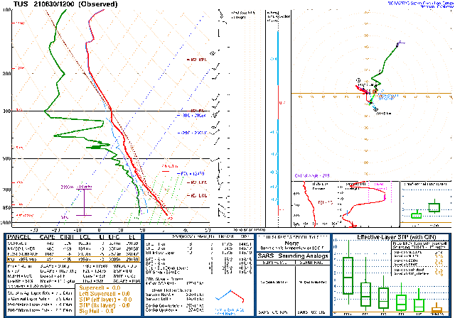
I'm having major issues with the incoming initialization data resulting in many missed and delayed runs.  Thus, I'll be making this discussion very short.  The 500mb pattern is quite complex as a closed low is located over southern Utah, under the Omega block.  Arizona is in generally light westerly flow and favorable temperatures of around -8 to -9C.


There is a weak trough over western Arizona, and this appears to be responsible for the showers and a few thunderstorms over western Arizona.


Moisture has continued to increase, resulting in some CAPE for both Tucson and Phoenix.


Day 1
Moisture has continued to increase over central and western Arizona, and by early afternoon, PW is in the low 40mm range.

With more moisture and coolish air at 500mb, CAPE is quite high over central and southwestern Arizona.  Much of eastern Arizona had downslope easterly flow, and despite quite wet air, CAPE is low.  It looks like an active day for areas to the west of this dividing line.

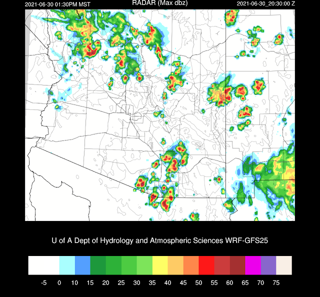
Storms are active by early afternoon, with quite a bit of activity around the Tucson area.  

The 12Z WRFNAM is just now out far enough to look at this afternoon, and it has a bit less activity for the Tucson area.

The WRFGFS continues to expand the area of storms over southern Arizona into the evening hours, similar to yesterday's runs.  

The 12Z WRFNAM has much less activity this evening.  I have no idea which is more accurate.


No Day 2 forecast at this time.


Tuesday, June 29, 2021

20210629

 Previous Forecast

Very heavy rain fell over the past 24 hours over SE NM and south into Texas.  MRMS Q3 says as much as 6 inches.  A few storms developed over eastern Arizona and moved south towards Tucson, and other stronger storms developed just south of Santa Cruz County.


Generally, the location and amounts of precipitation were forecast well, including the area of extreme rain in NM/TX.  However, the strong winds never materialized at either Tucson or Phoenix.  The 15Z WRFRR and the 6Z WRFGFS (below) were quite accurate.


Discussion

The upper-air pattern hasn't changed much as the Omega block is still in place over the NW CONUS and a broad trough over the central into the southwestern US.  The NM cutoff low has drifted northward over the AZ/NM border and is responsible for the heavy rain and widespread clouds in NM.


Moisture continues to increase as PW values are now in the 25-32mm range.  Both the Tucson and Phoenix soundings indicated a bit of CAPE, resulting in storm activity later.  Tucson had quite a bit of cooling in the lowest levels. Thus, there is a cap in place.  Phoenix is well mixed already with elevated CAPE thus the ongoing activity to the NW and SW.


Enrique has weakened and has lost all deep convection as it approaches southern Baja.  Mid-level moisture continues to stream to the NE into NM.  Looks like their drought is over, at least for central and eastern NM.


Initializations

It's a complicated situation this morning, so it will be tough to get a good initialization.  The 6Z GFS looks quite good as it has the morning activity over NW Arizona and the widespread clouds and rain in NM.  The 12Z  RR is also pretty good but has a bit too many clouds around the Phoenix area.  The 12Z NAM was unable to initialize the Arizona morning activity but did well in NM.  PW errors are mainly under 2mm for all initializations.  I think the 6Z GFS was the best, but there are no major issues with any of them.

Day 1

Moisture continues to increase today due to advection from both the east and up the Gulf of California.

CAPE has also increased over central and western Arizona and is sufficient to support scattered storms later today.

By mid-afternoon, scattered storms are located over much of the higher terrain of the state.  The 12Z WRFNAM is probably too active as it had more heating (and moisture) than the other more recent runs.  The 6Z WRFGFS (below) falls somewhere in the middle.

The Phoenix area PBL becomes deeply mixed by late afternoon and 3-600 J/kg of CAPE, which is likely to support scattered activity in the area.  Steering flow is light and variable, so storms probably won't move much or become organized.


The situation is similar in Tucson as some CAPE is present.  The steering flow is a bit better.

A few storms may develop by early evening in and around the Tucson and Phoenix areas.  

Not much precipitation is expected, but there could be some strong winds and blowing dust.

Day 2

PW continues to increase and is over 40mm at some locations, which is very wet for this time of year.  Thus, the risk of heavy rain increases for any storms that may form.

With the increasing moisture comes increased CAPE.  It becomes quite high over southcentral and central Arizona, which will support stronger and more widespread storm activity.

Steering flow is a bit more favorable for southeastern Arizona, with about 5-10 knots from the NE, which will help move higher elevation storms towards the lower deserts.  Some more positives are 500mb temperatures around -10C and eastern Arizona generally under cyclonic flow.  Tomorrow looks like the best chance for storms for Tucson and Phoenix so far this season.


Storms develop over the higher terrain during the afternoon hours and maybe even some activity in the Tucson area.


Storms continue into the evening, covering areas of the lower elevations of south-central Arizona.


Monday, June 28, 2021

20210628

It's a new season, and there have been some changes to the WRF runs.  I've always had two different configurations and always wanted to avoid switching back and forth, depending on the season.  I think I have found the Holy Grail, which is the MYNN PBL scheme with EDMF turned on.  Also, icloud=3 was modified to increase the amount of supercooled liquid water clouds, which was seriously lacking in some situations.  I've also discovered issues with soil moisture initialization errors by some of the NCEP model initializations.  The Tucson and Phoenix areas can have anomalously high soil moisture, and this has been corrected.

Overview

This certainly isn't a typical monsoon pattern 500mb map as a broad trough is in place over the central CONUS and the bizarre omega block pattern over the NW CONUS.  But who cares if it results in some precipitation and lower temperatures?!  There is a weak mid-level cyclonic circulation over NM, resulting in widespread clouds and showers there and definitely not a typical pattern.  


Moisture has increased during the past 24 hours due to moisture advection from NM and Chihuahua. PW is in the 20-25mm range over southern Arizona.  The boundary of the wet air can be seen clearly from the 12Z RR initialization.  


Lastly, Hurricane Enrique is approaching the southern Gulf of California, resulting in increased moisture over the Gulf.  The purple-blue boundary is 38mm, blue-green is 25mm.


Model Initializations

According to satellite and upper-air data, the 700-500mb low is centered near Chihuahua City, resulting in thick clouds through most of NM.  All Mexican upper-air stations reported this morning, and looking back a few days, I see this has been generally the case.   Generally, the initializations are accurate, except the 12Z RR has the thick clouds initialized into far eastern Arizona, which is incorrect.  12Z PW initializations struggled as the NAM has a general 1-5mm wet bias while the RR is the opposite.  6Z NAM and GFS had minimal errors.  I'm not sure the 12Z errors are large enough to impact the model forecasts, so there is no clear favorite.  (maybe the 12Z GFS later?)

Day 1

Moisture continues to advect into southeastern Arizona during the morning hours but appears to be mixing out as the afternoon goes on.  Despite this, enough moisture appears to be present to support some activity later today.


Combined with heating, CAPE is high enough to support storms over southeastern Arizona.


Storms form this afternoon over the higher terrain of far eastern Arizona and south of Tucson.  The WRFNAM has less activity along the border than the WRFRR.


 Northeasterly steering flow is favorable for storms to move off of the higher terrain of eastern Arizona into the lower elevations as the closed cyclonic circulation drifts northward towards far SW NM.


Tucson does have sufficient CAPE to support some activity.  The boundary layer is also mixed deeply, so a strong outflow boundary will be sufficient to trigger storms.  CAPE isn't all that great, so storms won't be that strong, except for winds, which may be strong due to the large sub-cloud mixed layer.

The various runs do have scattered storms around parts of SE Arizona, including the Tucson area, late this afternoon and into the early evening.


Phoenix has a nasty inversion at the top of the mixed layer, so, despite some CAPE, little or no activity is expected.  A few showers and weak storms could form over the higher terrain just to the northeast, though.


What is likely for Phoenix is a strong outflow boundary moving across the valley from the east by late afternoon.  The runs disagree on the wind speed as the WRFRR has winds around 25-30 knots, while the WRFNAM (below) is quite a bit stronger for both Tucson and Phoenix.  All runs are strong enough for widespread blowing dust with the possibility of a haboob for Pinal and Maricopa Counties.


 Day 2

The upper-level low moves slightly to the west and are over far Southeastern Arizona by mid-day.  Cooler air is present over much of central and western parts of the state, and combined with increasing moisture, more storms will be present.


Moisture advection continues from the east, and the south as a Gulf Surge gets underway, resulting in quite a bit of moisture over the state.  Enrique continues to slowly weaken and moves to around southern Baja resulting in a favorable location to continue moisture advection up the Gulf of California.


While not great, CAPE is sufficient to support scattered storms over much of the state.


By mid-afternoon, scattered storms are present over the higher terrain of central Arizona.  Steering flow is favorable for moving storms into the lower elevations.  


All recent runs forecast scattered storms for the Phoenix area during the early evening hours.