Saturday, August 31, 2019

20190831

Previous Forecast
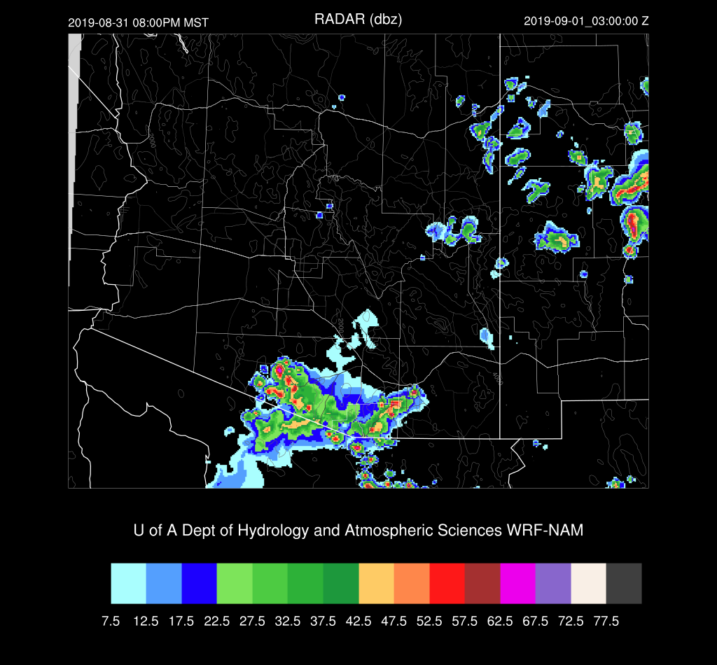
All runs struggled around Tucson as storms developed NE of town during the early afternoon hours which resulted in debris clouds and slight cooling.  This put the kibosh on any further development.  The model runs were too active in and near Tucson.  The WRFNAM was the worst.  The WRFRR had a lot of activity for far southern Arizona, but it was about 30-60 miles too far north.


Initializations
The 500mb pattern is mainly unchanged from yesterday as the high center is located near Vegas/San Diego.  Slightly cooler air is present over the state, ranging from -6 to -9C.  An IT/MCV is situated over the central Gulf of California.   RR and NAM have upper-level features and clouds initialized well.  The 12Z RR PW initialization isn't as good as it normally is as it's too dry over southern Arizona.  The NAM is too wet in Mexico.  15Z RR has only minimal errors and is the favored initialization.

Day 1
The PW trace for Tucson indicated that there was some moisture convergence at the time of the sounding as showers were moving through.  This resulted in the sounding being too wet as PW was 1.59 inches.  The PW trace shows a rapid decrease after 12Z with PW now around 1.3".  This is likely the source of the unusual 12Z WRFRR PW error in southern Arizona as GPSIPW spiked up to 1.75" at 11:45Z.  In any case, there is plenty of moisture about today, and weak moist advection continues into the afternoon, keeping PW around 35mm over the lower elevations.

Steering flow is good over much of southern Arizona as it is easterly around 10-20 knots as the high center is somewhere over northern Arizona.  Temperatures also look good at around -7C.

CAPE is low to moderate across much of southern Arizona while it's nonexistent for northern Arizona.  Hopefully, there will be enough to support deep convection initiation over east-central Arizona so those storms can move towards the lower elevations.

The 15Z WRFRR develops storms do over eastern Arizona during the afternoon hours, but I'm surprised to see that they die as they move to the WSW.  This is much less activity than the forecast from yesterday and less compared to the 12Z forecasts.  The WRFNAM is very active, and moves/develops strong storms over southern Arizona early this evening.  The WRFNAM was too active yesterday, so will that be the case today?  I hope not.

The 12Z WRFRR is similar to the 12Z WRFNAM.  Not a large outbreak in any case.

I don't really understand why the 15Z WRFRR is so inactive. The forecast Skew-T looks very good with a deeply mixed PBL, minimal inversion, >1000 J/kg CAPE, good steering, and low-level wind shear.  We'll have to see what the 15Z WRFRRx has to say.

The WRFNAM does keep some storms going into the evening.

The WRFRRx looks no better for southeastern Arizona.  Most activity dies as it comes off the White Mountains and only isolated storms are present over far southern Arizona later this afternoon and evening. 

I also looked at some of the HRRR runs, and they are similar to the WRFRR.  Little or no activity!


Day 2
Moisture increases over western and central Arizona, but low-level easterlies are forecast for southeastern Arizona, resulting in drying due to downslope flow.  As a result, CAPE is forecast to be quite high over central Arizona while far SE Arizona, it's quite low.

Mid-level steering flow is again excellent, and temperatures are favorable, around -7 to -8C.

Storms develop early and move towards Phoenix by late afternoon.

The potential is there as CAPE is around 1300 J/kg.  However, the PBL is not mixed deeply, plus there is an inversion.  It's going to take strong outflow boundaries to get it to go but what else is new?


The WRFRR moves storms around Phoenix and into Pinal and Pima Counties by late afternoon while the WRFNAM has strong/severe storms in Phoenix proper.


Friday, August 30, 2019

20190830

Previous Forecast
Storm activity stayed away from the lower elevations, but they were quite active along the Rim and over southeastern Arizona.   One storm did make a run for the Phoenix valley around sunset but didn't make it.

All model forecasts were pretty good but generally didn't have quite enough coverage or rainfall. The RRx is now in the mix and subjectively, performed the best.

Initializations
The 500mb pattern is interesting for at least southern Arizona as the mid-level flow is northeasterly around 10 knots at both Tucson and Phoenix due to an inverted trough over northern Mexico.  Temperatures are not too warm as they are around -7C.

Satellite imagery indicates it's mainly clear over the model domain and confirms that there is a weak IT over northern Chihuahua/Sonora.  A weak MCV was noted just south of El Paso.   Model initializations of the cloud and upper air features were accurate.  Both the 12 and 15Z RR had minimal PW errors, and even the NAM was quite good over the CONUS.  It did have some moderate errors in Mexico.   There is no favored initialization today as they are all quite good.

Day 1
The 12Z sounding at Tucson didn't have much MLCAPE at around only 500 J/kg, but the troposphere below 500mb is quite moist with no significant subsidence inversions noted.  12Z PW was around 37mm but has been dropping since, which isn't very encouraging.  The vertical wind profile does look good with 10-20 knots of mid-level northeasterly flow and northwesterly upper flow, thus blowing anvils away from the storm motion.

A surge is forecast to strengthen, thus increasing moisture advection into southern Arizona.  I'm a little suspicious of this forecast as the PW trend at both Organ Pipe and Puerto Penasco has been flat to down over the last few hours.  

With this moisture advection, comes a corresponding increase in CAPE, becoming quite high over central Pima and into southwestern Pinal Counties.  Enough CAPE is present over the Rim and White Mountains to support deep convection, and with the favorable steering flow, the storms will move towards the lower elevations of southeastern Arizona.

Besides the good mid-level steering flow, slightly cooler air is present over eastern and southeastern Arizona, steepening the lapse rate slightly.  On paper at least, it looks possible for storms for the lower elevations of southeast Arizona today as long as the moisture increase does verify.

Scattered deep convection is underway over eastern Arizona during the mid to late afternoon and stronger storms near the border and into Mexico.  

Oh, oh.  In spite of no apparent mid-level inversions and not that much CIN, a cap develops on top of the mixed layer.  Otherwise, the situation is favorable for storms in the Tucson area.  DCAPE is a moderate 1000 J/kg so outflows could be strong enough to provide the lift needed to break the cap.

The 15Z WRFRR skirts storms around Tucson this evening.  Some of these storms look to be very strong, which is understandable with 1500 J/kg of CAPE.

The 15z WRFRRx does manage to fire off storms in the Tucson area as does the 12Z WRFNAM.

No model forecasts develop storms up to the northwest of Tucson this evening.  In spite of some storms coming close to the Phoenix area during the late afternoon, it's unlikely they will make it into the valley. The PBL isn't mixed very deeply plus the inversion on top of the mixed layer.  CAPE is OK, but strong outflows will be needed for deep convection, and those are not in the forecast.

Some of the runs do eject moderate outflow boundaries into Pinal county this evening thus some blowing dust is possible later in Pinal and Maricopa Counties.

Day 2
I've run out of time to look much at Day 2. The synopsis is favorable northeasterly steering flow moisture, and CAPE continues for storms to make it into the lower elevations.


Thursday, August 29, 2019

20190829

Previous Forecast
It was the most active day of the year as widespread storms moved across both Tucson and Phoenix.  The strongest thunderstorms were east and west of Tucson.  The 12Z forecasts were pretty good in and around Tucson but didn't have enough activity from Phoenix and to the north.  The 15Z WRFRR did have storms for Phoenix, but not enough.  I also ran the WRF using the ESRL RRv4, and this performed the best of all the initializations.  I'm going to replace the early WRFGFS with this initialization for the rest of the season to see how things go.


There was a lot of lightning!  Most of what I saw personally was either IC/CC or obscured by rain.

Initializations
The inverted trough that was partially responsible for the active day is still in the neighborhood as it's located from around southern Arizona, down into NW Mexico.  There are a couple of MCVs located over far SE Arizona and SW NM.  There are widespread clouds associated with the Arizona MCV.  The MCVs and clouds were not initialized well, but both the NAM and RR do have an area of cyclonic circulation in far northern Sonora.  These errors will result in too much heating and too much convection for that area.  PW errors are generally small except for the NAM which is somewhat too wet in Mexico.  The RR is the favored initialization, and the WRFRR should perform well except for southeastern Arizona.
Day 1
As mentioned yesterday, the day after a big event is typically suppressed, and that is the case today.  The Tucson 12Z sounding displays the green "onion" T/Td profile with a cooler and drier lower troposphere. 

A weak surge continues to import moisture into southern Arizona, so that is at least a plus.

All the cooling and slight drying results in much less CAPE.  It looks like only the high country around Flagstaff has a decent shot for storms today.


Day 2
Slight drying continues in spite of a continuing weak surge.  The atmosphere does recover, and there is a moderate to high amounts of CAPE forecast for the afternoon hours over parts of southern and central Arizona.

Mid-level steering is quite good as the 500mb high center becomes consolidated over southern CA.  Some cooler air is also located over eastern Arizona, so it's looking like a more active day with the possibility of some storms moving into the lower elevations.

In spite of a better-looking setup, not too much happens tomorrow.

Unfortunately, the mixed layer isn't very deep and has a significant cap.  Too bad as everything else looks good.

Wednesday, August 28, 2019

20190828

Initializations
It was very active in NW Mexico overnight and into this morning.  Some showers were ongoing over far southeastern Arizona too.  The clouds were initialized well, but the showers were mainly missing.  This shouldn't be an issue as they've dissipated as of 16Z.    Animating the imagery, there is a pronounced IT over far northeastern Sonora and another IT/MCV associated with the activity over southern Baja.

500mb data shows both of these cyclonic circulations.  The 30-knot wind at Empalme is a bit suspect, though.  500mb temperatures have finally cooled to a more seasonable -6 to -7C. The atmosphere over Arizona is generally more favorable for deep convection due to steeper lapse rates and hopefully, weaker subsidence inversions.  The RR has the best upper-air initialization followed by the NAM.  The GFS is missing the Sonoran IT and has only a broad IT over NW Mexico.  All had minimal PW errors in the western CONUS, but the GFS and NAM were a bit too wet in Mexico.  Overall, the initializations were good with the best being the RR.

Day 1
Finally, we are rid of those hellishly warm mid-level temperatures. However, the moisture remains.  PW has increased to 40mm at Tucson, and the forecast is for moisture to stay about the same as a weak surge continues.  Unfortunately, more than 1/2 of the Suominet sites continue to be missing in Arizona, including all of the Phoenix areas, so it is not possible to assess model performance there.
Moist air is present at 850mb too, so the surge is relatively deep.  So far, so good!

Tucson's morning sounding looked good as it indicated 1500 J/kg of MLCAPE and no significant inversions until just above 500mb.   Steering was crappy though.  Even Phoenix had around 900 J/kg MLCAPE.  By early afternoon, more than enough CAPE is present to support strong to isolated storms, especially over far southern Arizona.  Is today is the day????
 Eastern NM looks primed for a big day too.

This is more like it!  Strong storms develop over the typical high elevation locations by mid-afternoon.  It's been infrequent that I've been able to say that this year.  All three runs are similar with regards to timing and location.

The only real negative is the mid-level steering never becomes much more than about 10 knots. At least it's northeasterly through southeasterly as the anticyclone is forecast to be located over the White Mountains.  Will it be enough to nudge the high elevation activity into the deserts?

The late afternoon Skew-T plot indicates 1300-1500 J/kg for Tucson.  The wind profile isn't too bad as upper winds will blow anvils away to the east. There are some mid-level easterly steering and good low-level shear.

By late afternoon/early evening, an impressive area of intense storms moves into the Tucson area. 

Finally, storms generate strong outflow winds, and these move into Pinal county during the evening.  12Z Tucson DCAPE was an impressive 1400 J/kg, so the potential is there for strong to isolated severe winds from storms.

Of course, it's not an easy forecast for Phoenix. There is a moderate amount of CAPE (the surface-based CAPE is too high), and the wind profile is good.  However, there is a weak inversion at the top of the mixed layer; thus, a strong outflow or intersecting outflow boundaries will be necessary to kick off some storms.

Storms develop/move into Pinal County during the evening.

All of the 12Z runs do develop some showers and weak storms during the late evening in and around Phoenix.

The 15Z WRFRR is now available, and it's generally like the 12Z runs as it brings strong storms through the Tucson area during the late afternoon. Later, storm outflow boundaries into Pinal County.  Note the outflow entering eastern Maricopa County from storms east of there as this may provide the necessary intersecting OFB.


The 15Z WRFRR has significantly more activity for Phoenix this evening.

Day 2
As is typical after an active Day 1, Day 2 is generally down.  Storms are generally restricted to the higher elevations.