Previous Forecast
The forecasts weren't very good. The RR was especially poor around the Phoenix area as nothing happened there. The HRRR has its issues, too, as the heavy rain for Tucson didn't materialize, only a few severe thunderstorms. It also missed the heavy activity north of Flagstaff.

Discussion
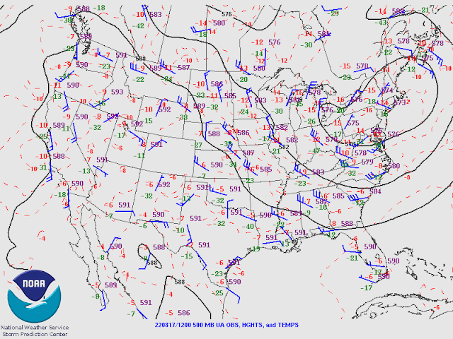
The center of the TD remnant is just south of El Paso and continues to move slowly to the WNW. It is part of a broad IT which stretches further south and is responsible for the considerable morning activity over Sonora and down to the southern Gulf of California. Mid-level temperatures are very warm, as expected with a tropical remnant, as warm as -3C at Chihuahua City. Tucson is better, at -6C.
SPC's CAPE calculation malfunctioned again. I estimate it to be around 800 J/kg for the Most Unstable CAPE. There is a bit of N to NE steering flow, but it's only about 10 knots, so storms aren't going to move too much, and with PW so high, flash flooding is a risk. There are no significant inversions, so heating should be able to easily get deep convection going.Phoenix is about the same: light winds and some CAPE, but probably not enough for storms there.
As a Gulf Surge continues, PW is very high over much of the southern 1/2 of the state. Dewpoints are again extreme around southwestern Arizona, 78F in Imperial and Yuma.
Initializations
The 9 and 12Z RR were too cloudy over central and northern Arizona. Other than that, all the initializations did well with the clouds and circulation of the TD. The HRRR and perhaps the GFS are the preferred runs today.
Day 1
I'm not sure I've ever seen this much moisture over AZ and NM simultaneously! The surge continues into the afternoon resulting in very high PW values across much of southwestern Arizona. Moisture also increases over far eastern Arizona due to the TD.
The surge is quite deep, visible at 850mb in the wind field. Dewpoints are as high as 17C!
CAPE is extreme for parts of southwestern Arizona, while eastern Arizona, despite high moisture, has minimal CAPE, probably due to warm mid-level temperatures, downsloping low-level easterly flow, and subsidence in advance of the TD. The TD is located around the Chihuahua/Sonoran border this afternoon.
-3 to -4C over southeastern Arizona isn't going to be favorable for deep convection.Areas west of the clouds will at least have a chance for some heating, but it looks like the most favored locations for deep convection will be the high CAPE area.
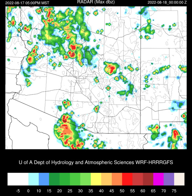
Very little activity is present in SE Arizona by late afternoon. The HRRR runs develop strong storms in central/western Pima County and move them to the SW into Mexico. It's also active north and northwest of Phoenix, where 500mb temperatures are slightly lower.
The WRFGFS run stands out from the others as it's much more active in SE Arizona. It always seems the WRFGFS is too active, and I believe this is the case again today.
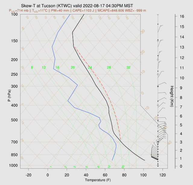
The Skew-T forecast for the late afternoon indicates a high potential for storms as CAPE is around 1100 J/kg, has excellent NE steering flow, and has good low-level shear. The PBL is mixed fairly deeply as well. The only negative is warm air above 500mb.


No comments:
Post a Comment
Note: Only a member of this blog may post a comment.