Previous Forecast
Storms developed over far SE Arizona, moved to the west and impacted the Tucson area after dark. These storms became part of a huge MCS that rampaged across Sonora.
The WRF runs were mostly accurate, including predicting the MCS in Mexico. None were able to continue the MCS activity into the morning hours though, which is likely to cause issues with the day ahead forecast of a major severe weather outbreak west of Phoenix.
Discussion
The center of the 500mb anticyclone continues to be displaced to the east, over Kansas while a big cutoff low spins off the coast of California. 500mb temperatures are more favorable at -6 to -7C. Steering flow is a decent 15 knots from the southeast over southern Arizona and an IT is located south of El Paso. A tropical system is not yet named, moving NW, south of Baja. It looks stronger than a TD, IMO and may pass close enough to the southern Gulf of California to trigger a deep Surge in the next day or two.

The IT is obvious at 300mb and was the main driver of the Sonoran MCS. Southern Arizona and northern Sonora continue to be under favorable upper-level difluence/divergence.
The 12Z Tucson sounding only has 479 J/kg of MLCAPE. Another negative is the strong upper flow, which continues to be in the same direction of the steering flow, resulting in anvils racing out ahead of the storms. The support of the IT may be sufficient to offset these negatives.
There is nothing good to say about Phoenix. CAPE will need to significantly improve for any chance of storms there.
InitializationsThe MCV is near Puerto Penasco and has a fair amount of debris clouds, some showers, and storms over central Arizona. As John Sirlin said on Twitter: "I wonder if that’s enough to play a spoiler role for tomorrow…" This certainly looks to be the case for some of the model runs. The 6Z runs were bad as they had no activity this morning, and very few, or no clouds. 9Z RR was a bit better, but still not enough activity. The 12Z RR was actually quite good, and the issue of excessive deep convection developing shortly after initialization time isn't a problem today. 12Z HRRR was better than 6Z, but still not enough activity. It looks like it's the 12Z WRFRR for today.
Day 1
PW has increased over central and western Arizona as Yuma is now up to 50mm. In the wake of the MCS, PW has decreased for southeastern Arizona as Tucson has dropped to 32mm. PW doesn't change much by early afternoon. Drier easterly downslope flow is present over far SE Arizona.
850mp dewpoint temperatures are a high 13-15C over southcentral and central Arizona. The question of the day is if there is going to be enough heating to overcome the cooling of the lower troposphere due to the MCS.
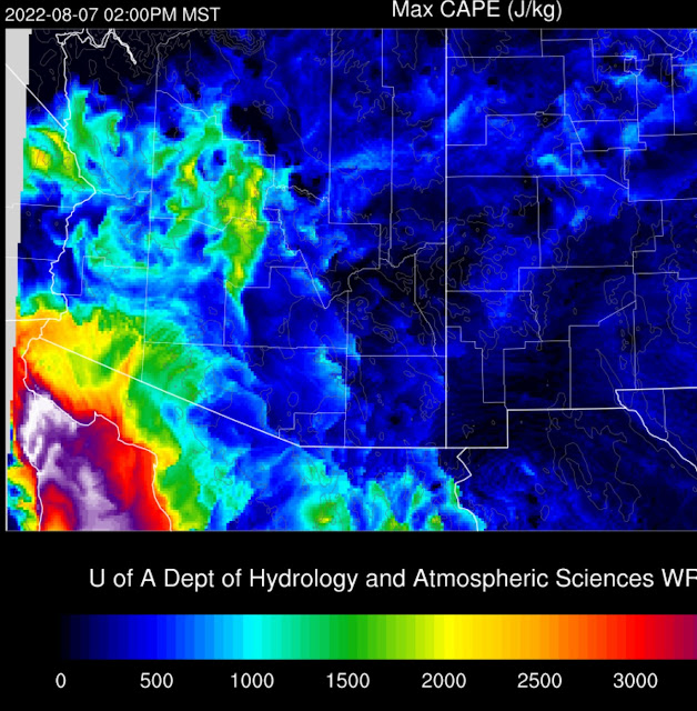
Most of southeastern Arizona has only minimal CAPE, but probably sufficient to support storms over the higher terrain. CAPE significantly improves around the Phoenix area, and it is high by the afternoon.
Both of the 12Z runs develop strong storms north of Phoenix and other storms over the high terrain of southern Arizona.
Tucson is better as CAPE is around 1000 J/kg and only a minimal cap. Mid-level steering flow is quite good as easterly of 20 knots, and the upper-level flow is not as bad previously as its northeasterly flow.
Both 12Z runs have some storms in Tucson, but most of the activity is south.
Only the 12Z WRFHRRR has a decent deep PBL. CAPE is also OK at around 900 J/kg, so some storms might occur.
There is a vast difference in the amount of convection compared to all model runs before the 12Z. 12Z runs hardly have any activity this evening.
9Z RR for comparison.
Day 2
Moisture continues to be impressive from Tucson and to the west. Drier air advection continues over far Southeastern Arizona.
CAPE is impressive for the Phoenix area and southwestern Arizona.
Southern Arizona is active by the late afternoon.
Storms eventually move/develop near Phoenix later in the evening.


No comments:
Post a Comment
Note: Only a member of this blog may post a comment.