Previous Forecast
A major western Arizona precipitation event occurred on the 14-15. The majority of the event occurred in the middle of nowhere.
Discussion
The main story for the next few days will be the old TD that moved onshore over south Texas a few days ago. These tropical systems are always challenging as they don't do much due to widespread clouds restricting heating and warm air at mid-levels, or they do a lot, especially if they interact with a trough. It is moving WNW and is approaching El Paso. There is another cyclonic circulation over northweona, which was responsible for the heavy rain in northern Arizona and southern Utah over the past 24 hours. Heights have come down a lot, but temperatures are quite warm at -6 to -5C.
The end is near! Of the monsoon, that is. The first sign is that the 300mb anticyclone has migrated back to the south, and a trough is now located over the far western Cis is actually a good thing for the lower deserts as the anvils will now be blown away from storm movement. This has been a reoccurring issue for much of the summer for Tucson and Phoenix. It appears there is a broad upper-level cyclonic circulation over central Mexico, extending northward to the TD. This results in some divergence over Sinaloa and Sonora and is probably responsible for the ongoing thunderstorms over the southern Gulf of California. This activity may result in a Gulf Surge over the next day or two.Moisture continues to be more than sufficient for activity. PW is 41mm at Tucson and 43mm at Phoenix. PW is increasing over southwestern Arizona and ranges from 44 to 49mm. Surface data does indicate a Surge is already underway as dewpoints are in the mid to upper 70s for SW AZ and far SE CA. Imperial is 79F! "But it's a dry heat!"
The Tucson sounding has a bit more MLCAPE, around 400J/kg, but is still not that great. Steering flow is mainlaboutherly at around 15 knots; as discussed earlier, upper-level winds are now westerly. There are no significant inversions. Overall, not great, but not bad.
Initializations
It is mos and there are no MCVs spinning about, for once. The variouuns were a bit too cloudy; otherwise, all initializations were accurate. There is quite a bit of GOES-derived CAPE over much of southern Arizona, which is also initialized well.
Day 1
The approaching TD remnant is already causing a problem. Low-level easterly flow and subsidence result in drying over western NM and into eastern Arizona. On the other hand, the surge continues to advect moist air into the rest of the state.
The surge is relatively shallow as it doesn't really show up at 850mb very well. 850mb dewpoints are very high, around 13-15C. Thus, there is a considerable flash flooding risk with storms that manage to form.
CAPE is moderate to high over much of south-central to southwestern Arizona. The question is, how capped is this Gulf Surge airmass?
Model consensus is that storms will develop over the higher terrain this afternoon, along with other storms in western Arizona. By early evening, most runs have strong to isolated severe storms in the Tucson area. The strongest activity seems to remain over the higher terrain of eastern Pima County, which has been the case for much of the season.
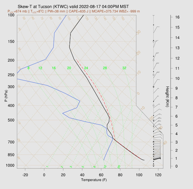
The Skew-T's forecast looks good for Tucson as CAPE becomes relatively high this afternoon. Steering is better; from the SE, the Surge flow kicks in, providing excellent low-level shear, and upper winds are from the northwest. Based on all of this, it looks very active for the Tucson area by late afternoon. Maybe more so than the forecasts are indicating.
As usual, it's hard to say what is happening in Phoenix. Earlier runs had quite a bit of activity later this evening, but the 12Z runs have backed off. The CAPE forecasts range from 800-1200 J/kg, sufficient to support some activity. The PBL is mixed deeply, but there is a subsidence inversion around 500mb. Steering winds are weak at 5-10 knots.
It could be this:
Or this:
Day 2
The TD remnant moves to the Sonora/Chihuahua border by early afternoon, resulting in moist easterly flow over southern NM and into southeastern Arizona, while a weak surge continues for southwestern Arizona.
Very moist air is present over all of the southern 1/2 of Arizona and New Mexico. Unfortunately, strong ESE flow is present over SW NM into SE Arizona, which is rarely favorable for storms due to downsloping flow.
Another big problem is the clouds associated with the TD and the lack of heating. The WRFRR is especially cloudy. It's looking especially grim for precipitation over far southeastern Arizona and SW NM.
Despite very moist air, CAPE is generally less than 1000 J/kg for much of the eastern 1/2 of the state.
All the above negativity translates into very little activity during the afternoon and into the early evening, except for a few storms around the Phoenix area.
The forecast Skew-T tells the sad story for Tucson at least during the afternoon. Minimal CAPE and a strong inversion at 500mb. Flow is mostly unidirectional all the way up, without any shear.
The dividing line between better CAPE and cooler mid-level air is close to Tucson, and by early evening storms are likely to develop just west of town. So, at least parts of Tucson may not get shut out.


No comments:
Post a Comment
Note: Only a member of this blog may post a comment.