Previous Forecast
Wet and wild! The eastern 1/3 of the state received a widespread soaking, but only a few areas had flash flooding accumulations. That was reserved for NM where there were large areas that received over 1". A squall line again moved north to south over western Arizona all the way to Puerto Penasco.
Fortunately, some of the extreme forecasts from the WRFRR didn't verify. A 15Z run had 6" accumulation for Mt Lemmon, but gauge data show "only" 2.8", which was close to one of the clusters of the ensemble forecast of 2.5". All the runs forecast the western Arizona activity well.
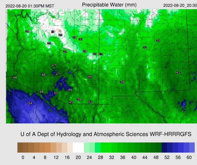
DiscussionThe remnant low-level cyclonic circulation appears to be near Sonora's west coast, not far from Hermosillo. Convection has been firing for much of the night in the general area. A drying trend has begun in western Arizona as PW has decreased to less than 50mm, but that may be temporary as it appears to be post squall line subsidence induced. PW is extremely high elsewhere. For example, Tucson is at 2.02" and looking at the sounding climatology, these are some of the highest amounts ever recorded. According to the GPSMET UofA sensor, PW peaked at 53.7mm overnight, which ties the all-time record from the sounding record.

The morning sounding is saturated all the way up, as would be expected. The CAPE is a skinny tropical profile with almost 1000 J/kg of Mixed Layer CAPE. Winds are poor, with southwesterlies dominating. Low and mid-level winds appear to be temporarily affected by a possible MCV from the western Arizona squall line and will probably go back to southeasterly shortly. Even a little sun should be sufficient to get heavy showers and a few storms going today.

It's about the same situation in Phoenix. Like Tucson, Phoenix also has strong upper-level wiresence of the upper-level trough.
It is a complicated pattern at 250mb with a broad trough over the SW and another closed circulation in Utah. Southern Arizona seems to be in a weak difluent pattern, which isn't as strong as was forecast by some of the runs from yesterday. NM isresultingch resulted in all the rain there over the past 18 hours.
500mb is even more of a mess. The UT closed low has -7 to -9C associated with it, bueems to be stuck and hasn't moved much since yesterday. Who knows what is going on in Arizona and Sonora, especially as the Guaymas sounding is missing at 500mb. However, data is present at 850mb, indicating the old TD might be going strong as there are 30-knot southerly winds! 25 knots at 925mb. It's hy for sure if these winds are correct as there was deep convection near the sounding location.
InitializaevidentIt's clear in far western Arizona, so GOES CAPE is working there, and it's very high, above 1000 J/kg. For some reason, GOES-derived CAPE, at least here in the SW, always is less than sounding derived CAPE. Clouds and showers were initialized well by all initializations. The various RR runs had too much morning activity in SE Arizona. The 6Z HRRR and GFS were much better. The 12Z HRRR also had a bit too much. A weak cyclonic circulation is visible in the loop just north of Tucson and is responsible for the ongoing shower activity. This circulation was generally initialized too far to the northeast, but the 12Z HRRR was better. All were able to initialize the remnant low well. I'm presently surprised by how well everything looks, considering the complexity. The only major issue is with the RR series having too much morning activity, which may not even be a serious error.
Day 1
The GofC low drifts slowly to the north and begins to weaken. It also has started to advect some dry air into the circulation from the Pacific, at least at 850mb. Dewpoints are still 15 to 17C from central Arizona to New Mexico.
PW remains very high, with the wettest air shifting to the east. Tucson remains around 50mm.
CAPE continues to be marginal for storms for much of southeastern and eastern Arizona but is moderate to high from Phoenix westward. It looks like another western/central Arizona rimshot this evening.
Upper-level difluence/divergence is minimal and only over southeastern Arizona and into NM as the jet moves out. However, a trough remains over California. The UT closed low doesn't move much.
The UT low advects cooler air at 500mb into northern Arizona, which offsets the lack of upper-level support.
Heavy showers and maybe a few thunderstorms reform during the afternoon hours across southeastern Arizona. Stronger storms develop near the Phoenix area and over northwestern Arizona by late afternoon.
It looks very favorable for big storms in and around Phoenix this evening. Steering flow is excellent, from the NE at 20 knots, with some low-level shear and upper-level winds in the opposite direction of steering. CAPE is high, at 1800 J/kg.
All model runs have another squall line-like feature moving across Phoenix and west this evening.
Some areas of severe winds are likely, mainly due to wet microbursts. Frequent lightning and flash flooding are also likely.
Some runs have 2" or more of rainfall in and around Phoenix. Some areas of southeastern Arizona also see excessive amounts of rain into tomorrow morning.
Day 2
The remnant low moves slowly north and is over the northern Gulf of California by morning. This location results in continued southerly flow over a wide area of southeastern Arizona.
The mid-level circulation decouples and starts to move into far southern Arizona.
This low is responsible for continuing the heavy showers and maybe some thunder into the morning hours tomorrow.
Activity decreases for southeastern Arizona, but with daytime heating and some CAPE, another(!) squall line feature develops NW of Phoenix. The lower deserts have finally been worked over enough as the storms die as they move towards Yuma.


No comments:
Post a Comment
Note: Only a member of this blog may post a comment.