Previous Forecast
Severe storms rampaged across western Arizona again, while the Phoenix and Tucson area only saw a little activity. The forecasts had a lot of uncertainty for the urban areas as some had limited activity, and some had a lot. SE Arizona was much more active than it's been recently, and in my neck of the woods, Portal picked up over 3" of rain. Most runs missed Cochise County activity, but not all! If I continue making these forecasts next year, one of my goals is a better display of the suite of morning runs, similar to what the NWS does with their HREF.

Discussion
It is a complicated flow regime over the western NA at 12Z with a high amplitude ridge over BC and stretches nearly to the north pole. Another cutoff low is trapped in the ridge over gton. Arizona has quite cool temperatures over northern Arizona at -8C, but southern Arizona is warmer at -6C. A weak trough is located near the NM Bootheel or south in Chihuahua and seems rible for the clouds there.
A weak surge is underway in southwestern Arizona as surface dewpoints are again in the mid-70s, and PW rebounded into the low 50s despite the strong activity in the area last night. This is interesting as yesterday's model forecasts had drying and less CAPE in the wake of the activity. Despite not having much activity, Phoenix looks worked over, with only 175 J/kg of MLCAPE. Steering flow is good with 10 to 20 knot ENE flow, but there is no low-level shear.
I've been using
ACARS data quite a bit this season to watch the evolution of the vertical profile at Phoenix. Here's a 1210Z pprettye; you can see it's quite accurate. However, the winds are always weaker than observed. Maybe they are in m/s?
Tucson doesn't look any better. Zero CAPE and no low-level shear. Westerlies have made it to almost 500mb.
It's also dried out as PW is in the mid-30s. It's not looking good for Tucson unless there is an increase in moisture/CAPE.
Initializations
Cloud initializations were mostly accurate except for the RR runs, as coverage was too much over western Arizona and a few showers/storms. However, these errors shouldn't matter for central/eastern Arizona. The weak IT south of the bootheel is mostly initialized OK, except for the GFS, which didn't have the circulation. The WRFHRRR and RR have better initializations. Generally, the WRFGFS has been too active this year, just like the regular GFS are for the medium term.
The weak surge continues into the afternoon but isn't strong enough to reverse the flow from easterly, which is in place over much of eastern and central Arizona. PW remains at high to very high levels.
850mb dewpoints are back to extreme levels of 15-17C for much of central and western Arizona. They are even high in the southeasterly flow in southeastern AZ and SW NM. This is one of the few cases where SE flow doesn't result in drying.
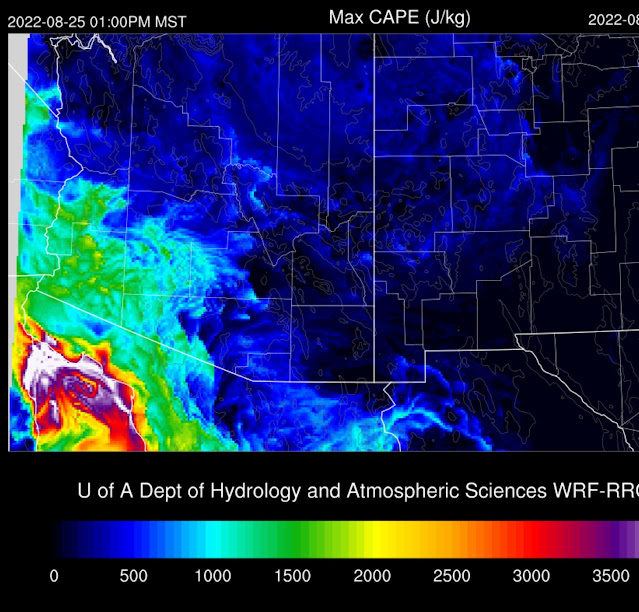
It's the same old story with CAPE as much of the eastern 1/2 of the state is below 1000 J/kg, which is enough for medium and high elevations but not good for lower elevations. CAPE continues to be good for southrelativelyrn Arizona. CAPE is quite high for the Grand Canyon region, so maybe some good storms there?
The high terrain of the Rim to the White Mountains is quite active by mid-afternoon, while the rest of the state is quiet.
Heating results in some CAPE at Tucson, but there is a subsidence inversion at 500mb. Steering is OK, but there is no low-level shear. The PBL is mixed well, but with the lack of CAPE, any storms that form will be weak.
Much the same story in Phoenix. The PBL is mixed deeply by late afternoon, but CAPE is insufficient to support big storms.
Some weak activity is expected in the Phoenix area as storms from the north and east move into the valley this evening.
It looks like another big night for far western Arizona. Casino flooder in Vegas?
Day 2
Moisture decreases somewhat as 850mb dewpoints are from 14-16C. They are still very high, though.
CAPE is also a little lower but still sufficient for high terrain storms. Despite OK CAPE, western Arizona's string of storms is probably over.
Only scattered, mainly weak storms are expected tomorrow.


No comments:
Post a Comment
Note: Only a member of this blog may post a comment.