Previous Forecast
It was a wild night just west of Tucson as training strong to severe storms resulted in heavy rain with some areas over 4". Gauge data indicated 2.17 at Three Points and 3.15 at highway 286/Altar wash. Tucson mainly received light precipitation, and Phoenix wly quiet, despite a 0Z sounding with almost 1700 J/kg of MLCAPE.


Discussion
Visible satellite imagery indicates the remnant low is just south of Cochise County. The 500mb map has a broad area of cyclonic circulation over NW Mexico, southeastern AZ, and SW NM, but temperatures are still a warm -6 to -4C. A broad trough has amplified the 500mb ridge (or vice versa) over the western CONUS. There is a cutoff low near Reno, which may play a role in our weather in a few days.


Tucson is mostly the same, but a couple of inversions may make deep convection difficult, plus CAPE is marginal at 469 J/kg.

Initializations
It is not as cloudy as it could be, considering the amounts of moisture around. Cloud initializations are mostly accurate, but the 12Z RR clouds are too thick and widespread, especially in western Arizona. The initial position,, of the low is generally accurate. Most runs should perform well, except for the 12Z WRFRR which will probably have issues in central and western Arizona.

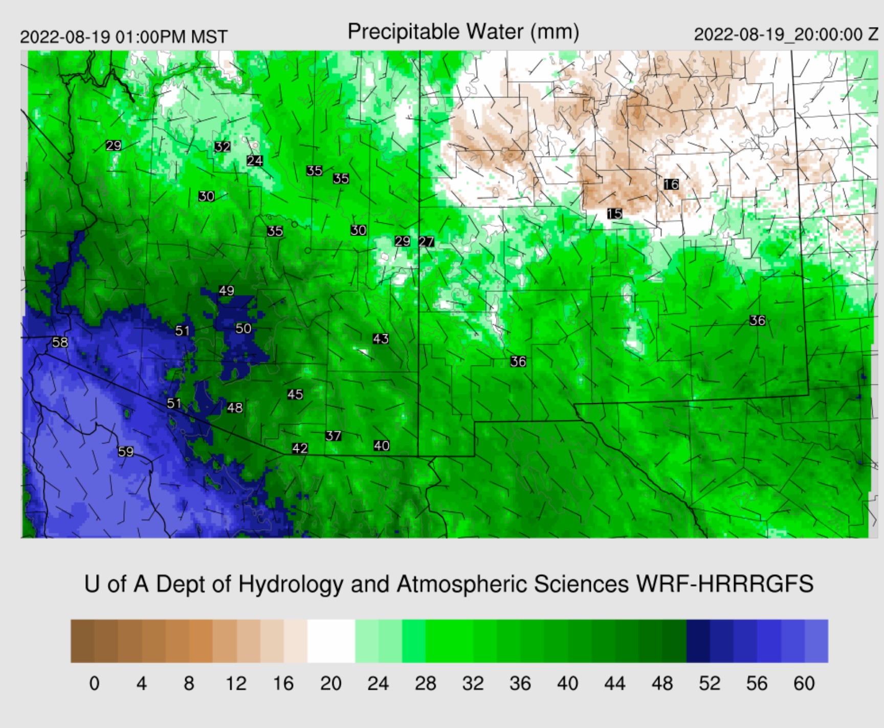
Day 1
The firehose/Gulf Surge continues into the afternoon, keeping PW at extreme levels. The low-level easterly flow will weaken somewhat but still may keep convection to a minimum east of Tucson, especially considering all the clouds present.

850mb is interesting as it appears the old TD low-level circulation is centered over Nogales. Dewpoint temperatures continue to be high at 15 to 16C.

CAPE continues to be marginaof the eastern 1/3 of the state. 250mb indicates a little divergence/difluence is present over SE Arizona, but who knows if it will be sufficient to force anything more than brief heavy showers. CAPE is much more favorable in central and western Arizona, which is high to extreme. However, western Arizona is strongly capped, as seen on the 14Z Yuma sounding. MUCAPE is 2755 J/kg, so the below forecast of 2-3000 J/kg seems reasonable.


It takes some time to get storms going; by late afternoon, much of southern and southeastern Arizona is still quiet. All the runs are nearly identical to this forecast.

While Tucson has a fair amount of CAPE, around 1000 J/kg, there appears to be a bit of dry air entrainment just above the mixed layer and a weak inversion. The vertical wind profile has no low-level shear, but steering flow is quite strong from the ENE. Another subsidence inversion is present just above 500mb. All these things seem to be conspiring against any deep convection.

During the evening, activity starts to pick up around the Phoenix area as steering flow is favorable for moving the existing storms into the valley. Every run has activity n or nar Phoenix, so something will likely happen there. The 12ZHRRR, below, is the least active of all the runs.

The forecast Skew-T looks pretty good, with over 1500 J/kg, some low-level shear, 10 knots of easterly steering flow, anvil-level winds from the opposite direction, and a deeply mixed PBL. There is a cap, but with some outflow interactions, this cap can be broken.

Many runs develop widespread strong to severe storms for southwestern Arizona late this evening. It's not often I talk about Yuma, but the forecast Skew-T indicates this is a real possability as the cap weakens by early evening. CAPE is extremely high, nearly 3000 J/kg, and PW is 56mm. Storms that manage to break the cap will be severe and produce extreme rainfall.

The most conservative run (like Phoenix) is the 12Z WRFHRRR, and it has storms for parts of SW Arisignificantlater this evening.

The 9Z WRFRR (and 6Z WRFHRR/GFS) forecasts a major severe weather and flash flooding event. We'll see later this morning if the 15Z WRFRR and/or the WRFHRRR confirm this forecast.

Some runs have areas of 4-6" of rain in SW Arizona.

Day 2
There is no reason to try to forecast any details for tomorrow. The general outlook is we remain in the soup, with PW again from 50 to 58mm over the southwestern deserts. SE low-level flow continues over southeastern Arizona, which will probably continue to suppress activity there.
CAPE is forecast to be a bit higher for eastern and southeastern Arizona, so there may be more activity after all. With steering still being easterly, perhaps the Tucson and Phoenix areas will see more activity as there will be more upstream storms. CAPE would certainly support big storms for Pima and Pinal Counties.

No comments:
Post a Comment
Note: Only a member of this blog may post a comment.