Previous Forecast
It was an active evening for Phoenix and much of southwestern Arizona. There were some severe reports, plus flash flooding.
The WRFRR and somewhat surprising, as it's not been doing very well this summer, and the WRFGFS had the best forecasts.
Something very unusual is going on over the central Gulf of California. It looks like the old tropical system is trying to spin up again. An obvious large low-level circulation centered over the Gulf and intense deep convection located over the center of the circulation. Tropical systems can maintain themselves as they move up the Gulf, but I've never seen one regenerate!

The 300mb map has a trough moving into western Arizona, supporting any storms that get going today, tonight, and tomorrow. Due to the slow-moving trough, this will likely be a long-duration heavy rain event.
It is wet out there! PW is about as high as it gets at Tucson, at nearly 50mm. MLCAPE is very high, over 1400 J/kg. Steering winds are pretty good, out of the east at 10 to 20 knots. However, a notable inversion around 600mb may keep a lid on deep convection. It won't take much to get things going, though, as the LFC is only 800mb. Another issue is that on days like this, a little heating sets storms off early over nearby mountains and clouding over the valleys, so heating is cut off, and nothing happens in the lower elevations. On the other hand, with the presence of the upper trough, there may be enough support for deep convection. After saying all of the above, my guess is 1400 J/kg of CAPE will win out, and Tucson should be active.
Phoenix doesn't look as favorable as MLCAPE is only 800 J/kg. Steering flow is also poor.
Initializations
Clouds, clouds, and more clouds. Shockley, all initializations were accurate with their depiction of all the clouds. They also had the weak morning showers initialized well. Even the RR didn't have too much activity like it sometimes has. They all had the low-level circulation accurately initialized, just south of Isla Tiberon. Despite all the challenges, the initializations look good, and no clear favorite exists.
Day 1
The potential spinup or, at minimum, continuing the TD's circulation and its location will majorly impact Arizona's weather over the next few days. The surge event has ceased, but historic amounts of PW remain over the state.
850mb is especially interesting as the cyclonic circulation is well established, resulting in extreme amounts of moisture advecting into the state, especially the southeast and southcentral. It's a rare event to see 18C dewpoints at 850.
Despite all the moisture in SE Arizona, CAPE is still marginal but slightly better than the past few days. It's much better from Tucson to Phoenix and westward.
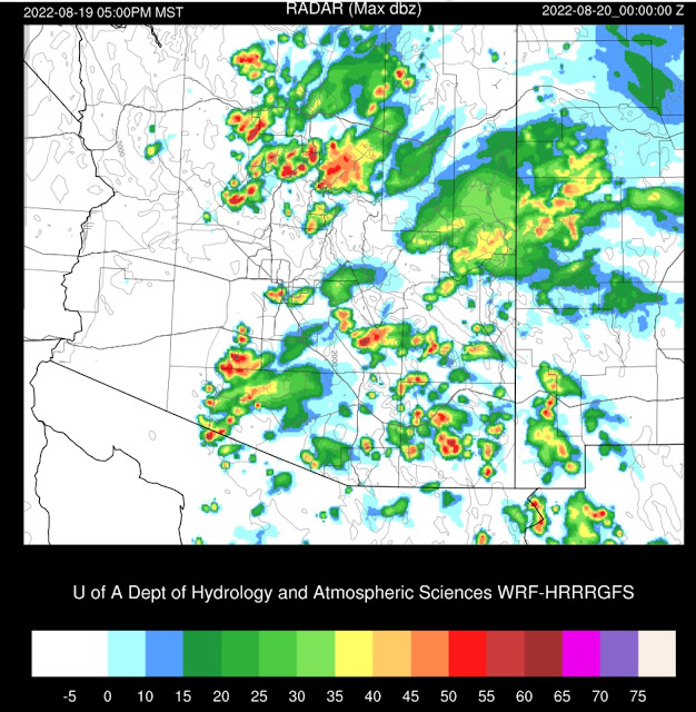
Despite all the clouds, by early afternoon, all runs are similar in developing scattered storms over much of the eastern 1/2 of the state. Tall skinny CAPE profiles, weak steering, and a warm rain process will result in storms producing heavy rain. Another round of mid-day flash flooding near Flagstaff.
Heavy showers and thunderstorms continue to expand to the west during the late afternoon hours while precipitation continues in eastern Arizona.
It appears east-central Arizona will receive a long period of heavy precipitation due to orographic enhanced upslope flow and southeasterly and eventually southerly flow across eastern Arizona and western NM. This is in combination with the support of the upper trough.
Many runs consolidate the scattered storms north of Phoenix into a tropical squall line, which moves south during the evening hours. Some have it moving into Phoenix, but others, just to the west. As Phoenix got worked over last night, I'll go with the westernmost forecast.
The situation overnight for east-central and west-central NM becomes more serious as the flow becomes more southerly, thus already enhancing the orographic enhancement.
This isn't the only location at risk, as many runs continue storms and heavy rain over south-central Arizona into the early morning, forced by the upper trough.
Day 2
All the runs maintain the low/mid-level cyclonic circulation, and some intensify it, like the WRFRR. At 5am, the location hasn't changed much, but there is a broad area of 20-knot winds on the east side. I've used the firehose analogy earlier this season, but this is more like a raging river!
The 250mb trough continues to provide some upper-level divergence/difluence, especially over southeastern Arizona into western NM. (5am forecast)
Heavy rain and thunderstorms continue to reform under this area of upper-level support. The runs are slightly different with the location, as the WRFHRRR is a bit farther to the south than the WRFRR(below).
48-hour accumulated precipitation. Insanity!


No comments:
Post a Comment
Note: Only a member of this blog may post a comment.