Previous Forecast
Tucson finally saw a widespread storm event as a severe storm developed over the Catalina Mountains and drifted south over the city. Unfortunately, the WRF runs kept deep convection over the mountains, but the forecasts on Wednesday for Friday had storms in the city. MCVs are always tricky as they can suppress convection near the core of clouds and mid-level warming or enhance convection along the edges where it's clear, like in Tucson yesterday. The MCV was positioned to provide enough mid-level flow to move the storms into the city. Looking back at the WRF runs, they did not have a strong enough circulation. Another issue was PW, as WRF didn't forecast the moisture convergence seen on the GPSIPW trace. The cloud camera movie of the event, from the HAS cloud camera, was fantastic.


Other than missing the storms moving into Tucson, the runs were pretty good, including the test configuration of the WRFHRRR (labeled as "missing"). The WRFHRRR will use the new configuration for operational runs.
Discussion
My first look at the morning 12Z data didn't give me much hope for today as there were a lot of negatives with the morning sounding from Tucson. First, there was no CAPE. Another was the inversion at 500mb, where temperatures have increased to -4C. The positives are that it's still quite moist, with PW around 35mm, and there is quite a bit of southeasterly steering flow at 700-500mb. So, for a more active day, something has to change.
The PW tract has slowly increased over the past 12 hours at Tucson and Amado, indicating moisture advection. It's also quite moist to the east of Tucson, with 40mm at Safford. If this continues, CAPE will also increase, and as it's clear around Tucson, heating should also be good.
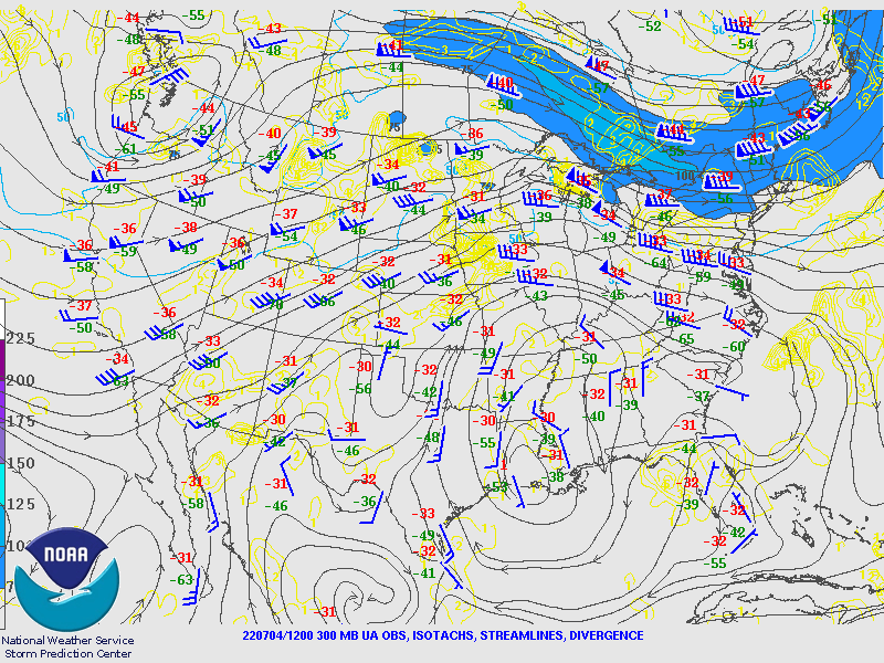
There is a large tropical upper-tropospheric trough off the west coast of southern Baja, resulting in an area of upper divergence NW Mexico and into southern Arizona. This feature should help enhance afternoon deep convection.
Another trough is over the NW CONUS resulting in mainly SW mid-level flow over most of Arizona. As mentioned earlier, 500mb temperatures have warmed into the -4 to -5C range, which is a disturbing development, as so far this season, temperatures have been in the -7 to -8C range.
Initializations
The initializations of clouds are really struggling. The RR and GFS had too much over Tucson to Phoenix, while the HRRR didn't have any cloud over southeastern Arizona. The HRRR is best for the areas outside of far SE Arizona, while the others will be questionable due to all the clouds over southern and central Arizona. Note the worrisome lack of GOES CAPE over all of Arizona. CAPE is present in southern and central Sonora, but it will take some significant advection to get it into southern Arizona by this afternoon.
Day 1
This morning's model runs are remarkably consistent in forecasting strong moist advection over the southern 1/2 of the state into this afternoon. 850mb dewpoints are moderate to high over much of southern Arizona by early afternoon.
This advection results in moderate CAPE over far southern Arizona by afternoon.
Moist advection increases Tucson's PW to around 40mm by mid-afternoon, resulting in ~600J/kg of CAPE. Not great, but better than zero this morning. Winds have some directional shear and good steering flow, but any storm development to the SW of Tucson will result in anvils blowing out ahead of the storms, and we know what that means for Tucson!
Model runs generally agree on developing storms over the higher terrain around Tucson by later in the afternoon. After that, they are all over the place. Some have strong to perhaps severe storms in or near Tucson.
Others have little or no activity. The HRRR develops deep convection around the Tucson area, but anvils blow across and shut down Tucson proper.
Moisture advection continues over much of southern Arizona into the evening, increasing CAPE and favorable 850mb dewpoints for the Phoenix area.
By early evening, some runs have nearly 800 J/kg around the Phoenix area, which is just enough to support some storms. If things work out right and the Tucson storms can propagate, Phoenix has a chance for some evening activity.
It's a low chance, but a few runs develop activity this evening.
Day 2
Much drier air begins to advect into the state, resulting in minimal activity.


No comments:
Post a Comment
Note: Only a member of this blog may post a comment.