Previous Forecast
It was very active for much of southeastern Arizona and northeastern Sonora. Another MCS formed over northeastern Sonora last night. It's been amazing to see these every night. Storms moved right up to Tucson, but as some of the WRF runs forecast, they pooped out as they entered the valley.
The WRF runs were generally accurate during the day and into the early evening. Precipitation amounts were too low, especially the HRRR and RR. All runs missed most/all of the early morning activity around the Phoenix area.
Discussion
Not too much change in the general pattern. The 500mb anticyclone center has drifted a little to the north, resulting in a slightly stronger mid-level flow over southern Arizona. It's now pretty warm with temperatures from -6 to -5C, but the warming has been offset by an increase in moisture. Tucson is at 40mm and Phoenix (with the morning activity) is over 50mm! Of interest today is the IT located over the Big Bend.
Phoenix is in the same boat, or worse, as it's still completely overcast with dying storms to the southwest. At least it's cleared up in Tucson.
Initializations
It's going to be quite a challenge. There must be an MCV embedded in all those clouds around Phoenix, but I can't see any circulation. There appears to be one from the Sonoran MCS, just southwest of Nogales. The 6Z HRRR wasn't too bad but was too clear around Phoenix. The 6Z GFS was bad as it had hardly any clouds. The 9 and 12Z RR was pretty good, but it had the clouds and showers to the west of Phoenix, resulting in too clear skies there, as was the 12Z HRRR. All did well initializing the Sonoran MCV. Model accuracy should be OK for southeastern Arizona but might be too active for Phoenix, depending on how quickly morning clouds and showers move out.
Day 1
The Surge continues into the early afternoon, producing the highest PW of the year. PW is nearly 50mm over parts of southwestern Arizona.
The 850mb southeasterly flow and moist advection are impressive. Dewpoints are a favorable 10 to 13C. The risk for flash flooding is significant, that is, if storms manage to develop. Dewpoints are especially high right along the Rim.
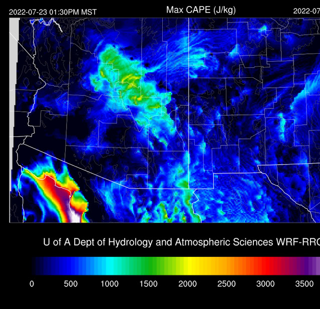
What was looking like a significant severe outbreak for SE Arizona and Tucson looks much less likely this morning as CAPE isn't nearly as high as was forecast. On the other hand, CAPE is very high in the area of elevated 850mb dewpoints. This big change isn't surprising as forecasting even a day ahead can be extremely challenging, especially in complex situations.
With only 900 CAPE, it's much less likely for severe weather, but it's still sufficient for storms. The situation looks similar to yesterday as upper flow is still going to advect anvils out in front of storms.
There is very little agreement between any of the runs today. Some runs, which looked likely, develop widespread strong/severe storms along the Rim and up north of Flagstaff.
Despite clear skies, it took quite a while to get anything going in southern Arizona due to all the activity there yesterday. Widespread, intense storms continue over the higher elevations of northern Arizona.
An area of storms could move through Tucson later in the evening. Confidence in what actually happens here is low. It could be earlier in the evening, or maybe nothing at all.
Phoenix has quite a bit of CAPE by late afternoon and a favorable wind profile. However, there is a cap at the top of the mixed layer. It will take a pretty good OFB to kick off storms there, which at this point, looks unlikely.
Again, the runs are all over the place, with no clear solution. The middle of the road says the Tucson storms move down I-10 later this evening but die out as they move into the Phoenix area.
Day 2
Moisture certainly isn't going to be a problem tomorrow as the Gulf Surge continues to advect moisture into Arizona.
CAPE is impressive over much of the state, at or above 1500 J/kg.
The upper anticyclone shifts far to the NE, and a weak trough is present over NW Mexico, putting Arizona in a favorable situation with significant upper divergence.
In addition, many runs have a mid-level IT or MCV located just to the south of Nogales. Let me give the Magic 8-Ball a shake..... "Signs point to yes."

It's difficult to say precisely when and where storms develop. The WRFHRRR initiates storms early over the higher terrain of far southern Arizona, near the IT.
Storms develop later in the afternoon over the higher terrain of much of eastern Arizona.
By late evening, storms move into the Phoenix area. Predictability in this regime in the day ahead is questionable, so we'll just have to wait and see what the model has to say tomorrow.


No comments:
Post a Comment
Note: Only a member of this blog may post a comment.