Previous Forecast
I wanted to mention the big miss from the 17th, where almost none of the morning model runs, including the HRRR, were able to forecast the massive outbreak of severe weather in and around Phoenix. Only the 18Z WRFRR had any thunderstorms, and at that, they died as they moved into the Phoenix area. It wasn't like the runs were missing CAPE or PW as they had 1000-1500 at Phoenix. As Dan Henz pointed out, the cluster became an MCS, thus forcing additional development across Phoenix. Unfortunately, the bust happened with the most significant severe weather day in some time. This reinforces the point to not always rely on the deep convection forecast of the model but to look at the big picture, like the model Skew-T forecast. I know when I looked at the below plot, I did hear a little voice in the back of my head saying...."what if"?
Discussion
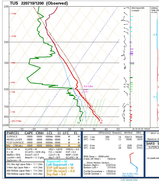
The strong 500mb anticyclone continues over the Four Corners region resulting in mainly E to SE steering flow. Temperatures are moderate at around -7C from Tucson to El Paso. Unfortunately, all of Mexico is missing. Multiple MCSs rampaged across Sonora overnight, and deep convection continues over Baja and southwest of Puerto Penasco. Part of the reason is the mid to upper-level inverted trough, which has moved into far northern Sinaloa. It's too far south to have any impact on Arizona. An outflow-induced Gulf Surge has not yet begun at Yuma, but it should start shortly.
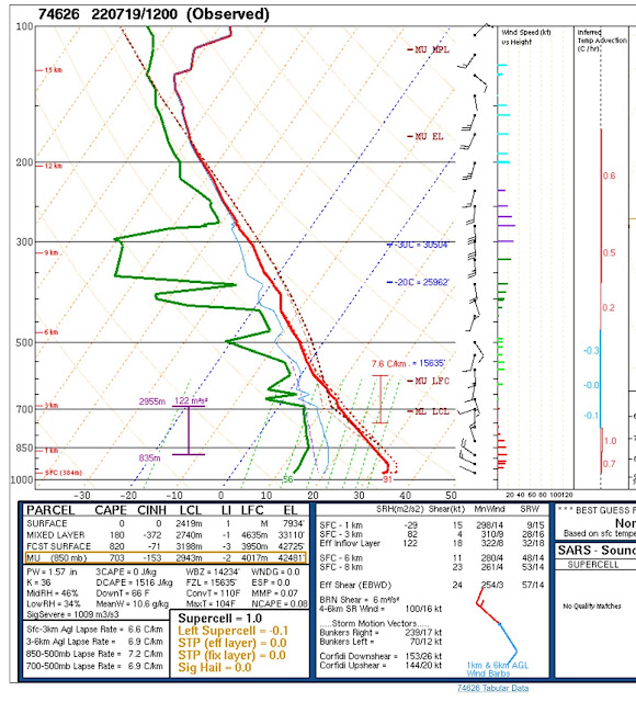
PW is still pretty high over much of southern Arizona, around 35mm at Tucson to as high as 43mm at Organ Pipe. GOES-derived CAPE was observed from far SE Arizona to Lake Meade. Tucson appears to have around 700 J/kg. The vertical wind profile looks quite good as well, as the lowest levels are northwesterly, mid-levels at 15-30 knots, so there is quite a bit of shear, and upper flow of mainly southerly, thus anvils will move 90 degrees from the storm motion. One negative is the strong subsidence inversion just above 500mb.
The story isn't as good for Phoenix as CAPE is limited, and the wind profile is mainly southerly except near the surface.Initializations
The activity in Sonora has resulted in widespread thin cirrus over the state. These clouds shouldn't restrict heating very much. An area of storms is approaching Puerto Penasco and must be associated with an MCV, but it's hard to see because of all the convection. The 6Z runs do not have any activity with the MCV, nor do they have any thin clouds. However, neither should matter much as the MCV is moving away and the existing clouds are thin and dissipating. Generally, initializations look accurate for Arizona.
Day 1
The surge eventually kicks in, and by early afternoon, it is well established over much of the state. In fact, it's managed to advect moisture all the way into SW New Mexico, and for the time being, the dry air advection for the east is over.
The surge is also well established at 850mb. Dewpoints continue to support deep conviction as they are around 11-13C. I've noticed, at least so far this season, there haven't been any days where the dewpoints are in the widespread 13-15C range, as in previous years. Dewpoint in this range results in much heavier precipitation and more flash flooding.
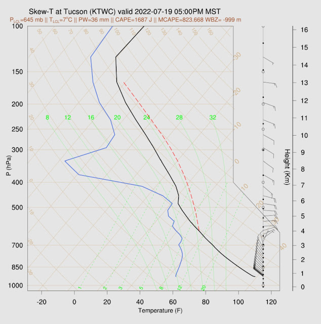
Tucson has some of the highest CAPE of the season, at around 1600 J/kg. However, the mixed layer is relatively shallow, so deep convection will require some outflows. Some runs have a significant cap at the top of the mixed layer. I do hear the little voice: "What about all the CAPE? What about the shear?"
Strong storms develop over far southeastern Arizona by mid-afternoon hours and generally move to the WSW.
The model runs diverge here as some have strong to isolated severe storms in Tucson by this evening, while others had storms dissipating as they move into the valley. For example, the 9Z RR vs. the 12Z RR. Hopefully, the later runs this morning will shed some more light.
Well, that was quite the improvement over the Phoenix 12Z Skew-T! 1900 J/kg and a better vertical wind profile. The mixed layer also becomes fairly deep this evening, but a weak inversion is present and going to be a significant problem. The surge is too much of a good thing as the mixed layer is too cool.


No comments:
Post a Comment
Note: Only a member of this blog may post a comment.