Previous Forecast
There was a lot of activity for the state in the last 24 hours. Heavy rain fell alonRim, especially heavy around Flagstaff, where there was quite a bit of flooding. It was quiet all afternoon and into the early evening for the rest of the state, but storms started to pop across southeastern AZ and have continued into this morning as a little MCS.
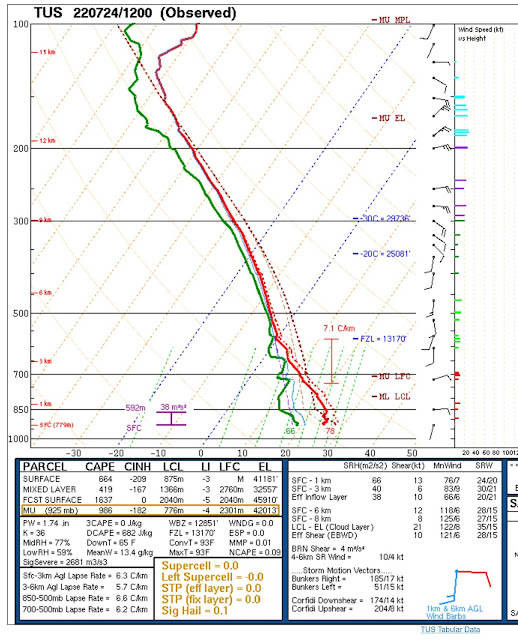
As expected, there wasn't any accurate run, especially in the lower elevations. Dome of the runs did OK along the Rim and Flagstaff.The 500mb anticyclone center is sprawled out from NM to OK, resulting in mainly S to SE flow over Arizona. A more easterly component would be better for steering storms from the higher terrain. Heights have come down about 60m compared to a few days ago, and temperatures are around -6 to -7C, which isn't too bad.
The upper IT isn't as obvious, but it's still there, from about El Paso and south, providing some difluence/divergence over Sonora and southern Arizona. WV imagery is interesting as the MCS is on the nose of a dry slot over southern NM and SE Arizona.
No wonder the MCS has continued over central Arizona this morning as there is a lot of elevated CAPE. Despite heights coming down, there is still a subsidence inversion above 500mb.Initializations
I'm dreading this part as it's such a complicated situation. Dread is well placed as no initialization is accurate. They range from terrible (all 6Z), to not as terrible, 9 and 12Z RR, to least bad, 12Z HRRR. The 12Z HRRR at least had the MCS, but the cloud extent was not nearly enough, and the WRFHRRR killed off the MCS by 15Z. In real life, it's still going. The MCS is likely to leave behind a large area of rain-cooled/stabilized air, so afternoon and evening deep convection are unlikely for those areas. My guess is the more recent model runs may perform ok over northern and eastern Arizona.
As the earlier initializations havestruggled, I've waited for the 15Z runs to start. The RR looks pretty good as it initialized the MCS and associated clouds, so perhaps it will be somewhat accurate.
Day 1
Over the past week, the main Surge mechanism has been outflow induced from Sonoran MCSs. As there wasn't much activity there last night, and a strong surge is ongoing, I looked to the south and the surge extent covers the length of the GofC. It doesn't appear to be the usual mechanism of a tropical disturbance near the mouth of the gulf, but instead, a low-level cyclonic circulation west of BCS.
The resulting surge is very moist and deep. PW continues to slowly increase and is around 50mm in the Phoenix area.
850mb dewpoint temperatures are in the heavy rain/flash flooding category of 14 to 16C.
The early afternoon CAPE forecast by the 12Z WRFHRRR looks pretty accurate when comparing it to GOES CAPE. The 12Z WRFRR wasn't too bad either, so perhaps these two runs will do an OK job. Flagstaff and far SE Arizona areas look like the favored locations today.
The HRRR and RR develop strong storms around the Tucson area during the afternoon hours. Other strong storms are present across northern Arizona.
Scattered storms continue across SE Arizona while a line of strong/severe storms moves over east-central Arizona. Confidence is low as all morning runs have vastly different solutions.
For example, the 12Z WRFHRRR, which wasn't the worst initialization, has strong/severe storms moving towards the Phoenix area this evening. I don't think this will happen due to the modified airmass in central Arizona.
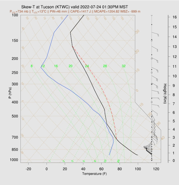
Based on the Skew-T, it sure looks like strong storms are in store for Tucson this afternoon. PBL is mixed deeply (for today), and a lot of CAPE. Steering flow is also quite good, but anvils could be a problem. With better steering flow compared to the 12Z sounding, it looks like the "too wet to rain" scenario is unlikely as storms will move off the higher terrain.
Even if storms get near Phoenix, the forecast is for a strong cap, and storms die out as they approach. It's going to be impossible to break through without multiple outflow boundary intersections.
I almost forgot to include the QPF. Lots of rain in some areas of the state.
Day 2
The surge is forecast to continue tomorrow. PW remains very high for all areas of the state.
The strange little 850mb cyclonic circulation remains off the coast of BCS and continues the deep surge of moisture into Arizona and even SoCal!
CAPE is forecast to be moderate to high over much of central and western Arizona, so this area has the best chance for storms tomorrow afternoon and evening. I'm going to leave it at that as it's not prudent to try and forecast in more detail.


No comments:
Post a Comment
Note: Only a member of this blog may post a comment.