Discussion
A strong gulf surge began due to the outflow from big Sonoran storms last night. Lori Bailey was able to capture images of Blue Jets from one of the storms.

Surface winds are gusting to over 30mph, and dew points have increased into the 75-80 degree range. However, the surge appears quite shallow as PW has only increased to around 32mm at Yuma. The Yuma Proving Grounds soundings have been missing all summer for some strange reason, so I can't verify if this is the case. At Phoenix, moister has increased slightly to 28mm. The sounding exhibits cooling below 850mb and a little more moisture, but MLCAPE remains very low. This results in two significant inversions!

Tucson is better as MLCAPE is a high 1600 J/kg. As with Phoenix, there are multiple inversions to overcome, and the LFC is quite high, at around 650mb. DCAPE is also high, at over 1700 J/kg, so any storm that can get going could produce extremely strong winds.


Initializations
It's clear over the entire state, which was correctly initialized by all. The Texas shortwave also is initialized well. Minimal PW initialization errors were noted, except for the 6Z NAM. There is no clear favorite except not the 6Z NAM.

Day 1
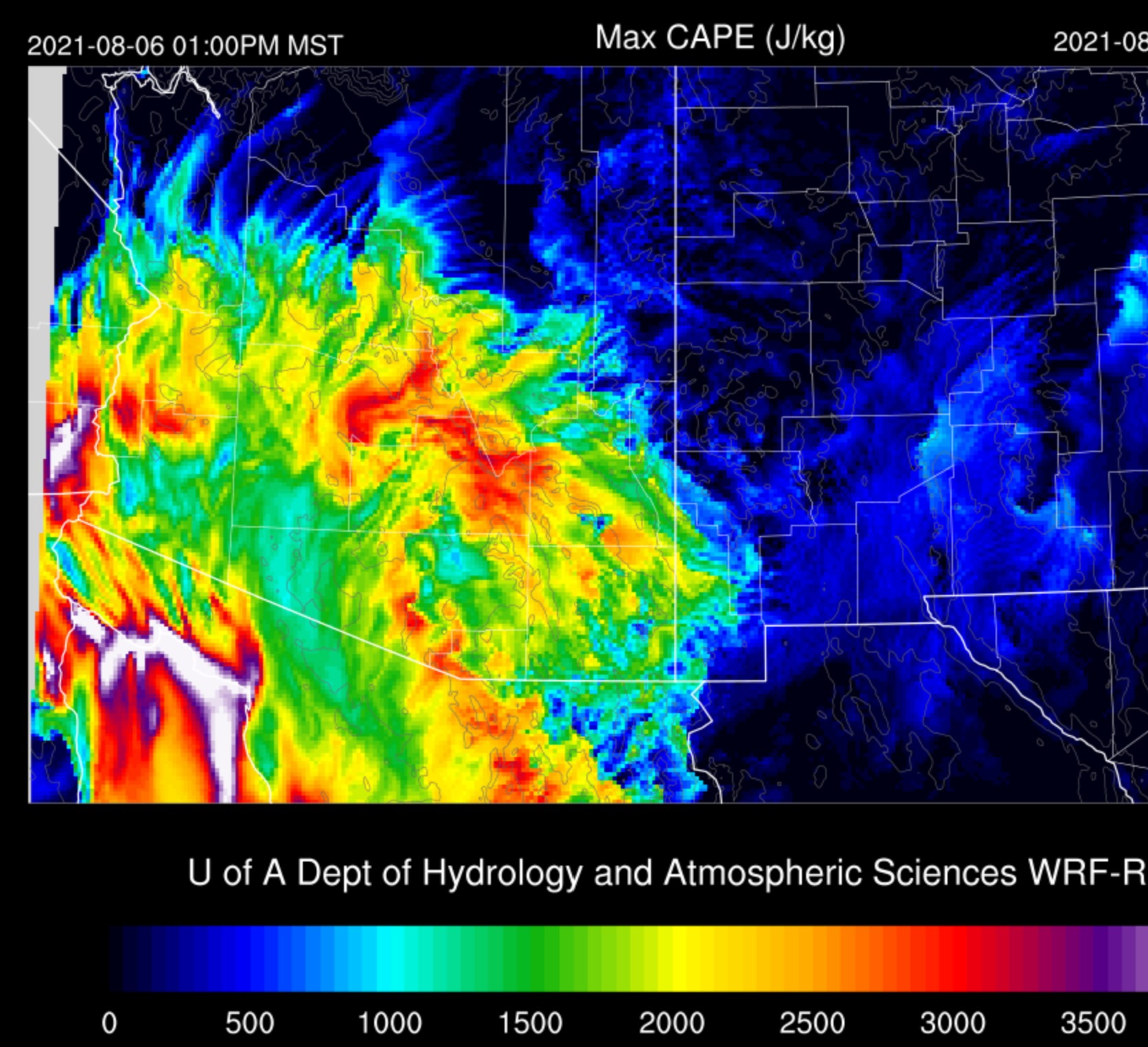
The surge has resulted in high CAPE in far southcentral and southwestern Arizona. I overlayed the COD meso CAPE (surface-based?) on the GOES CAPE, and it certainly looks like central Pima County will be the active area today.


It certainly didn't take the low-level moisture long to return. Afternoon 850mb dew points are a moist 12 to 14C. Also, the surge appears to be quite deep over the coastal plains of Sonora as winds are from the SE at 10 knots. Winds curve around to the SW over Arizona. Thus it's likely there will be some low-level shear available to enhance and organize storms. SE Arizona is again affected by drier air moving in from New Mexico. As a side note, I drove to Douglas, down 80 along the AZ/NM border, and many areas of far SW NM/SE Arizona are still quite brown. Only as I approached Douglas did it get really green.

It's going to be tough for Tucson to get anything going without a significant outflow boundary. While the inversion at the top of the mixed-layer is very weak, the 500mb one is still strong. The vertical wind profile is good, with low-level shear, and good mid-level steering. Anvil-level winds are weaker than the mid-level flow, so anvil shading won't be much of an issue. CAPE also remains quite high, as much as 1400 J/kg.

It looks like far southern Arizona is the place to be for storms! While CAPE isn't as high as earlier in the day, it's still around 1000 J/kg. The same issues with the inversions are present, but with the higher elevations to act as initiation points and the low-level convergence, storms are likely. Also, note the strong (for Arizona) mid-level NE winds at 20 to 25 knots.

All model runs have been consistent in developing strong/severe storms along the border in Santa Cruz and far SE Pima County this afternoon. Look out, Nogales!

Strong outflow winds move into eastern Pima County, and all the WRFRR runs develop scattered strong to severe storms along the outflow boundary in central and eastern Pima County. Note that the gulf surge continues, at least at the surface. Storms make it no farther north.


Day 2
The strong surge continues into tomorrow afternoon and advects very moist air into southcentral Arizona, resulting in incredible 850mb dew points of 15-17C!

This moisture increase results in extremely high CAPE over much of southern Arizona.
WOW! This is about as high as I've ever seen CAPE in Arizona. Now for the buzzkill. There are major issues with developing deep convection. The first is the obvious strong inversion at the top of the mixed layer, and the second is the vertical wind profile is mainly southwesterly, with quite dry air aloft.

The NW CONUS trough moves into the northern Rockies and suppresses the ridge all the way to southeastern Arizona. While far northern Arizona cools slightly, central and southern Arizona remain warm at the mid-levels. The Texas IT appears to end up over Sinaloa, so not anywhere close to Arizona.

It looks like only far eastern/southeastern Arizona manages to break the cap, at least during the afternoon.

By late afternoon, Tucson has a lot of CAPE present as well as strong surge signal in the wind field, providing good low-level shear, but the mid-level steering is light and variable. The PBL is well mixed, and only a minor inversion is present. The potential is there for big storms, and all that is needed is a 1/2 way decent outflow boundary to trigger deep convection.

And that is what happens with some of the runs. Almost a mini Phoenix situation with converging outflow boundaries. 5:30pm WRFRR. Storms don't make it much past Tucson due to the stronger cap.


No comments:
Post a Comment
Note: Only a member of this blog may post a comment.