Previous Forecast
As anticipated, it was a busy night for Phoenix and then the west side of Tucson. The Tucson area didn't get any activity until very late, as the earlier storms in Cochise County didn't make it far into eastern Pima before dying out. Some of the later WRF runs did pick up on this change in timing, like the 18Z WRFRR.
Despite having some issues with timing, the WRF forecasts were generally accurate for precipitation amounts. The 15Z WRFRR looks like it was the best run.
Discussion
The 500mb pattern is dominated by a broad ridge axis, stretching from California to MN. The beginning of the end of the monsoon (for now) is seen as a trough moving onshore over Washington. There is a broad IT located from off the Baja coast back to Missouri, with a closed circulation over southern NM. 500mb temperatures and heights have come down over the past few days, and it's quite cool over Arizona with -7 to -8C.
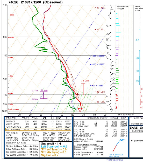
There was no upper-air data from Tucson this morning. The Phoenix sounding, as would be expected, is really worked over, with almost no MLCAPE. Winds are still very favorable, with low-level shear, 20-25 knots in the mid-level, and westerly winds aloft. It's going to be difficult for Phoenix to recover, IMO.
InitializationsClouds, showers, and storms were ongoing over southern and central Arizona this morning. Satellite imagery does indicate a weak MCV over far southern Arizona. All initializations (except the NAM) did a responsible job initializing all the main features.
Day 1
The question of the day is whether the air mass can recover sufficiently and again support evening storms. Normally, this isn't the case. The surge continues to advect extremely moist air into the state. Also, this results in good low-level flow, providing low-level shear for storm propagation.
There is a significant difference between the CAPE forecasts between the 12Z and earlier runs. The earlier runs have much more CAPE by afternoon, like the 6Z WRFRR below.
The 12Z WRFRR hardly has any, which looks to me to be the more likely forecast. It is also very similar to the GOES-derived CAPE from the current time, which has cape mainly in the western 1/3 of the state.
Mid-level temperatures are fairly warm over southern Arizona, at -6 to -5C, which is not helping either. The MCV doesn't move much and is still near the border, while an anticyclone is centered over NW Arizona, resulting in a complicated flow over the state.
A few storms develop over the Rim and White Mountains.
It's bad news for Tucson and Phoenix as little, or no CAPE is forecast by early evening, plus there is a substantial subsidence inversion at 500mb.
This is interesting. CAPE increases over central and southern Arizona during the early morning hours, resulting in some early morning activity around Tucson and Phoenix.
Some runs have significantly more activity than the 12z WRFRR (below).
Day 2
A strong trough dominates the western CONUS, resulting in southwesterly mid-level flow over the state. 500mb temperatures are also quite warm over southern Arizona, resulting in limited activity.
Deep southerly flow is strong and continues to advect very moist air into the state. This looks like a transition event on paper, but I don't think the trough is close enough to provide the needed dynamics.
CAPE is forecast to become moderate to high for much of the state. It's all going to depend on how strong the cap is on top of the mixed layer for the lower elevations. It looks to be quite an active day for eastern Arizona.
Phoenix looks pretty good by later in the afternoon, as CAPE becomes very high. The vertical wind profile has a large directional shear in the lower troposphere but not much above 700mb. There is a weak capping inversion, and if that can be overcome, strong to severe storms would be likely. A big "if," though.
Northeastern Arizona is quite active during the day, but the rest of the state is quiet.
A couple of runs manage to develop a storm or two in the Phoenix area late tomorrow afternoon.


No comments:
Post a Comment
Note: Only a member of this blog may post a comment.