Previous Forecast
It was a down day for the lower deserts. Quite heavy precipitation fell in storms over the eastern 1/3 of the state.
The model runs, including the WRFNAM did an acceptable job with locations but generally didn't have enough heavy precipitation over eastern Arizona. However, they did well predicting the SW NM heavy rain event. It's not shown on the above Q3 plot, but SE NM had widespread 1-3" rain.
Here's the 12Z HRRR from yesterday. It had way too much activity over the western 2/3 of Arizona.
Discussion, Olympic version
I was watching weight lifting with my daughter, and it brought back memories of this guy:
You have to be older to remember him, as it was in the '70s. He was Vasily Alekseyev, the most famous super heavyweight lifter of all time. He set the world record 80 times! It turns out that the Soviet Union gave him a bonus for each world record, so he would increase the record weight each time by only 0.5kg. My daughter's comment wasn't about his records, but "Is that what he wore???"
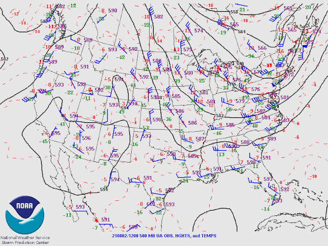
The western CONUS is now dominated by a large and high amplitude ridge, centered somewhere around Wyoming. Arizona is quite convoluted as a trough is trying to move through the center of the ridge. How weird! This results in light NW flow. Temperatures are still moderate at round -6 to -7C.
The trough is better defined at 300mb, and its position places eastern Arizona and NM in an area of difluence/divergence aloft. There is an IT moving onshore south of Brownsville and a jet streak moving down the backside of the eastern CONUS longwave trough. It's possible that some of this trough breaks off and becomes an inverted trough. However, with the present anticyclone centered over NW Mexico, any ITs will move into Mexico unless the 300mb anticyclone moves north again.
The 12Z sounding indicated a moderately moist air mass over Tucson with a PW of around 40mm. MLCAPE was also good at 1000 J/kg. Like yesterday, a significant subsidence inversion is present at 500mb. In fact, it's stronger today, so deep convection is again going to struggle.
Phoenix is even worse looking as CAPE is minimal.
Initializations
It's mostly clear over Arizona and has a moderate amount of moisture over the southern part of the state. Note that GOES PW isn't very close to observed values, as I estimate PW from the image to be around 35mm at Tucson and Phoenix. Worse, the Suominet PW network is nearly dead. Most sites are missing, and Suominet no longer responds to my emails. I can't believe that this essential resource has been allowed to wither on the vine, at least for us non-NOAA users. From the Madis website:
"Since September 1, 2016, GPS-Met data has been provided by Earth
Networks Inc (ENI) and will not be distributed beyond NOAA or be publicly available on the Global Telecommunications System (GTS). Under this contract, the number of sites has been reduced. "
All the initializations were OK in Arizona, but the 9 and 12Z RR were the best in NM. The NAM was the worst. What's left of the PW network indicates that the GFS and RR have only minimal errors. Model performance should be good today, with the RR or GFS being the favorite initializations.
Day 1
Moderate amounts of moisture continue over the southern 1/2 of the state today. Low-level easterly flow is present over southern NM and southeastern Arizona, but it does not advect dry air into Arizona, unlike previous situations.
850mb dew points are quite high over southeastern Arizona and into NW Mexico.
This moist air at 850mb results in moderate to high CAPE over southeastern Arizona, similar to the GOES-derived CAPE.
The morning runs are all quite similar in developing scattered storms over the higher terrain of southeastern Arizona by later in the afternoon. The 12Z WRFRR has quite a bit of activity around the Tucson area.
The early afternoon forecast Skew-T plot for Tucson has a moderate amount of CAPE, but the inversion continues to be strong at 500mb. Steering flow is light, so storms don't move off of the high terrain, and it's unlikely for storms in Tucson proper.
Thunderstorms continue into the evening, and some storms could be strong/severe.
Outflow boundaries may move into south-central Arizona later this evening, and with around 600-1000 J/kg of CAPE, a few storms may pop up.
Day 2
Much drier air moves into the state tomorrow, resulting in little or no activity.


No comments:
Post a Comment
Note: Only a member of this blog may post a comment.