Previous Forecast (from 18 Aug)
Widespread heavy rain occurred to the north and east of Phoenix. Some areas were estimated to of received 6-7". Multiple waves of storms moved through Phoenix, resulting in areas receiving more than an inch. Earlier WRF runs didn't have much/any activity there, but later runs did, but the forecast was still too low.
WRF runs had the right idea, as some runs had 4-5", but the extent of the heavy precipitation was too small, and the runs that did have some activity in Phoenix.
I've recently started running an 18Z RR initialized run, and it's been quite accurate so far. It's much better than the 18Z NAM.
Discussion
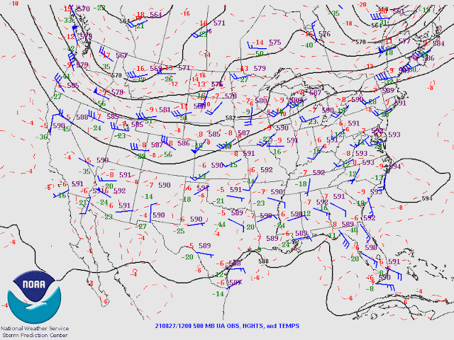
I was uncertain if a discussion was warranted, but it appears just enough moisture/CAPE is present for a chance of storms later today/tonight around Tucson. The 500mb pattern certainly doesn't look very good with a broad trough over the NW CONUS. The ridge is suppressed and is located over southern Arizona, resulting in light and variable steering flow.
The 12Z sounding data is a mixed bag with light winds through most of the profile. Low-level easterly flow is present at Tucson (and east of there), which is typically unfavorable. However, some CAPE is present, with MU CAPE of 800 J/kg at 700mb. MLCAPE is marginal at 360 J/kg.
The above didn't support a discussion today, but the GOES-derived CAPE has increased during the morning hours over parts of the state, including Tucson and east of Phoenix, which is likely to support quite a bit of activity.
Initializations
I am focusing on the CAPE initialization/forecast as there is quite a difference between initializations. The 6Z/9Z/15Z runs have quite a bit of CAPE by early afternoon and a similar distribution as the GOES CAPE. The 12Z RR seems to be the odd man out as it has quite a bit less, around 500-800 J/kg, similar to the 12Z Tucson sounding. As it's 4 against 1, probably the 12Z WRFRR will not have enough activity.
Day 1
A weak surge gets underway today, increasing moisture mainly over far southern Arizona. Somewhat drier and unfavorable downslope easterly flow is present over southeastern Arizona. A weak area of low-level convergence is in place over eastern Pima County, enhancing storm activity.
850mb dew-points are marginal, at best, for lower elevation storms. However, the surge is advecting moist air into far southern Arizona.
CAPE is also marginal for much of the state, but it's quite high over the higher elevations of eastern Arizona.
Storms take a while to get going, and by late afternoon, scattered activity is only in far eastern Arizona/western NM, and some strong storms in the higher CAPE along the border. At this point, it doesn't look very good for the lower elevations.
The surge and outflow manage to increase moisture and CAPE over much of Pima County this evening.
As seen above, the PBL is quite dry but has a deep mixed layer, resulting in favorable conditions for strong winds. The activity in eastern Arizona manages to create strong outflow boundaries, which move towards the Tucson area this evening.
Wow, the PBL is very deep, with a significant inverted-V profile. CAPE is around 6-700 J/kg, which may be sufficient to support deep convection when the outflow boundaries arrive. The wind profile is marginally better, with a little easterly steering flow and a little low-level shear.
This evening, storms form in SE Arizona on the leading edge of the outflow boundaries.
Storms continue into the late evening for southeastern Arizona.
The risk for severe winds is present due to the inverted-V profile. The 15Z WRFRR has a 50-knot wind in the Tucson valley this evening!
Day 2
PW generally increases over southern Arizona, mainly due to a strong outflow-driven surge from an early morning MCS in northern Sonora. Low-level easterlies from NM are no longer present.
Enormous CAPE is present over western Arizona, but it's probably strongly capped. CAPE is low to moderate over the rest of southern Arizona.
The vertical wind profile looks much better at Tucson, with a strong surge providing low-level shear, mid-level easterly steering at 10-15 knots, and upper winds that will blow anvils away from the storm motion. CAPE moderate at 800 to 1100 J/kg. Thus it looks favorable for more storms tomorrow.
Storms again are scattered over southeastern Arizona by late afternoon. Tucson may again see storms.
Storms try to move into Phoenix from the north but die out as they move into the lower elevations as there isn't any CAPE.
Nora is on the horizon for next week.


No comments:
Post a Comment
Note: Only a member of this blog may post a comment.