Previous Forecast
Activity increase over eastern and southeastern Arizona, but only a weak storm or two was all the Tucson area saw. The model runs struggled in SE Arizona as many didn't have enough activity. The 15Z WRFRR was the best except for one major miss: it developed strong/severe storms in Tucson. The 15Z WRFRR also predicted the large MCS that rampaged through the coastal plain of Sonora.
The HAS cloud camera has certainly had some pretty movies recently. I grabbed a few frames from last night's activity.
Discussion
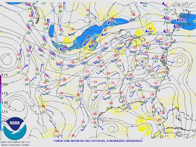
A broad trough continues over the western CONUS, resulting in the ridge axis from souther California off to the east. Flow is mainly light and variable over Arizona. There is a weak trough over New Mexico.
There is an upper trough moving across Arizona, which may help storm formation and organization. Certainly, it will help steer anvils away from storm motion, at least in southern Arizona.This is one of the more impressive MCVs that I've seen. The cloud shield covers almost all of Sonora and looks very similar to a decaying tropical system. A strong outflow surge is underway over SW Arizona with wind gusts above 30mph and dewpoints in the mid-'70s. The 6Z GFS is missing both the MCV and the associated clouds. The 12Z NAM has a weak IT in Sonora but not nearly enough clouds. The obvious choice is the RR series, and it should perform fairly well.
Day 1
The outflow-induced surge weakens by this afternoon, but it did manage to increase PW over most of the southern 1/2 of the state.
850mb dew points are looking much better over central and western Arizona, but dry air is still present over far SE Arizona due to low-level downsloping easterly flow.
CAPE is high over much of southwestern Arizona and even quite high in the Tucson area. CAPE is also sufficient to get storms going over the higher terrain of the Rim and White Mountains.
Storms really get going over western Pima County. Storms also manage to form over eastern Pima County as well.
While Phoenix has quite a bit of CAPE and good steering flow, the mixed layer is shallow, so it will be difficult to get deep convection going.
During the evening, storms move into Pinal County and slowly dissipate. At least in this run, no activity is expected for Phoenix.
The 15Z WRFRR manages to develop a few storms north of the Phoenix area. This results in multiple outflow boundaries into the Phoenix area.
Strong to severe storms develop as outflow boundaries interact, just west of Phoenix. Both the 9 and 15Z WRFRR do this, so maybe it will occur. A lot of things have to come together to make it happen, though.
Day 2
Nora comes into play tomorrow, as, by early afternoon, it is entering the mouth of the Gulf of California. The official track is still right up the gulf, which, if true, the hurricane will be able to keep some organization, probably as a tropical storm. Note the deep easterlies over west Texas and NM, probably in response to the tropical system.
This easterly flow makes it into Arizona and results in mainly dry conditions for much of the state.
CAPE is low over most of the state but probably sufficient to support a few storms.
Moisture finally increases during the early morning hours.
Weak activity develops as the moisture moves into the state.


No comments:
Post a Comment
Note: Only a member of this blog may post a comment.