Previous Forecast
It was a down day for much of the state. The model runs were all quite accurate, except for the WRFRR, as it had activity a bit too far north. The WRFRR has been struggling lately for some unknown reason.
Discussion
The 500mb anticyclone center has moved to around Vegas, resulting in a more favorable southeasterly steering flow over southern Arizona. Temperatures are still fairly warm at -4 to -6C, but better than the past few days. A broad IT appears is located over NW Mexico. Satellite imagery shows multiple MCVs in over Sonora after the big thunderstorms that occurred there last night.
Another trough is over the NW CONUS and may eventually suppress the high center back to the south. 300mb winds are westerly, with neutral or weak confluence over the state.
Phoenix still has issues with the inversion at 500mb and mainly westerly winds. Some southeasterly winds are trying to reestablish around 500mb, though. MLCAPE is only around 500 J/kg. Overall, a little better at Phoenix, but probably not good enough.
Initializations
It is clear over most of the state except for the SE corner. Most of northern and central Arizona is still dry, with PWs as low as 10 to 15mm. 6Z cloud initializations were accurate, while 9-12Z RR initializations have somewhat too thick clouds over SE Arizona, along with some showers. PW was initialized well, except for the 6Z NAM. The 12Z NAM was better but a bit too wet in eastern Arizona. None of the initializations picked up the MCVs, but most had a weak to moderate IT over NW Mexico. The 12Z WRFRR will have issues in SE Arizona as continued the clouds and showers there until late morning. Most other runs should be better.
Day 1
The MCS in Mexico has reinforced the ongoing surge and moisture increases for southcentral and southeastern Arizona.
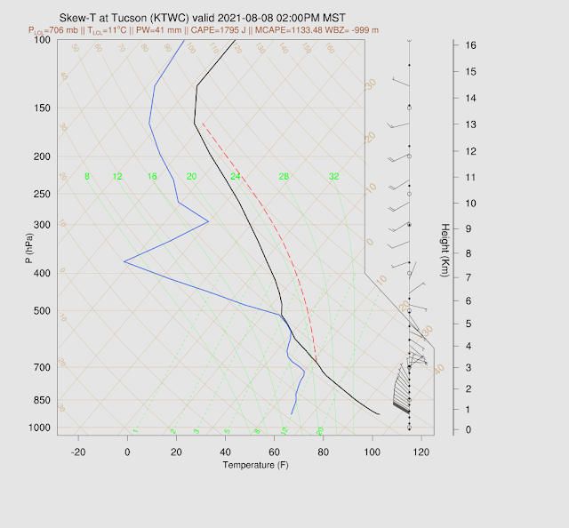
CAPE is very high by early afternoon for much of southern Arizona. The below forecast looks quite similar to the 17Z GOES derived CAPE.
There isn't much agreement about when or where storms form over southern Arizona this afternoon. The WRFGFS is the most active and has strong/severe storms over Santa Cruz and Cochise Counties by late afternoon.
The atmosphere looks to be quite worked over for southeastern Arizona, but CAPE is high in the Phoenix vicinity, even with the thick cloud cover.
The 12Z WRFRR and NAM generally have less coverage but more storms over central/western Pima County.
By later afternoon/early evening, many runs develop an organized line of storms that moves in or close to the Tucson area. If Tucson doesn't get anviled, this could happen. I'm leaning towards the more active runs as the cloud camera time-lapse from this morning shows strong low-level westerlies are now in place, and with the approach of the IT, low-level shear should improve. Another reason that I think the more active runs will verify is that PW has been increasing all morning at Tucson, and at 16Z, it is now 41mm.
The 12Z WRFRR and NAM have very little activity, so uncertainty for Tucson is high. The 9Z WRFRR is in the middle, with more activity around Tucson but not much in the city.
The more active runs move storms towards the Phoenix area during the evening hours.
No runs develop storms in the Phoenix valley, but they aren't out of the question. CAPE is sufficient, and the PBL is mixed deeply. The wind profile isn't too bad either.
Day 2
An inverted trough moves into the state during the early morning hours, resulting in widespread morning clouds and showers. This will seriously impact heating and likely result in minimal afternoon and evening activity.
PW continues to increase and, by early afternoon, is very high over central and western Arizona. The surge has weakened by this time. Thus low-level shear will probably be weak by later in the afternoon.
The inverted trough continues to move across the state during the afternoon. The high center moves to western NM, and moderate southerly to easterly steering flow is in place over the state.
It will be tough to get any deep convection going due to the capping inversion around 850mb. CAPE and the wind profile are excellent, though.
Most runs have minimal or no thunderstorm activity for the state during the afternoon and into the evening hours.


No comments:
Post a Comment
Note: Only a member of this blog may post a comment.