Previous Forecast
Not much happened during the day, but widespread rain and a few thunderstorms developed over much of central and southcentral Arizona later in the evening.


Discussion
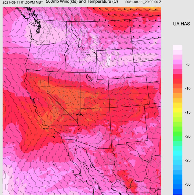
The large inverted trough continues to move slowly through the state and is responsible for the widespread clouds, showers, and thunderstorms continuing over central and southern Arizona. The 500mb ridge is building out west for another intense heatwave. One center is over Nevada, and another is located far to the east over the SE CONUS.

300mb flow is generally southwesterly over much of the SW CONUS, and a trough is located over Northern California. 300mb flow looks neutral over the SW with no convergence/divergence except near the IT over Arizona.


Initializations
It is another challenging initialization situation. The 6Z WRFGFS initialized pretty well, considering, but is missing the deep convection over SE Arizona. The satellite imagery shows that the trough is located near Gila County and the 6Z WRFGFS was close. The 9Z RR did an excellent job with cloud and shower/storm locations and has the IT located in Gila County. I'm impressed! The 12Z RR missed the SE Arizona storms but otherwise was pretty good. The 12Z NAM didn't have any of the southeastern Arizona activity. PW was also initialized well by the GFS and RR, which is especially surprising to see in the areas of ongoing activity. A complex day like this wouldn't have had a prayer of getting initialized correctly back in the old days. It's the WRFGFS or WRFRR today. As a side note, the various WRFRR runs alternated PBL schemes, but in this moist air mass, the BouLac scheme has been much too active, and all WRFRR runs are back to the MYNN scheme.

Day 1


 It's certainly possible with the elevated CAPE of around 1000 J/kg.


By early afternoon, the IT has only moved a little and is over Coconino County. Most of southern and central Arizona is on the backside of the trough, resulting in somewhat warmer mid-level temperatures. Generally, the backside is more stable due to NVA/descending motion.

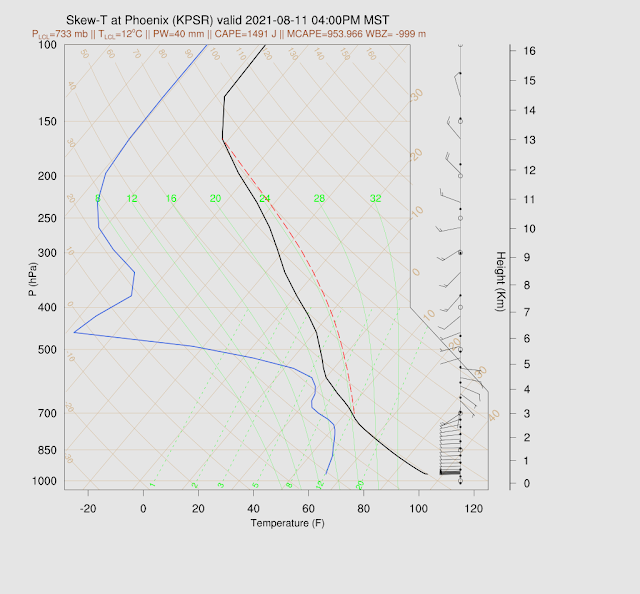
The afternoon Phoenix Skew-T indicates a very moist but shallow mixed layer. Above the PBL, it's not as dry as yesterday's forecast. There is a cap on top of the mixed-layer, so deep convection may be tough to trigger, but with ~1200 J/kg CAPE, not impossible.

Tucson is in a similar situation, with a shallow moist mixed layer with a lot of CAPE but a weak inversion at the top of the mixed layer, plus a subsidence inversion around 500mb. It is going to be difficult to get through this inversion. In addition, there is quite a bit of activity as of 16Z in Tucson, so the actual afternoon vertical profile may look quite modified, with little CAPE available.

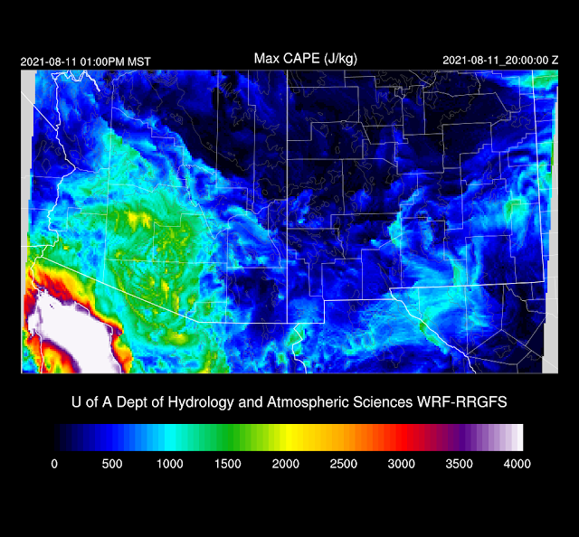
The afternoon forecast has minimal CAPE over central and northern Arizona, which looks right due to the widespread clouds and showers. South-central and southeastern Arizona manage moderate to high CAPE, as that area is receiving some heating.

Far SE Arizona becomes quite active by mid-afternoon as that area was not worked over by earlier activity, and it's partly cloudy there now.

Storms expand/move to the NW into the early evening. Both the 9 and 12Z WRFRR are similar. I'm not sure they will make it this far west as there is morning activity in this area, possibly keeping it cloudy and cooler. The other area of interest is NW Arizona, where an organized line of storms moves towards the Colorado River. CAPE is high, mostly clear, and has a favorable steering flow, so this looks accurate.

Storms continue west of Tucson and in western Arizona into the evening.

The storms in western Arizona could produce severe winds.

Some runs do forecast early morning activity in the Phoenix area, again.


Day 2
I have little confidence in the forecast due to the complexity and uncertainty leading up to Day 2. The large scale pattern has a building west coast ridge with one center off the Washington coast and temperatures warmer than -5C. I didn't think we'd see another one of these heat waves of this magnitude. The rest of the southwestern CONUS has mainly light and variable winds, except near the inverted trough, still hanging around western Arizona. Temperatures are quite warm over southern Arizona.

TS Kevin has quite a large circulation but looks too far away to help initiate a surge. In any case, the air mass over Arizona remains very moist, with PW in the 37 to 47mm range for southern Arizona.

CAPE is high over much of central, southwest, and south-central Arizona by afternoon.

Tucson has a decent amount of CAPE, but the wind profile is poor, as there is little or no mid-level steering flow. Other issues are a fairly shallow mixed layer and multiple inversions. Phoenix looks much the same.


The WRF runs keep deep convection restricted to the higher elevations.

No comments:
Post a Comment
Note: Only a member of this blog may post a comment.