Previous Forecast
SE Arizona was the active spot yesterday. A few storms also moved off the high terrain into Phoenix and eventually made their way to southwestern Arizona.

The gold medal goes to....wait for it....the WRFNAM.

Discussion
The 500mb western CONUS continues to build, and heights are again almost 6000m. At 0Z, two stations reported 5990m. Incredible. Fortunately for Arizona, the center is located far to the NW, over northern NV. Arizona is under deep easterly flow, with mid-level winds from 15 to 25 knots. A broad IT is located from around northern Baja all the way back to west Texas. Note the trough and -11C air over Kansas/Nebraska. I'll talk about it later.


I about jumped out of my chair when I saw the 12Z Phoenix sounding! 2000 J/kg of MLCAPE and a PW of 56mm. Since the sounding was taken, Suominet PW at San Tan has dropped to 41mm, so CAPE isn't that high now. As mentioned yesterday, the low-level easterly flow appears to dominate at least the eastern 1/2 of the state, which is likely the reason for the drying trend.


Thick clouds and some showers and storms covered all of the southern parts of Arizona into far southern NM around 12Z. Clouds have begun to dissipate since then but are still quite thick over southern NM. The morning initializations are all quite good with locations and amounts, except the 12Z NAM, too thick over southeastern Arizona. The 6Z GFS initialized a strong closed circulation just south of Nogales, which doesn't seem to exist from satellite imagery. The only obvious closed circulation is near El Paso. The rest of the initializations have initialized the upper-air features more accurately. PW was initialized well, except for the NAM. Again, it looks like the RR has the best initializations today.

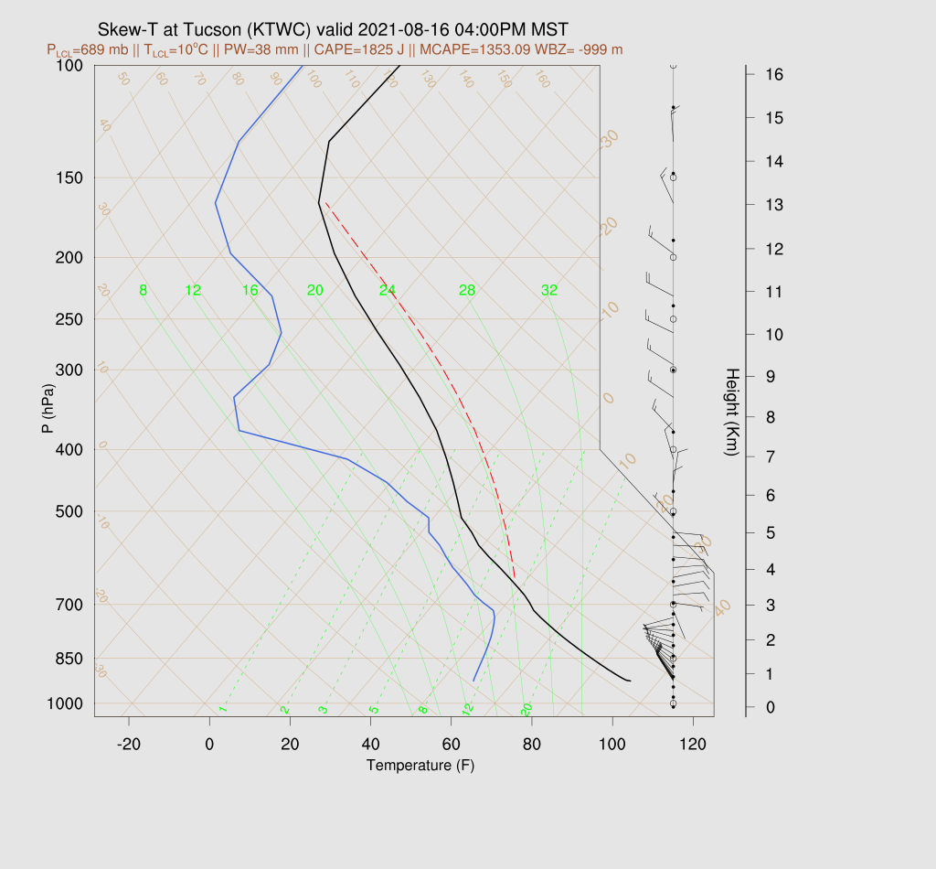
Day 1
As mentioned earlier, easterlies dominate the lower troposphere all the way to the surface. Despite very moist air over most of southern Arizona and upstream in SW NM, this is a negative for storms today and tonight due to downslope winds and the absence of low-level shear. As mentioned above, PW has already decreased around the Phoenix area, and that trend continues into the early afternoon.


There is an amazing consistency as all runs are about identical by late afternoon. They develop strong/severe storms west of Flagstaff and move them toward west-central Arizona. Another area of storms develops over the Chuska Mountains of NE Arizona. These bear watching because, as we've seen on multiple occasions, they can stay organized and move into central Arizona later in the evening.

Model consistency goes away by later in the evening, as only a few runs manage to keep the Chuska storms going into central Arizona. The storms in NW Arizona dissipate as they move into the lower elevations, so the atmosphere must be strongly capped.

The runs disagree about the amount of evening CAPE around Phoenix. Some runs have quite a bit, as low-level winds shift around to the west and bring in more moist and unstable air. Steering flow continues to be excellent with 15 to 25-knot northeasterly flow. Still, only one run manages to move storms into central Arizona.

The Tucson forecast Skew-T also indicates a potential for activity as winds are excellent, CAPE is high, and the PBL is deeply mixed. Models disagree on the amount of CAPE available as some runs have much less as the low-level easterly flow continues.

While many runs have favorable vertical profiles this evening, only one manages to move storms into the lower elevations, so don't bet the farm on the below forecast.

Many factors are coming together for a huge day tomorrow. An upper trough drops down into eastern Arizona, with a weak jet streak entering northern Arizona.

This trough also extends to 500mb and is located about over the Four Corners by early afternoon. Temperatures are a cool -7 to -10, which is the coolest air of the season so far. The steering flow continues to be excellent.

The surge restarts overnight and is quite deep, as it's seen at 850mb. Dew points are quite high, 13-15C for the lower elevations.

And now for the most exciting part....CAPE is high to extremely high over much of the state due to the high moisture and cooler temperatures aloft.

Some runs are just bonkers, like the 12Z WRFGFS.

I'm trying to not get too excited, but these Skew-Ts are insane, and these are from the more moderate 12Z WRFRR.


The 9 and 15Z WRFRR are extremely active, with multiple areas of severe storms and some Bow Echo-looking structures.

No comments:
Post a Comment
Note: Only a member of this blog may post a comment.