Previous Forecast
There was little or no activity for Tucson or Phoenix for once due to all the previous activity and morning cloud reducing heating. Big storms roamed over much of western Arizona yesterday afternoon and into the night. New Mexico was very active as they are under the influence of their very own IT.
Model forecasts turned out to be pretty good, except the NAM, for once.
Discussion
The Arizona IT has finally moved some and is located somewhere around Yuma. The New Mexico IT is quite strong with 20-knot winds and is roughly located over NW NM. The anticyclone center stretches from western CO to WA, resulting in a brisk flow of 20 to 25 knots over northern Arizona. Temperatures are quite cooler over northern Arizona at -8C but still warm over southern Arizona and New Mexico at -5C. It's been many years since we've had so many inverted troughs.
The 300mb anticyclone has moved north over NM, with a weak trough over Vegas and a large upper IT over NE Mexico. Flow over areas is now generally light from the south or southwest, which is great for blowing anvil tops in the opposite direction of the storm motion.
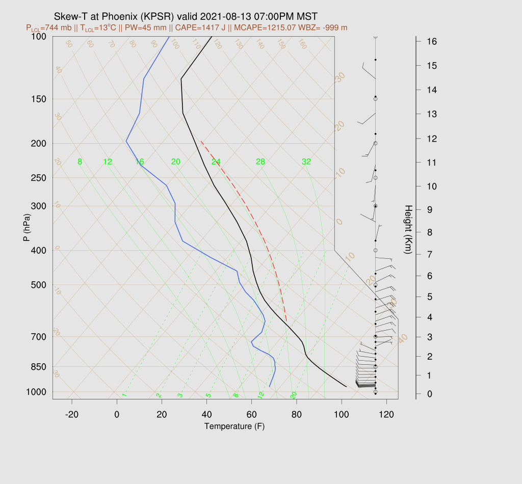
It looks like all the ingredients are coming together for a very big evening. The Phoenix 12Z sounding has all the good stuff: 1300 MLCAPE, low-level shear, mid-level easterly steering flow, and southwest winds aloft. The temperature profile has only weak inversions at 700mb and 400mb.
Tucson, not quite as good-looking, but still around 700mb MLCAPE, and no significant inversions. The wind profile is light and variable in the mid-levels, but that should improve as the day goes on.
Initializations
Widespread clouds are over much of NW Arizona and scattered about the rest of the state. Fortunately, there are no significant areas of precipitation. It's also very cloudy in the vicinity of the NM IT. PW is quite high for most areas of the state. 40-50mm for the lower elevations, and 25 to 50mm for the higher elevations. Puerto Penasco reports 56mm!
The 6Z GFS was generally accurate, but it was too cloudy over southeastern Arizona. The 12Z RR generally had clouds in the right locations but might be too thin in Arizona. The 12Z cloud initialization was OK too.
Day 1
The very moist air over the state continues today. 850mb dew points are very high at around 15C. The surge is not as strong/deep as it has been, but there is still a signal at 850.
Moderate to high CAPE is present over nearly all of the lower elevations of the state. Impressive!
The NM IT drifts westward and is over southwestern NM by early this afternoon. This results in a strengthening of the NE to E flow over much of northern and central Arizona. This flow is optimal for steering higher elevation storms, in an organized fashion, to the southwest and into the lower elevations. 500mb temperatures remain quite cool, with most of the state at -7C or less. Everything is in place for a widespread thunderstorm outbreak for much of southern and central Arizona.
Thunderstorm development is slow to occur, but strong storms are underway over much of the eastern 1/3 of the state by late afternoon.
The mid-level steering flow improves at Tucson with 10-15 knots of easterly flow by later afternoon. Everything else with the wind profile is favorable for thunderstorms. CAPE is a decent 800-1300 J/kg, and inversions are minimal. All systems are go for liftoff.
Areas of organized strong to isolated severe storms continue to expand in coverage towards the Tucson and Phoenix area. All morning runs are quite similar regarding southern Arizona but differ a little around Phoenix. The 12Z WRFRR has a bit less activity, at least at first, upstream of Phoenix.
Most runs develop strong/severe storms over the higher terrain to the north and northeast of Phoenix. (9Z WRFRR)
Everything is in place for a major storm event in Phoenix, as well. The only difference is that a cap is present on top of the mixed layer, which will take strong OFB or OFB interactions to break. The surface-based CAPE calculation looks too low and looks more like 1500-2k J/kg. With CAPE, this high, severe weather is likely.
Strong to maybe severe storms move through Tucson around 8pm to 9pm and then into the Phoenix area around 9-11pm. By this time, the 12Z WRFRR catches up to the other runs and has widespread storms for much of south-central Arizona.
Phoenix seems to have a higher risk for damaging winds. DCAPE is only 770 J/kg from the morning sounding, but some isolated severe winds will likely occur due to wet microbursts.
Strong to isolated severe storms continue through western Arizona into the early morning hours.
The 15Z WRFRR has storms, some severe, a bit later for Phoenix, after midnight.
Day 2
I don't have any time to look at Day 2, except to say that it's likely to be much less active due to all the activity from the previous day. Some runs do develop storms north of Phoenix tomorrow night.


No comments:
Post a Comment
Note: Only a member of this blog may post a comment.