Previous Forecast
The thick morning clouds eventually burned off, which resulted in scattered, very heavy thunderstorms. Parts of Tucson got hit with some reports of over 1.5" in the central Foothills. Typically, the WRF has struggled with not enough clouds. Yesterday, it was the opposite as it kept mostly cloudy skies throughout much of the day. This resulted in WRF being way off with the timing of the storms.

No model performed well. The 12ZRR was way off on timings but did eventually form storms over southeastern Arizona. The runs really went off the rails in NM as they all missed the heavy precipitation, as well as just south of the NM bootheel.

The 12Z WRFNAM was about the same.

It's now all tied up at 1-1 as the HRRR won the battle of the models yesterday. It developed storms around the Tucson area during the afternoon and generally had the right idea about amounts and locations.

22Z

Discussion
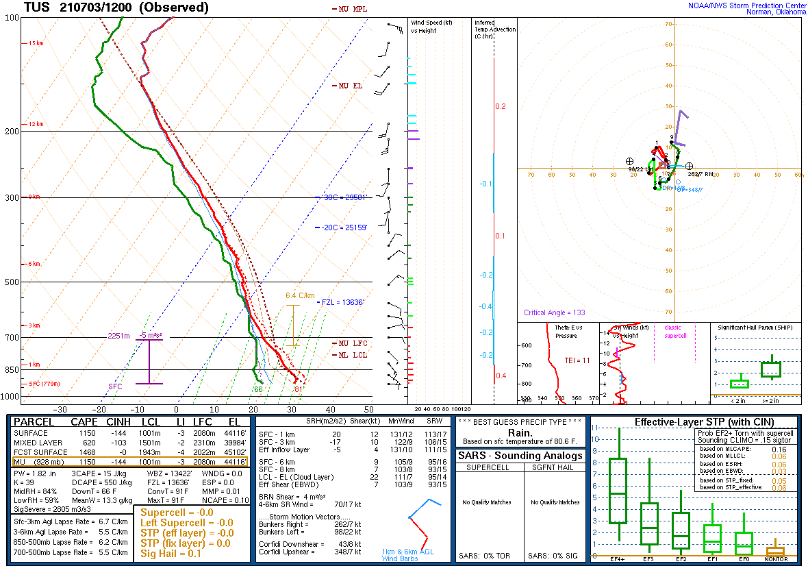
The story continues to be the extremely moist air that is present over the state. PW is in the mid 40mm range over the southern 1/2 of the state and 50mm at Puerto Penasco! Tucson's upper-air data indicates a moderate amount of CAPE, little or no inversions, and decent mid-level steering. It won't take much heating to trigger deep convection and heavy rain.

The 500mb pattern indicates the center of the anticyclone is in a pretty good spot, somewhere over northern Arizona. A broad cyclonic circulation is over NW Mexico. Satellite imagery does show a weak MCV moving into Cochise County. Both these features should help organize/enhance storms today and tonight.

Initializations
Scattered to broken clouds are present over much of southern Arizona. They aren't as thick as yesterday, so heating will be better. No initialization did well with clouds. Either too much or not enough. The 12Z RR was the best, followed by the 6Z NAM. The 6Z NAM also initialized the MCV, somehow! I don't have confidence in any of the runs today, but the 6Z NAM and the 12Z RR appear to have the better initializations.

Day 1
Moisture continues into the afternoon. Central and eastern Arizona has 850mb dewpoints in the favorable range of 10 to 14C.

CAPE is moderate over SE Arizona so, it's likely that area will be the most active today and tonight.

I'm not sure about the timing due to the clouds, but at some point this afternoon, storms develop over the higher terrain of SE Arizona and along the Mogollon Rim.

It sure looks good for the Tucson area later today. The wind profile is good with a little low-level shear, good mid-level ESE steering at 10 to 15 knots, and upper winds blowing anvils away from the storm motion. There is more good stuff with a well-mixed PBL and 800-1200 J/kg of CAPE.

Some strong to severe storms in eastern Pima County by later today.

Phoenix has many of the pluses that Tucson has: good vertical wind profile, well mixed, and a lot of moisture. However, CAPE is a bit marginal at 200 to maybe 1000 J/kg. In any case, the steering flow should bring storms into the area this evening.


The 6Z WRFNAM is interesting as it moves stronger storms into central Arizona because they are better organized due to the influence of the old MCV. These things are always difficult as sometimes they do nothing and other times help enhance storms.

The 15Z WRFRR is similar to the 6Z NAM as organized storms move into Phoenix this evening.

Day 2
Hard to believe, but the moisture increases over the state. PW is above 50 mm for parts of the lower elevations!

CAPE is moderate over eastern Arizona but quite low in central and western Arizona despite all the moisture.

This lack of storms was certainly a surprise to me when I first looked at Day 2. Only a few scattered storms over the eastern 1/3 part of the state.

It turns out that the additional moisture plus the warming of the mid-levels results in multiple inversions, keeping storms limited.

Tucson is better mixed, so perhaps some storms are possible.

No comments:
Post a Comment
Note: Only a member of this blog may post a comment.