Discussion
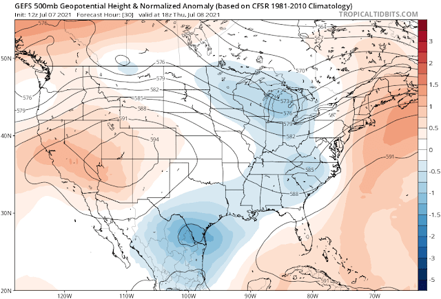
Moisture has increased somewhat since yesterday over southeastern Arizona and is enough to support scattered storms. The 500mb map shows a strong anticyclone centered over northwestern Arizona, resulting in favorable northeasterly steering flow over the eastern 1/2 of the state. Temperatures are all over the place, with Yuma and vegas at -8C while Tucson and El Paso are less favorable -5C. -1C at San Diego, which is quite incredible.
This warm layer is visible on the 12Z Skew-T for Phoenix, just above 500mb, where there is a strong inversion.
Initializations
An area of deep convection moved south across western NM last night, resulting in some debris clouds over far southwestern NM and southeastern AZ. Elsewhere, only think broken to scattered clouds are present. PW is very high just south of the border, 1.5 (purple) to over 2" (yellow). Cloud initializations were pretty good by the GFS and RR. The 12Z NAM had too many clouds in eastern NM but shouldn't be a factor in Arizona. PW initializations were all accurate except for the 12Z NAM, which was way too wet in NM. The NAM has become the worst initialization over the past few years as it's been "frozen" with no recent improvements and limited or no GPSIPW assimilation. I'm slowly increasing the number of Rapid Refresh WRF runs as the native RR now goes out to 51 hours, and for longer runs, I use the GFS lateral boundary conditions. Note that there is a 9Z WRFRR as of today. In any case, the favored initializations are the GFS and RR, and they should perform well.
Day 1
Moisture stays the same or increases slightly as a weak Gulf Surge continues today. Low-level easterly winds increase over southern NM, and fortunately, they haven't made it into Arizona yet. This does set up a low-level convergence zone over southeastern Arizona.
CAPE is restricted to far eastern and southeastern Arizona and is sufficient to support storms.
Storms develop over the high terrain of far eastern Arizona this afternoon and move/develop, as anticipated, towards the SW.
Well, this isn't looking very good for Tucson. PW decreases somewhat later in the afternoon, and the 400mb inversion strengthens, resulting in only minimal CAPE. The steering flow is certainly optimal, though.
It's a different story just to the south and east of Tucson. Nogales is wetter and has a moderate amount of CAPE.
Scattered storms move/develop over far southeastern Arizona by late afternoon. At this point, it looks like only a strong outflow boundary moves through Tucson, but storms are going to be close.
The 9Z WRFRR is a bit more active, with some strong storms over Cochise County.
Day 2
The 500mb anticyclone center shifts to the Four Corners and strengthens. In the "old days," a Four Corner High would be a favorable monsoon pattern.
The subsistence from the building high results in drying of the air mass in NM and easterly low-level winds advect this dry air into eastern Arizona, just like so many days last year. I fear this is going to be the case again for much of the summer. I hope I'm wrong.
It does look favorable for storms in a narrow area from central/western Pima County up into Gila County.


No comments:
Post a Comment
Note: Only a member of this blog may post a comment.