Previous Day
Wow, it was quite an evening. Practically all of Pima County received significant precipitation. There were many reports of high winds and hail.
The model runs significantly underpredicted precipitation but generally did well regarding the severe weather locations and timing. The WRFNAM, despite all my bitching about it, and GFS generally had the best depiction of precipitation.
Discussion
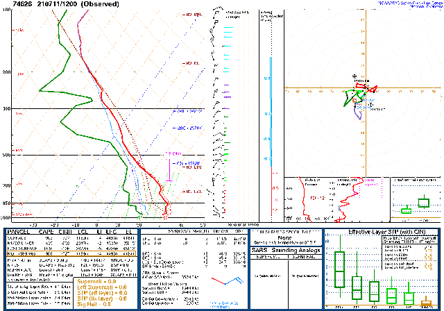
As is typically the case after a major event, the next day is relatively quiet. The lower layers of the atmosphere are cooled, the ground has been cooled and wetted, and drier air is present just above the surface, brought down from higher levels during deep convection, reducing MLCAPE. Both Tucson and Phoenix exhibit this worked over air mass at 12Z.
The 500mb anticyclone center has moved slightly to the northwest resulting in somewhat lower heights and slightly lower temperatures, so generally more favorable for Arizona. Mid-level steering flow is still optimal for moving storms into the lower elevations.
On a side note, this discussion is late as I'm installing my new Davis VP2 asperated weather station. This station can mount the anemometer separately, so I mounted it above my shed at about 7m agl. Bring on the storms!
Initializations
Clear skies are present over all of the state. No obvious cyclonic circulations except for maybe a weak inverted trough over SE Arizona. The 6Z initializations had some large PW initialization errors, which isn't surprising due to widespread/ongoing deep convection. 9Z and 12Z initializations had only minimal errors, so I'll use those.
Day 1
Moisture continues to be imported into the state from an ongoing Gulf Surge. The moist air has made it to far eastern Arizona, pushing the dryline back into NM.
CAPE is moderate to high over much of the southern two-thirds of the state. As mentioned above, widespread storms don't usually form/move over areas that have had previous activity. Using the lightning data, this would include much of central and south-central Arizona. For far southeastern Arizona, CAPE is high, and there was no previous activity, so perhaps that will be the active area today, especially considering the local convergence from the dryline.Storms take their sweet time initiating today. By late afternoon, there are quite a few over far eastern Arizona into SW NM. Steering is optimal for moving them toward Cochise and maybe far eastern Pima Counties.
Storms move into far SE Arizona during the evening hours.
As was the case yesterday, very strong/isolated severe winds are possible. Could there be another round of late-night storms for the Tucson area? Strong convergence occurs on the edge of the OFB and the quite strong low-level westerly flow.
The potential is there as CAPE is somewhere around 1000-1700 J/kg. However, upper winds may blow anvils out ahead of the storms unless they can propagate faster than the flow.
There is a lot of uncertainty as the model runs are quite different. The GFS is much more active (and moister) for SE Arizona and develops severe storms near Tucson.
The WRFNAM and RR have most storms farther east.
There is an impressive amount of CAPE forecast for Phoenix this evening. However, there are some reasons that storms are unlikely. The main reason is there is a substantial inversion on top of the mixed layer. Multiple intersecting OFBs would be needed for storm formation. Also, upper winds will move upstream storm's anvils out ahead, shading and providing weak downward motion.
Day 2
The long-lasting Gulf Surge continues tomorrow, resulting in a very moist air mass over the state. It's quite strong as there is a significant signature even at 850mb. The low-level easterlies are back again for SE Arizona but will result in some favorable low-level convergence and storm enhancement/initiation west of there.
CAPE is very high to the west of the dryline, and that area is likely to be very active.
Here we go again! Storms form late in the day and move towards the lower elevations of Maricopa, Pinal, and Pima Counties. These discussions are way more fun to write compared to last year!
The WRFGFS is the most active and has storms moving into both Tucson and Phoenix during the evening hours.
The WRFNAM and RR don't have much activity around Phoenix, but Tucson certainly does. A few storms will likely be severe. Also, with a moister air mass, the flash flood risk increases.


No comments:
Post a Comment
Note: Only a member of this blog may post a comment.