Previous Forecast
Scattered storms formed in east-central Arizona during the afternoon hours and moved to the southwest and eventually into eastern Pima County. Most rainfall was light. A huge complex of storms moved across Sonora, which has resulted in a surge of moisture into central and western Arizona this morning.
WRF performance was variable. The 6Z runs didn't have enough activity, and the 12Z WRFNAM and GFS had too much. The 12 and 15Z WRFRR were just right. However, no runs (outer domain) predicted the extent of the Sonoran MCS. So far this season, the MYNN PBL scheme has sometimes struggled with not enough activity. I am now making a few runs (6Z and 9Z) using the previous monsoon season PBL scheme, the BouLac.
The HRRR had too much activity in far southeastern Arizona. However, it did do well in Sonora.
Discussion
PW has decreased over eastern Arizona but has increased over central and western Arizona in response to the outflow surge from the overnight Sonoran MCS. GOES-derived CAPE of 500-1000 J/kg is present in this area.
The 12Z Phoenix sounding indicates about 500 J/kg of MLCAPE as well as a weaker mid-level inversion. Deep ENE flow is also present, optimal for steering Rim/White Mountain storms into the lower elevations. As a side note, my unofficial monsoon indicator has been met as there has been an easterly component to the 300mb winds since the 5th. Another positive for today is the lack of a low-level capping inversion. There is probably one to the southwest, but there was no sounding from Yuma to verify.
Tucson has a similar amount of CAPE, but there is a shallow inversion near the surface and a strong mid-level inversion, so it might be tough to get much activity in the area.
The 500mb anticyclone center hasn't moved much since yesterday and remains over northern Arizona. It has not moved to the Four Corners and strengthened. (yet?)
Initializations
It looks like a straightforward initialization this morning as skies are mostly clear, with no identifiable inverted troughs or MCVs. PW initializations are good, except for the usual wet bias of the NAM. There is no clear favorite, except not the NAM, and model confidence is high.
Day 1
The 850mb plot clearly shows the line between the very moist air in central and western Arizona and the drying/downsloping air over eastern Arizona. I expect some activity along and west of this line later today.
This boundary is even more clear on the CAPE plot! No CAPE in southeastern Arizona at all. It looks like the area outlined will have some activity later today and tonight as storms form at higher elevations and move to the southwest.
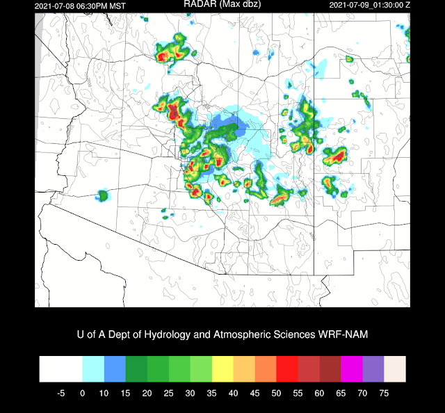
Most runs do develop scattered storms along the Mogollon Rim by late afternoon. The 12Z WRFRR is the exception, which is concerning as it has been one of the more accurate initializations.
There is a big discrepancy between the amount of moisture and instability around Phoenix later this afternoon. The 6Z WRFGFS has a good amount of CAPE and a fairly well mixed PBL. However, a weak inversion on top of the mixed layer will require a good outflow boundary to provide the lift to break through the weak inversion.
The 12Z WRFRR has less moisture and CAPE, resulting in little or no activity.
It's not looking good for Phoenix except for the (too moist?) 12Z WRFNAM as storms dissipate as they move into the valley. The best case seems to be that a few storms make it into the lower elevations by early evening, but this seems unlikely.
The 12Z HRRR has a bit of evening activity between Tucson and Phoenix and looks similar to the WRFNAM above.
All is not lost as an interesting development occurs during the evening hours. A big surge of moist and very unstable air moves to the northeast. If a few storms manage to hang in there and make it to the unstable air, they could really blow up.
This is what happens in the WRFNAM, as it was the only run that was able to keep storms going as they moved into the lower elevations. Strong to severe storms form during the evening. Again, the WRFNAM is most likely the outlier, but we can hope!
More likely, is that there will be little or no activity. The 12Z WRFRR has a strong cap just above the shallow moist layer. CAPE is damn impressive, though!
Wow! That is about as high of CAPE that I've seen.
The WRFRR 9Z and 12Z become quite interesting for the Tucson area later in the evening. They manage to move a few storms in from the northeast. The 9Z run doesn't have as strong of an inversion and develops some intense storms. Again, an outlier.
Day 2
The surge of moisture continues for much of the state and manages to push nearly to the AZ/NM border.
Lots O'CAPE.
This is going to be a MAJOR problem. There continues to be a significant capping inversion at the top of the fairly shallow mixed layer. Will there be enough heating and outflow boundaries to break on through (to the other side)?
It looks the same for Tucson, except the residual mixed layer is fairly deeply mixed. A strong outflow boundary will be needed to provide the lift needed to reach the LFC.
Storms struggle, at least early in the evening, to make it into the lower elevations.
Some runs do manage to develop some storms late in the evening into the morning hours.


No comments:
Post a Comment
Note: Only a member of this blog may post a comment.