Previous Forecast
It was a busy 24 hours over much of the state as some locations received extremely heavy rain. Flash flooding occurred in Flagstaff and probably other locations as well.
The WRF-NAM and GFS appear to of had the best forecast as they did a better job around Yavapai county. No runs were able to forecast that storms and associated heavy precipitation in western Arizona, though.
Discussion
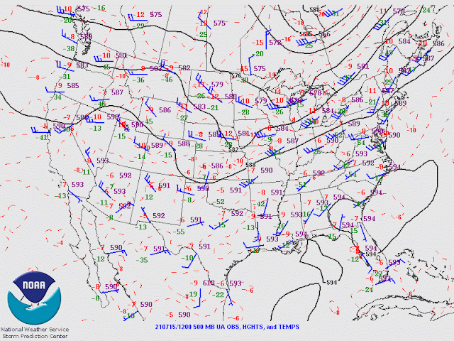
The California anticyclone continues to weaken while a weak trough is over northern Arizona. 500mb temperatures have cooled slightly and have become more favorable. 500-700mb shows a broad cyclonic circulation over NW Mexico. This feature is likely to enhance storms over southern Arizona over the next few days.
PW continues to be very high as it ranges between 44-49mm over the lower elevations of southern Arizona. The 12Z Tucson Skew-T has a lot of CAPE once again, which has resulted in storms forming in the area this morning. Steering flow is still good, as mid-level winds are northeasterly.
Phoenix has only minimal mixed-layer CAPE, and the vertical profile is dominated by the westerly flow from the trough.
Initializations
The situation is moderately complex this morning due to the ongoing convection. A weak MCV seems to be located just north of Flagstaff. The 6Z runs didn't have nearly enough convection or associated clouds, but they did initialize the MCV and its clouds. 9 and 12Z RR did a great job of developing the Pima County storms. 12Z NAM had the right idea, but convection wasn't in the correct locations, and it was generally too cloudy over northern Arizona. The RR has the best initializations. However, the WRFRR, as it did last year, typically has less activity than what was observed or the other runs. PW initializations are mostly accurate.
Day 1
The firehose of moisture continues today as the "longest surge in recent memory" continues. This moist air has made its way into central NM, so perhaps far southeastern might get in on the action. Here in Paradise, the monsoon total precipitation has only been 2.1". Many locations in Tucson have had more!
The two CAPE hotspots are over NW Arizona and in SE Arizona. Those are the areas to watch today.
The morning model runs are widely divergent for activity today. The 9Z WRFRR is somewhere in the middle, so I'm mainly looking at it. By late afternoon, storms are roaming around the Flagstaff area again, so the flash flooding risk is high due to all the precipitation they've had. Other storms are scattered over SE Arizona and SW NM.
The Tucson area will stay quite cool due to the activity from this morning. This results in only limited CAPE later today and probably not enough for evening storms. The wind profile is quite good, though.
Phoenix is looking a bit better as the PBL is mixed nearly to the LFC. The CAPE is sufficient to support some storms but will need some outflow boundaries to break through the inversion at the top of the mixed layer.
CAPE increases around Tucson later in the evening and may support some late evening activity. Some runs develop early morning storms, again, over southern Arizona.
Day 2
The broad mid-level trough that has been wandering around NW Mexico moves to southwestern New Mexico. This feature will enhance storms for much of southeastern Arizona. Favorable northeasterly steering flow is present over much of the state.
Moisture continues to flow into the state, and 850mb dew point temperatures are quite high at 12-14C, so heavy rain is likely to be produced by some storms.
Due to the complex weather situation and the uncertain forecast for even today, the confidence in tomorrow's forecast is low. As long as there are mostly clear skies, storms are likely to develop over southeastern Arizona and move towards Tucson.
Phoenix has enough CAPE to support a few storms. The PBL is mixed deeply. Thus it won't take much of an outflow boundary to trigger deep convection.
Scattered storms continue into the late evening.


No comments:
Post a Comment
Note: Only a member of this blog may post a comment.