Previous Forecast
It was a very active day for areas west and northwest of Phoenix, much more so than what the models had predicted. In addition, storms managed to develop over the eastern part of Phoenix late last night.
Model accuracy was bad, especially the normally well-performing WRFRR. The WRFRR struggled as it kept developing anomalous deep convection shortly after the run started over western Arizona during the morning hours. This stabilized the atmosphere resulting in little or no afternoon storms. In addition, all the morning runs did not develop deep convection in the Phoenix area. The lone exception was the 18Z WRFNAM.
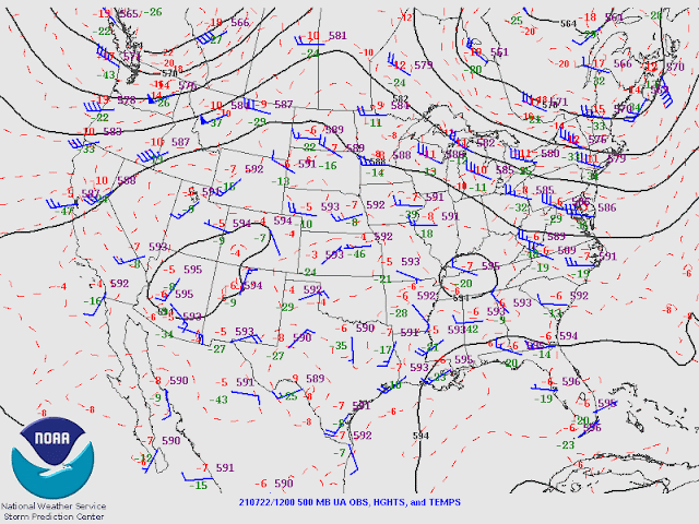
PW has also decreased at Tucson, but MLCAPE is a high 1300 J/kg. Both soundings indicate an inversion continues around 500mb, but as the trough moves closer to Arizona, mid-levels will cool. The IT has already made its appearance; note the 50-knot wind at 200mb.
Very potentially unstable air isn't far away as GOES CAPE values exceed 1000 J/kg just south of Arizona. Rarely do I see GOES CAPE this high.
The really wet air is also not far away, over the central Gulf of California, but it will take a big surge to move it into Arizona.
Initializations
There are a fair amount of high clouds over the state, but no ongoing showers or storms, so the initializations shouldn't have too much trouble. Most initializations were accurate, except the 6Z NAM had too many lower/thicker clouds in some places. The IT is right on the edge of the outer domain and looks to be accurately initialized, except by the NAM, which is too far west. Unfortunately, most Suominet stations in Mexico are now inoperable, and only 3 are available, so it's not possible to easily identify PW initialization errors. At least for the SW US, PW was initialized accurately by both the GFS and RR, but as usual, the 6Z NAM was too moist. To my surprise, the 12Z NAM actually has minimal errors! It's again quite smokey over Arizona, and it does appear that the GEOS5 AOD forecast used by WRF is doing an OK job with solar irradiance.
Overall, the GFS and RR initialized well, so confidence in these WRF runs is high. The 12Z NAM may also be of use today too.
Day 1
Is the surge going to kick in? It may have just started as Yuma area wind speeds, and dew points have started to increase. By early afternoon, the surge is well underway and an increase in PW over central and south-central Arizona.
As was forecast yesterday, the surge is deep and reaches to at least 850mb. 850mb dew points are also high, around 14 to 15C, by early afternoon.
This Gulf Surge is impressive as it stretches all the way down the Gulf of California, even at 850mb.
The various CAPE forecasts for the early afternoon are quite wide-ranging. The middle of the road is the 9Z WRFRR. It has extreme CAPE over far south-central Arizona and moderate to high CAPE over much of the rest of the state.
All runs are nearly identical in developing severe storms along the border of Pima and Santa Cruz Counties by mid-afternoon.
The IT slowly makes its way into the Texas Panhandle this afternoon, resulting in southern Arizona being under difluence aloft. A jet streak associated with the trough is over southern NM and into southern Arizona. These features will help enhance and organize storms this afternoon and into the evening.All runs move the eastern Arizona storms into the Tucson and Phoenix areas during the early morning hours.
The biggest threat is going to be flash flooding. The 4-panel 24 hour QPF has quite a bullseye on Gila County, which couldn't be a worse spot due to the recent big fires there. WRF had large areas of greater than 1 inch, with some isolated areas over 3 inches. WRF usually underestimates QPF, so it could even be more than depicted.
Most runs keep rain and some thunderstorms going until at least sunrise as a large MCV has spun up and is located over southern Arizona.

Day 2
Whew, I'm exhausted from writing about Day 1. Day 2 confidence is low due to the previous widespread activity and the complexity of the overall situation. Clouds and rain continue during the morning hours, forced by the large MCV.
By early afternoon, the MCV becomes an open wave and moves into northern Mexico. The IT has moved little and is located in a favorable position in far southeastern NM. If the atmosphere can recover, expect another round of rain and thunderstorms.
The 250mb forecast has much of Arizona in very favorable upper-level divergence/difluence.
The Gulf Surge continues to advect very moist air into the state, and PW has increased to extreme amounts over central Arizona. OK, weather gods, turn off the hose. We've had enough.


No comments:
Post a Comment
Note: Only a member of this blog may post a comment.