Previous Forecast
It was mostly a down day for the state. Later, New Mexico and Sonora were very active, and eventually, a monster MCS in Mexico. Too bad it wasn't clear in SE Arizona as the MCS would have been putting out many sprites.
The various WRF runs were generally accurate. The WRFGFS was too active for southeastern Arizona.
Discussion
The large-scale pattern remains unchanged with a strong 500mb anticyclone centered west of Vegas, resulting in very favorable northeasterly flow over Arizona. Slightly cooler air as moved into NM and Arizona as temperatures range from -6 to -7C. More favorable for storms than the -4C that was widespread recently. A broad mid-level inverted trough centered near Sinaloa, moving slowly to the northwest, and perhaps, an MCV over the northern GofC.
Also of interest is the 300mb map which indicates a large area of difluence over the SW US and northern Mexico. No wonder the storms in NM and Mexico were so strong.
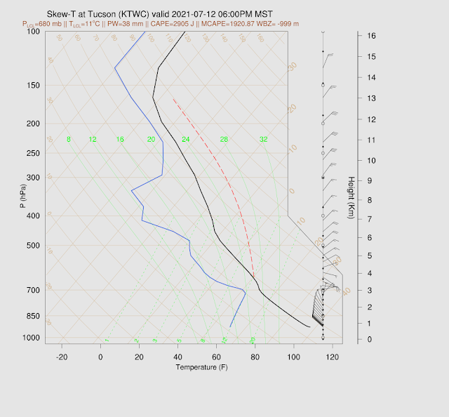
The upper-air data from Tucson indicates a deep moist layer from 700mb to the surface. MLCAPE isn't that high, but the Most Unstable, at 700mb, is over 1400 J/kg. DCAPE is a moderate 1200 J/kg, so strong winds are again likely with storms. Anvil level winds have switched to the W-NW, so anvils will blow away from storm motion, which will again be from the NE to the SW. Based just on the Skew-T, it looks like an active day, as long as the inversion can be overcome at the top of the very moist layer.
Phoenix, not so much, as CAPE is limited. Other parameters all look favorable, though.
Initializations
It's mainly clear over much of the state. However, there is a significant amount of smoke in southern Arizona and into NM. So much that GOES is unable to retrieve PW, as seen below.
Fortunately, we have NASA's GEOS5 aerosol optical depth forecasts going into WRF (Patrick Bunn). It looks like the recent runs have the smoke fairly well initialized and forecast. Thick smoke can really play havoc with model runs if not forecast correctly. In recent years, it's become increasingly important to account for smoke.
The initializations are generally good, except for a glaring exception being in NW Mexico. The MCS has played havoc with PW initialization, which was way too wet for all runs at 12Z. The 6Z GFS looks the best. 9Z RR below.

Day 1
A raging outflow-generated surge is underway in western Arizona with blowing sand and dust and winds gusting to above 40mph. PW has increased to around 45mm. By early afternoon, PW is generally about 40mm, but I'm a bit leary of the forecast due to the uncertainty regarding moisture in NW Mexico. Low-level easterly winds have again pushed into SE Arizona, decreasing chances there. A boundary is again present north-south of a line centered on the Pima/Cochise County border.
850mb dew points are quite high at 14C from Maricopa down to Pima Counties, resulting in a risk of heavy rain with storms.
By early afternoon, CAPE is more than enough to support widespread deep convection. It looks like moisture has finally made it up to the high elevations of the Rim and White Mountains, so big storms are likely there today. With favorable steering, expect these storms to move quickly towards the lower elevations of south-central Arizona.
Storms develop both over the White Mountains and the Chuska Mountains during the afternoon hours. By early evening, a broken line of storms moves across east-central Arizona towards the lower elevations.
I find it fascinating that NE Arizona storms can make it all the way to south-central Arizona. The 600mb vertical velocity animations are especially revealing in how this propagation occurs.
The various runs over the past 24 hours have been consistent with moving this broken squall line into the lower elevations of Pinal and Pima Counties later this evening. Tucson is especially at risk as storms develop to the south of town, resulting in an outflow boundary moving northward. (see the 600mb animations!)
Oh boy, oh boy, oh boy! This is about as good as it gets for Tucson. CAPE is extreme at 2 to nearly 3 thousand J/kg, good low-level shear, and 15-20 knot mid-level flow. Negatives are that anvils will blow out ahead of storms, and there is a moderate inversion on top of the mixed layer. The PBL is quite deep and close to the LFC, so a good outflow boundary or intersecting outflow boundaries will trigger deep convection.
The 12Z WRFRR is similar, except for a more reasonable 1600-1900 J/kg of CAPE. Still, more than enough for a major severe weather event.

My worry is that Tucson model temperature forecasts are quite warmer than observed, perhaps from the smoke and more cooling of the lower atmosphere by the Mexican MCS. If this trend continues, model runs may be too optimistic with storm activity and intensity.
The 9Z WRFRR has the best/worst-case scenario, depending on your point of view. Outflow boundaries converge on Tucson this evening, leading to widespread severe winds in the valley.
On the other end, the 15Z WRFRR (1st image) has considerably less activity and more activity around Phoenix. My guess is what will actually happen is somewhere in the middle, like the 12Z WRFRR (2nd image).
While having an enormous amount of CAPE (1700-3000 J/kg), Phoenix looks unlikely to be much activity as the PBL is strongly capped. It will take multiple OFB intersections to get storms there.
I've been waiting for the 12Z WRFGFS to see if that helps shed any light on the situation. It has a better but not perfect PW initialization, with some moderate errors over southern Arizona/Sonora. It moves severe storms into southern Pinal and northern Pima County this evening.
As with other runs, very strong/severe winds are produced by these storms.
Day 2 will follow later.


No comments:
Post a Comment
Note: Only a member of this blog may post a comment.