Previous Forecast
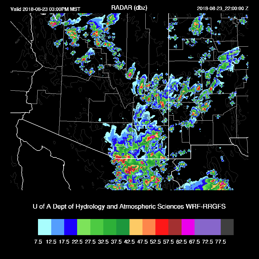
It was an active day over southern Arizona as scattered storms formed during the afternoon hours and produced some very heavy rain. The WRF runs didn’t have enough activity especially west of Tucson. Early morning storms did develop over southern Arizona but not in the Phoenix area as some runs said they would.
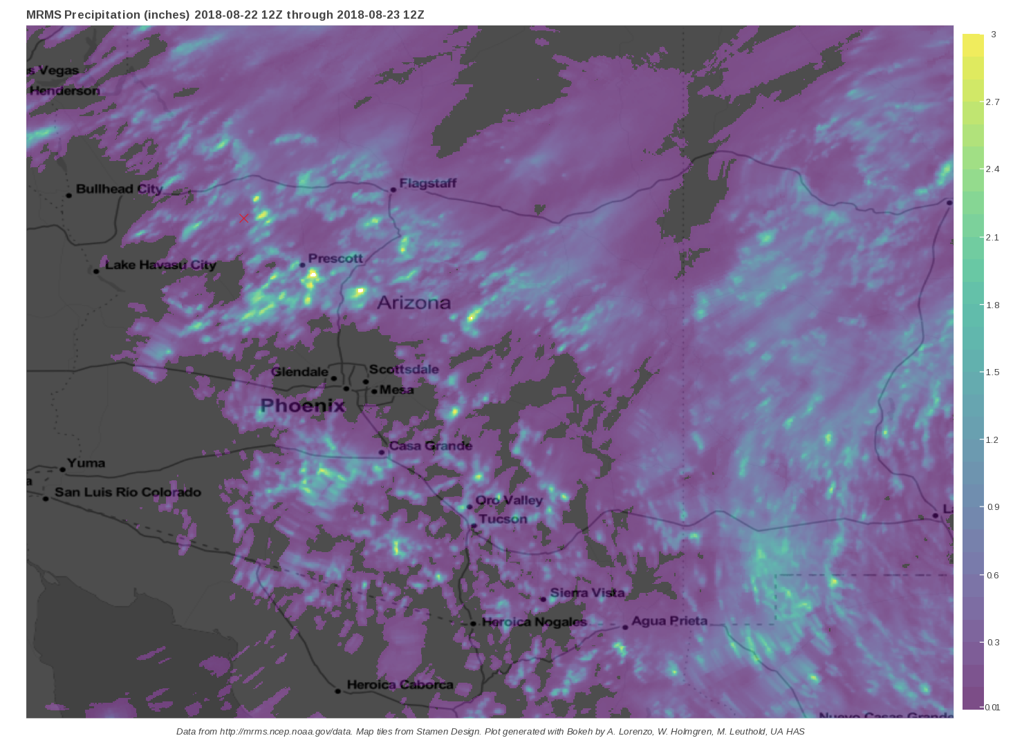
The WRFGFS did better during the day as it had a lot of activity west of Tucson but it didn’t have any of the early morning activity.

Initializations
Oh boy, another complex situation. The 500mb map indicates that Arizona is under generally westerly flow with the center of the 500mb anticyclone over in central Texas. Satellite imagery and mid and upper maps have an IT over Sinaloa and it is moving northwest towards Arizona. Satellite imagery indicates that there is an IT/MCV over far SE Arizona and another MCV over SW NM which looks to all be a part of a f broad weak trough. The NCEP data feed is finally fixed so future runs will be more on time but the NAM is unavailable right now. The RR and 12Z GFS have initialized the upper features fairly well.


Both the RR and GFS have a fair amount of clouds over southern Arizona and while not quite in the right place, they are still pretty good. Also, an area of storms has just popped up to the NW of Tucson and both the WRFRR and WRFGFS were able to forecast these storms. Both the RR and GFS have initialized PW well. The 12Z WRFNAM is sitting in the queue waiting to run but I can see its PW errors. It isn’t too bad over Arizona but too wet in Mexico and over NM and CO. Overall, in spite of the complex nature, the RR and GFS initializations look quite good. Still, forecasting in this extremely moist environment is challenging for the model (and humans!) so I’m not all that confident.

Day 1
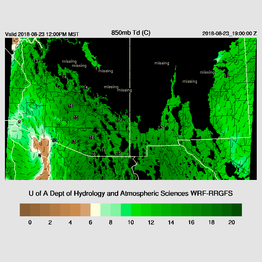
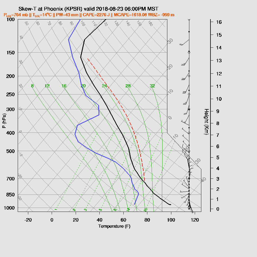
PW is very high over much of southern Arizona and ranges from 43mm at Safford to 48mm around Phoenix. Drying is underway over far western Arizona as it’s dropped to 35mm at Yuma. Weak southerly flow continues to advect moisture into the central and western part of the state, but dry air is moving in aloft over western Arizona. 850mb Td are very high thus many storms are going to have very heavy rain and wet microbursts.
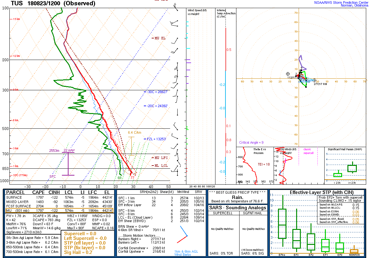
The Tucson sounding has more than 1400 J/kg of CAPE so no wonder there are storms in the vicinity already. Like yesterday, the vertical wind profile has no good (any?) steering flow so storms will randomly wander about and form just about anywhere there is good heating.
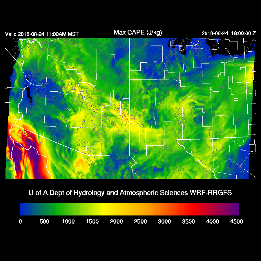
CAPE is forecast to be high over much of the state today.

I better hurry up and get this finished as it become quite active over much of SE Arizona by noon. Outflow from the storms near Tucson may trigger additional storms in the Tucson area.

Activity continues over SE Arizona and the high country throughout the afternoon.
While the various model runs have no actual storms for Phoenix, it’s very unstable as CAPE is from 1300-2000 J/kg this afternoon, depending on the model run, so it is certainly possible that a few storms could form, mainly on the higher terrain, and then drift into the valley. Steering flow is poor thus storms won’t move much and have the potential to produce very heavy rain.
A few storms do get close to the north side this evening.

Day 2
Moisture decreases somewhat but low-level flow continues from the south into the state so there is again a threat of very heavy rain and wet microbursts with storms.

Of great interest is the Mexican IT I mentioned earlier as the WRFRR moves it to just south of the NM Bootheel by mid-day. The WRFGFS keeps it farther to the south but does put SE Arizona in favorable upper difluence and divergence.

The 500mb pattern also has an interesting mid-level IT over SE Arizona and northern Sonora which results in more favorable easterly steering flow at around 10 to 15 knots. From what I can tell, this is the leftover MCV/IT which is in the area today.

CAPE is again high over much of the eastern ½ of the state thus it appears it will be quite an active day tomorrow. Of course, this is all dependent on how much heating occurs.
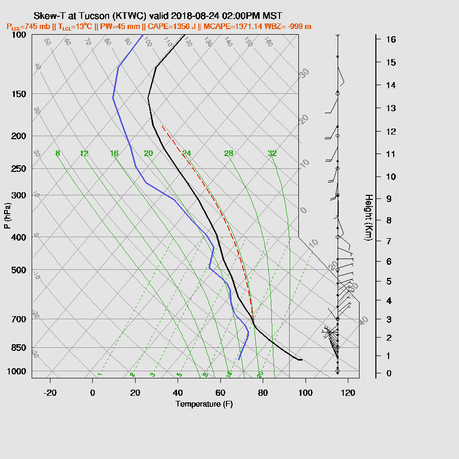
Both the WRFGFS and WRFNAM have an early start to deep convection and areas of SE Arizona and eastern Arizona are active during the afternoon.

The PBL at Tucson is mixed nearly to the LFC (assuming around 700mb) and along with high CAPE and at least a little easterly mid-level flow, it should be very active tomorrow afternoon.
Storms appear to be much more organized compared to recent days due to the more favorable upper and mid-level winds and by late afternoon, both runs have strong storms moving into Eastern Pima and Pinal Counties. 
Phoenix becomes deeply mixed and with some easterly steering flow, it looks likely storms will be in and/or near the Phoenix area during the evening.


No comments:
Post a Comment
Note: Only a member of this blog may post a comment.