Previous Day
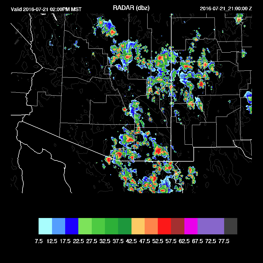
Areas north of Phoenix had an active day with very heavy rain in some spots as the weak IT interacted with moisture. Areas around Tucson and Phoenix were mainly quiet. Both model runs were quite good except for missing the localized very heavy precipitation.


Initializations
I only have time for a quick look at the initializations. Skies are clear and no cyclonic circulations were seen in either the 500mb data or via satellite. Another large upper IT is moving across north central Mexico towards Arizona and may be a factor over the next few days. Upper flow is already strongly difluent across New Mexico. 12Z NAM and RR IPW errors are large over the southern GofC which shouldn't matter much over Arizona at least today. Other than that, the NAM and GFS are fine and model confidence is high.
Day 1, July 21
I'm starting to sound like a broken record as the general synoptic situation remains about the same. One 500mb high center continues to be located in NM with weak southerly flow across the state. As Bob Maddox noted, 500mb temperatures have warmed somewhat running around -6C.

Moisture hasn't decreased much or increased over Arizona thus probably a similar day to yesterday with scattered storms over high elevations that don't move much thus producing localized very heavy rain. Drier air over NM and Chihuahua is trying to work westward on light SE flow.

CAPE continues to be moderate to locally high over the eastern two-thirds of Arizona. There seems to be a bit more present in lower elevations too so there might be more activity around Tucson and Phoenix this afternoon and evening.
Like yesterday, a moderate amount of afternoon CAPE is present and steering winds are weak from the south thus I'd expect a few storms over mainly the south valley this afternoon.

That does seem to be the case as both runs have deep convection firing over the mountains of SE Arizona with storms close to Tucson and up over the Rim and White mountains. The Yavapai county area has less activity this afternoon.

Some storms do move into Pinal county and central Pima by late afternoon, similar to yesterday. The WRFGFS has stronger and more numerous storms over eastern Pima into southern Pinal.
The strength and organization (at least in the WRFGFS) to the afternoon/early evening convection appears to be related to the influence of the upper trough as it nears Arizona.

Also similar to yesterday, the Phoenix vertical profile has somewhat limited CAPE, mainly light and variable steering winds, and an insufficiently mixed PBL thus deep convection in the immediate area will be isolated. Outflows are forecast to be quite strong this evening so perhaps that will be enough to kick off a few weak storms.

Inverted V profiles are quite large this evening and the WRFGFS moves stronger storms into Pinal/Pima county than the WRFNAM thus it produces a large scale strong outflow across that area so there is a risk of a major dust storm in the Pinal/Maricopa county region. It's not a 'slam dunk' as the WRFNAM is much weaker, but this time of year, it doesn't take much wind for a dust storm.
Day 2, July 22
Mid level flow is still poor. However, an IT has materialized over the northern GofC (big MCV? reflection of the upper trough?) in the model runs with the WRFGFS being quite strong.

The upper IT is located in northern Sonora with divergence/difluence over much of the state.

What appears to be preventing a big day is the slow decrease in moisture, especially over eastern Arizona as weak easterlies advect in the dry air there. There is still sufficient moisture for scattered storms over much of the higher terrain of the state.

Both model runs are similar looking with scattered late afternoon storms over the higher terrain. Less coverage than today.

Having said just said 'less coverage', the WRFGFS develops very strong/severe storms during the evening across parts of Pima county while the WRFNAM has no activity. The WRFGFS has typically been somewhat too active so don't count on it.
Areas north of Phoenix had an active day with very heavy rain in some spots as the weak IT interacted with moisture. Areas around Tucson and Phoenix were mainly quiet. Both model runs were quite good except for missing the localized very heavy precipitation.


Initializations
I only have time for a quick look at the initializations. Skies are clear and no cyclonic circulations were seen in either the 500mb data or via satellite. Another large upper IT is moving across north central Mexico towards Arizona and may be a factor over the next few days. Upper flow is already strongly difluent across New Mexico. 12Z NAM and RR IPW errors are large over the southern GofC which shouldn't matter much over Arizona at least today. Other than that, the NAM and GFS are fine and model confidence is high.
Day 1, July 21
I'm starting to sound like a broken record as the general synoptic situation remains about the same. One 500mb high center continues to be located in NM with weak southerly flow across the state. As Bob Maddox noted, 500mb temperatures have warmed somewhat running around -6C.

Moisture hasn't decreased much or increased over Arizona thus probably a similar day to yesterday with scattered storms over high elevations that don't move much thus producing localized very heavy rain. Drier air over NM and Chihuahua is trying to work westward on light SE flow.

CAPE continues to be moderate to locally high over the eastern two-thirds of Arizona. There seems to be a bit more present in lower elevations too so there might be more activity around Tucson and Phoenix this afternoon and evening.
 |
| WRFGFS |
Like yesterday, a moderate amount of afternoon CAPE is present and steering winds are weak from the south thus I'd expect a few storms over mainly the south valley this afternoon.

That does seem to be the case as both runs have deep convection firing over the mountains of SE Arizona with storms close to Tucson and up over the Rim and White mountains. The Yavapai county area has less activity this afternoon.
Some storms do move into Pinal county and central Pima by late afternoon, similar to yesterday. The WRFGFS has stronger and more numerous storms over eastern Pima into southern Pinal.
 |
| WRFGFS |

Also similar to yesterday, the Phoenix vertical profile has somewhat limited CAPE, mainly light and variable steering winds, and an insufficiently mixed PBL thus deep convection in the immediate area will be isolated. Outflows are forecast to be quite strong this evening so perhaps that will be enough to kick off a few weak storms.

Inverted V profiles are quite large this evening and the WRFGFS moves stronger storms into Pinal/Pima county than the WRFNAM thus it produces a large scale strong outflow across that area so there is a risk of a major dust storm in the Pinal/Maricopa county region. It's not a 'slam dunk' as the WRFNAM is much weaker, but this time of year, it doesn't take much wind for a dust storm.
 |
| WRFGFS |
Day 2, July 22
Mid level flow is still poor. However, an IT has materialized over the northern GofC (big MCV? reflection of the upper trough?) in the model runs with the WRFGFS being quite strong.

The upper IT is located in northern Sonora with divergence/difluence over much of the state.

What appears to be preventing a big day is the slow decrease in moisture, especially over eastern Arizona as weak easterlies advect in the dry air there. There is still sufficient moisture for scattered storms over much of the higher terrain of the state.

Both model runs are similar looking with scattered late afternoon storms over the higher terrain. Less coverage than today.

Having said just said 'less coverage', the WRFGFS develops very strong/severe storms during the evening across parts of Pima county while the WRFNAM has no activity. The WRFGFS has typically been somewhat too active so don't count on it.
 |
| WRFGFS |
No comments:
Post a Comment
Note: Only a member of this blog may post a comment.