Previous Day
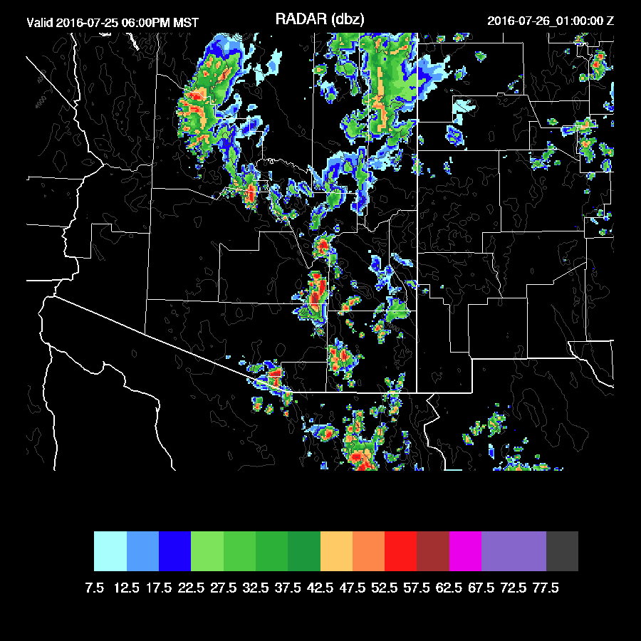
Once again, most of the model runs predicted too many storms around the Tucson area, but some did well in SE Arizona where there were big storms overnight. I've been scratching my head regarding the large IPW errors that have been occurring around Hermosillo as I would of though with the MMGM (Guaymas) sounding returning, that area would have the least amount of errors. It turns out that the MMGM sondes have and have been reporting nearly saturated conditions all the way up. Below is an example of a previous couple of days.

The Hermosillo Suominet site, which is fairly near, has reported from .5 to .75" of an inch less. Does this have something to do with the model errors here in southern Arizona? Perhaps as my correction routine has limits with large errors like this.
The EMX RADAR has been down a few days thus I'm using the 24 hour lightning plot as validation. Very impressive amounts of lightning over Cochise county and down south.

The 6Z and 12Z WRFNAM runs were quite good. The 12Z had activity a bit too far to the west. The 15Z WRFRR dev version was also pretty good.
Initializations
Widespread clouds are present over southeastern Arizona and not initialized well by any of the 12Z runs. Fortunately, clouds are burning off thus this may have minimal impact and looking at the model temperatures, this does seem to be the case.
Again, the MMGM sounding looks suspect but the sounding IPW is similar to nearby observations so who knows?

All the 12Z initializations are struggling with a wet bias mainly over NW Mexico and into NM. The NAM has some 5-8mm errors in Mexico. I took a quick look at 6Z and IPW errors were smaller thus I may look at those runs also.
There are no obvious inverted troughs around the area except for an MCV just south of Nogales, moving west. The RR was the only model to pick this feature up. There are some errors today and model confidence is only medium and there are no clear favorites.
Day 1, July 25
IPW has generally increased the past 12 hours and by early afternoon, quite high amounts of moisture are present as a weak surge continues.

Moisture in the BPL is quite high as 850mb Td are 12 C or higher.

The CAPE forecast is similar to yesterday with the highest amounts from SE Arizona up towards Flagstaff. Some areas are very high and will result in strong storms with very heavy rain and intense lightning.

The late afternoon Tucson sounding is again quite impressive with 1300 J/Kg of CAPE, low-level shear and a bit of easterly steering flow. However, will IPW again drop in the afternoon like it has been doing recently? Keep an eye on the real-time Suominet data.

Deep convection is underway by early afternoon over the usual locations excluding SE Arizona. By late afternoon/early evening, storms are trying to make their way into the lower elevations of Maricopa/Pinal/Pima counties.

Both the WRFNAM and WRFGFS have activity in and around Tucson with the WRFGFS being more active and also developing another MCS south of the border.

Once again, the Phoenix area looks to be mainly inactive as CAPE is marginal, steering is poor, and the PBL is not mixed deeply.

This just in from the WRFRR-dev.....It is very active in SE Arizona and west of Flagstaff by late afternoon/early evening. I'm still somewhat skeptical and will only believe it as long as the Tucson area IPW remains around 40mm this afternoon. Also, as I mentioned that the 6Z runs looked OK, they too forecast big storms in and around Tucson during the evening so perhaps Tucson will finally see a big outbreak.

Strong outflows are ejected into Pinal and Maricopa counties early this evening but CAPE is minimal and no deep convection develops.

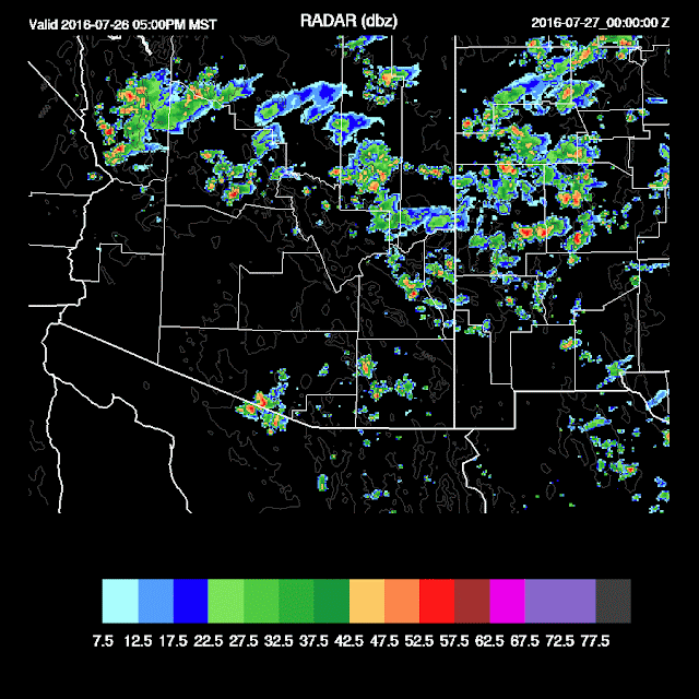
Day 2, July 26
Tomorrow looks worse as the high continues to meander around the Four Corners area with weak easterly flow only across the southern part of the state. Quite warm 500mb air is also present with temperatures around -5C.

Moisture decreases somewhat and combined that with slight mid level warming, expect less activity.

Scattered activity mainly over the higher elevations during the afternoon and early evening. Sad!
Once again, most of the model runs predicted too many storms around the Tucson area, but some did well in SE Arizona where there were big storms overnight. I've been scratching my head regarding the large IPW errors that have been occurring around Hermosillo as I would of though with the MMGM (Guaymas) sounding returning, that area would have the least amount of errors. It turns out that the MMGM sondes have and have been reporting nearly saturated conditions all the way up. Below is an example of a previous couple of days.

The Hermosillo Suominet site, which is fairly near, has reported from .5 to .75" of an inch less. Does this have something to do with the model errors here in southern Arizona? Perhaps as my correction routine has limits with large errors like this.
The EMX RADAR has been down a few days thus I'm using the 24 hour lightning plot as validation. Very impressive amounts of lightning over Cochise county and down south.

The 6Z and 12Z WRFNAM runs were quite good. The 12Z had activity a bit too far to the west. The 15Z WRFRR dev version was also pretty good.
 |
| 15Z WRFRR dev |
 |
| WRFNAM |
Initializations
Widespread clouds are present over southeastern Arizona and not initialized well by any of the 12Z runs. Fortunately, clouds are burning off thus this may have minimal impact and looking at the model temperatures, this does seem to be the case.
Again, the MMGM sounding looks suspect but the sounding IPW is similar to nearby observations so who knows?

All the 12Z initializations are struggling with a wet bias mainly over NW Mexico and into NM. The NAM has some 5-8mm errors in Mexico. I took a quick look at 6Z and IPW errors were smaller thus I may look at those runs also.
There are no obvious inverted troughs around the area except for an MCV just south of Nogales, moving west. The RR was the only model to pick this feature up. There are some errors today and model confidence is only medium and there are no clear favorites.
Day 1, July 25
IPW has generally increased the past 12 hours and by early afternoon, quite high amounts of moisture are present as a weak surge continues.

Moisture in the BPL is quite high as 850mb Td are 12 C or higher.

The CAPE forecast is similar to yesterday with the highest amounts from SE Arizona up towards Flagstaff. Some areas are very high and will result in strong storms with very heavy rain and intense lightning.

The late afternoon Tucson sounding is again quite impressive with 1300 J/Kg of CAPE, low-level shear and a bit of easterly steering flow. However, will IPW again drop in the afternoon like it has been doing recently? Keep an eye on the real-time Suominet data.

Deep convection is underway by early afternoon over the usual locations excluding SE Arizona. By late afternoon/early evening, storms are trying to make their way into the lower elevations of Maricopa/Pinal/Pima counties.
Both the WRFNAM and WRFGFS have activity in and around Tucson with the WRFGFS being more active and also developing another MCS south of the border.

Once again, the Phoenix area looks to be mainly inactive as CAPE is marginal, steering is poor, and the PBL is not mixed deeply.

This just in from the WRFRR-dev.....It is very active in SE Arizona and west of Flagstaff by late afternoon/early evening. I'm still somewhat skeptical and will only believe it as long as the Tucson area IPW remains around 40mm this afternoon. Also, as I mentioned that the 6Z runs looked OK, they too forecast big storms in and around Tucson during the evening so perhaps Tucson will finally see a big outbreak.

Strong outflows are ejected into Pinal and Maricopa counties early this evening but CAPE is minimal and no deep convection develops.

Day 2, July 26
Tomorrow looks worse as the high continues to meander around the Four Corners area with weak easterly flow only across the southern part of the state. Quite warm 500mb air is also present with temperatures around -5C.

Moisture decreases somewhat and combined that with slight mid level warming, expect less activity.

Scattered activity mainly over the higher elevations during the afternoon and early evening. Sad!

No comments:
Post a Comment
Note: Only a member of this blog may post a comment.