Previous Day
The WRFGFS and WRFNAM did a pretty good job with areal coverage of precipitation in Arizona. They were unable to capture the intensity of the isolated very heavy rain that occurred. Also, they had the right idea of a few storms around Phoenix, but the timing was off by 3 hours as they had activity there around 9-11pm.

Initializations
Morning clouds were mainly isolated and are slowly dissipating. A few showers are along the eastern border and another area of clouds are associated with a MCV in far northern Sonora. WV imagery indicates the upper IT is just south of El Paso and slowly moving WNW and another weak feature moving north near Yuma. 12Z initializations have missed the Sonoran MCV but do have the IT south of El Paso. The Yuma area IT seems to be responsible for the showers west of Phoenix. The model initializations don't have much in that area and in general, not enough clouds.
IPW was initialized well by all 12Z models. Overall, initializations were good as the cloud problems were minor.
Day 1, July 19
The weak gulf surge has petered out, but plenty of moisture remains over the state to support scattered afternoon and evening activity. Looking at IPW forecasts at 15Z, the WRFGFS is the most accurate as the WRFNAM is a couple of mm too wet around Tucson and Phoenix.

CAPE is forecast to be moderate to fairly high over SE AZ and up to Flagstaff. This is the highest it has been recently thus it looks like an active day for those areas.

Deep convection initiates earlier than usual and by early afternoon, high terrain locations already have activity, with some strong storms present.

The early afternoon Tucson Skew-t plot forecast indicates a moderate amount of CAPE and OK mid level steering with a bit of low level shear. The PBL is already mixed deeply thus it looks like activity in and around Tucson by mid afternoon.

The upper IT continues to place SE Arizona under difluent flow aloft with areas of divergence present thus helping to support deep convection.

Both model runs have scattered convection in and around Tucson by mid afternoon. As the inverted V profile isn't that deep, thunderstorm outflow winds are not expected to be high. Isolated strong/severe winds are still possible with stronger storms.

The late afternoon forecast profile at Phoenix has only limited CAPE as well as an inversion at the top of the PBL which is going to take some work to break. Winds are somewhat favorable as there is a bit of low level shear and 15knot SE steering. It appears storms will be close to Phoenix with maybe a few in the valley.

Of interest for the Phoenix area is the late afternoon activity nearby that do eject outflows towards the valley thus providing the lift needed for deep convection in the lower elevations. Too bad that CAPE isn't higher.

The WRFNAM does develop a few storms around the Phoenix area during the early evening while the WRFGFS does not. SE Arizona stays active during the evening probably due to the influence of the upper IT.
The WRFGFS is especially active over SE Arizona with perhaps even storms as far west as Tucson and a few scattered up towards Phoenix.
Day 2, July 20
Moderately wet air continues over most of the state thus afternoon and evening.
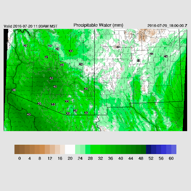
CAPE is not forecast to be as high so somewhat less coverage and intensity.

Mid level steering weakens and the upper IT is sheared apart thus activity will mostly remain over higher terrain.

Scattered storms over higher terrain by mid to late afternoon.

Little or no activity in Phoenix.
The WRFGFS and WRFNAM did a pretty good job with areal coverage of precipitation in Arizona. They were unable to capture the intensity of the isolated very heavy rain that occurred. Also, they had the right idea of a few storms around Phoenix, but the timing was off by 3 hours as they had activity there around 9-11pm.

 |
| WRFGFS |
Morning clouds were mainly isolated and are slowly dissipating. A few showers are along the eastern border and another area of clouds are associated with a MCV in far northern Sonora. WV imagery indicates the upper IT is just south of El Paso and slowly moving WNW and another weak feature moving north near Yuma. 12Z initializations have missed the Sonoran MCV but do have the IT south of El Paso. The Yuma area IT seems to be responsible for the showers west of Phoenix. The model initializations don't have much in that area and in general, not enough clouds.
IPW was initialized well by all 12Z models. Overall, initializations were good as the cloud problems were minor.
Day 1, July 19
The weak gulf surge has petered out, but plenty of moisture remains over the state to support scattered afternoon and evening activity. Looking at IPW forecasts at 15Z, the WRFGFS is the most accurate as the WRFNAM is a couple of mm too wet around Tucson and Phoenix.

CAPE is forecast to be moderate to fairly high over SE AZ and up to Flagstaff. This is the highest it has been recently thus it looks like an active day for those areas.

Deep convection initiates earlier than usual and by early afternoon, high terrain locations already have activity, with some strong storms present.

The early afternoon Tucson Skew-t plot forecast indicates a moderate amount of CAPE and OK mid level steering with a bit of low level shear. The PBL is already mixed deeply thus it looks like activity in and around Tucson by mid afternoon.

The upper IT continues to place SE Arizona under difluent flow aloft with areas of divergence present thus helping to support deep convection.

Both model runs have scattered convection in and around Tucson by mid afternoon. As the inverted V profile isn't that deep, thunderstorm outflow winds are not expected to be high. Isolated strong/severe winds are still possible with stronger storms.

The late afternoon forecast profile at Phoenix has only limited CAPE as well as an inversion at the top of the PBL which is going to take some work to break. Winds are somewhat favorable as there is a bit of low level shear and 15knot SE steering. It appears storms will be close to Phoenix with maybe a few in the valley.

Of interest for the Phoenix area is the late afternoon activity nearby that do eject outflows towards the valley thus providing the lift needed for deep convection in the lower elevations. Too bad that CAPE isn't higher.

The WRFNAM does develop a few storms around the Phoenix area during the early evening while the WRFGFS does not. SE Arizona stays active during the evening probably due to the influence of the upper IT.
 |
| WRFNAM |
 |
| WRFGFS |
Day 2, July 20
Moderately wet air continues over most of the state thus afternoon and evening.

CAPE is not forecast to be as high so somewhat less coverage and intensity.

Mid level steering weakens and the upper IT is sheared apart thus activity will mostly remain over higher terrain.

Scattered storms over higher terrain by mid to late afternoon.

Little or no activity in Phoenix.
No comments:
Post a Comment
Note: Only a member of this blog may post a comment.